 Real-Time Kinematic (RTK) is a buzz term in the UA industry, one many pilots may not understand, even though they may be “mapping” with an uncrewed aircraft (drone). When it comes to RTK and drone mapping, how necessary is the technology to a drone services provider? Will it earn a services provider more money?
The following is a guest post by drone industry veteran Douglas Spotted Eagle, Production and Education Director at Sundance Media Group. DRONELIFE neither accepts nor makes payment for guest posts.
All images courtesy Sundance Media Group, used with permission.
When a manufacturer provides RTK capability, some feel they’ve achieved nirvana, and are ready to start a drone surveying business, but…
Not so fast there, pardner. There is a significant difference between owning an RTK aircraft and being a surveyor. A surveying degree is at minimum, four years of school and depending on the area of interest, up to six years of school plus time in the field, plus passing the land surveying exams will allow an individual to gain a license to survey.
As UA grows in popularity, tight accuracy and precision are becoming more attainable. It’s also important to realize that there are different degrees of accuracy that are considered “survey grade” and the term “survey” has very different meanings in various endeavors.
In AEC (Architecture, Engineering, Construction), an acceptable accuracy falls into “tenths” while Surveyors work in hundredths or thousandths.
Why does this matter? When discussing UA, it’s critical to know the level of precision the aircraft and accompanying system will provide. At a recent conference for example, a presenter claimed that with their dual RTK aircraft, they are capable of repeatable precision (accuracy) of less than 1/1000. This is highly dubious.
How does this all work then? Why is it important?
First, let’s define the differences between “Mapping” and “Surveying.”
Mapping with a UA system, creates a flattened, “localized” image of a ground area, that contains measurable data with some degree of measurability. The accuracy of measurements is affected by several factors, such as altitude of flight (ground sampling distance), size of image sensor, curvature of lens, latency of shutter to antenna, and other factors.
Surveying creates an ortho-corrected, localized image or drawing of a ground area which contains measurable data with a highly accurate and precise measurability. Construction surveys allow for a greater slide in precision vs land survey and this too is important to understand, while going beyond the scope of this article.
An RTK aircraft receives “corrections” from a known grid system, via a couple of different technologies. This allows the aircraft to know with much greater precision, where it sits in XYZ space as referenced to the ground locations. These corrections, received during the flight, are written to the image metadata contained in each photo the aircraft captures. When this data is imported into a processing software such as Pix4DMapper, Leica Infinity, 3DR, etc, the data becomes “localized” and if all parameters are properly set, the localized data, in the form of an ortho, become measurable with a great degree of accuracy.
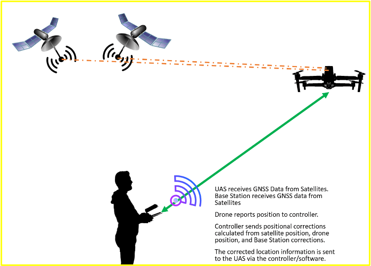
HOW A NON-RTK AIRCRAFT CAPTURES AERIAL POSITION:
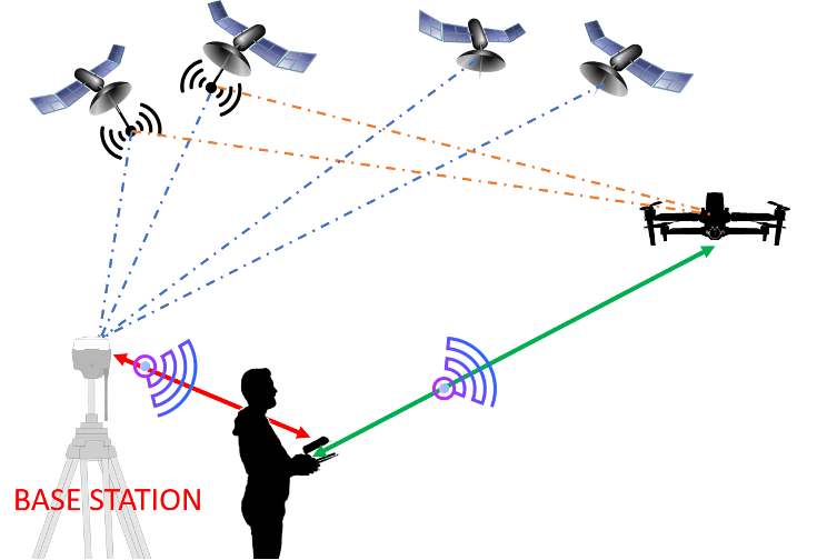
HOW AN RTK-CAPABLE AIRCRAFT CAPTURES POSITION with a BASE STATION:
HOW AN RTK AIRCRAFT DETERMINES POSITION with NTRIP:
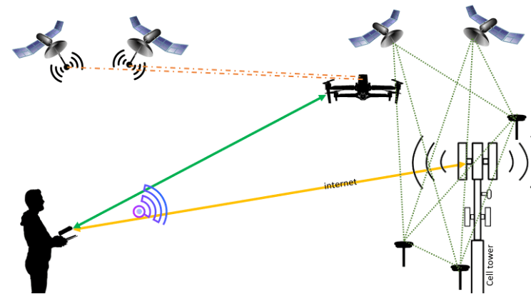
Networked Transport of RTCM via Internet Protocol (NTRIP) is a serviced provided across much of the world. In order to use this type of correction, a cellular modem, a receiver capable of RTK correction and a cellular data plan are required. Some regions provide the NTRIP data connection at no cost (usually through a State or municipal service) or for a nominal, typically annual, fee. NTRIP data is transmitted via RTCM, which carries the correctional information. The NTRIP server is in constant contact with GNSS nodes surrounding many areas of the United States. This server constantly broadcasts GPS data via wifi, and is used to provide wireless transmission of location data to many different industries. For example, NTRIP is heavily used by agriculture, driverless cars, area inventory management, surveyors, engineers, departments of transportation.
The NTRIP nodes/stations are fixed at known positions, and are constantly receiving satellite location data. The collective nodes feed a server, which aggregates the location data between the nodes and satellites, and sends out a correctional data stream, informing a “rover” device of it’s actual location in XYZ space. It is very, very accurate, providing capability of 1cm (.39”) in horizontal and 1.5cm in vertical precision. This is good enough for most sorts of aerial precision work.
HOW DO WE MEASURE ACCURACY?
First and foremost, we need a known point, if we’re using only UA and a Base station or NTRIP corrections system.
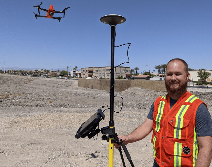
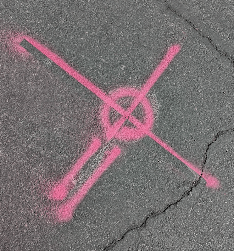
These might be captured using a variety of GPS systems, such as the DT Research 301 (pictured here), with a rod and bi-pole over a Hoodman Ground Control Point system, or perhaps something more elaborate such as a Leica GS18 receiver or a more affordable, yet less flexible Emlid RS2 Base/Rover system. The Ground Control Points (controls), may be mobile, or may be painted on the ground as seen below. This is more common; a special nail that has grids or a detented point for precision, is driven into the ground and spray paint marks the area. Paint may be applied to rapidly find the nail while walking or flying. This is special surveyor paint, which can be purchased at most any survey supply (usually in cases of 12 cans).
The known point (also known as a “check”), is to be compared to the data provided by the UA as relative to that known point. The difference marks our ellipsis of error. Tools such as Leica Infinity, Pix4D, and similar are able to demonstrate the differences in location. Generally, the aircraft data should be within 1-2 cm of the known point captured from a static position.
Sometimes, these known checkpoints may be accessed via a county or state system, where known monument points set by a professional land surveyor have been recorded.
ONCE THESE PARAMETERS ARE MET….
Precision can occur.
Let’s look at various examples of accuracy and precision.
First, we’ve got an image captured from a UA flying at 75’ in altitude, no correction network, projecting where it will be when locked to ground (localized) and how accurate to position it is. This accuracy is only slightly greater than the accuracy of a cell phone GPS system (not very accurate).
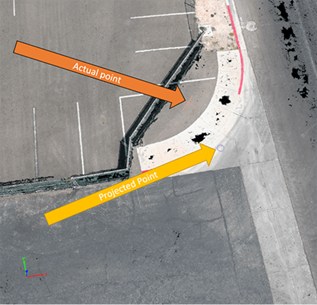
In this image, the projected point is nearly 10’ off from the actual point (captured with a Leica GS18i). This level of accuracy is not very useful in any kind of construction nor survey environment. This is captured via autonomous flight, compared to a static position with the Leica GS18i. The UA has no RTK capability. This is the level of accuracy a typical UA will provide, depending on sensor size, speed, and altitude.
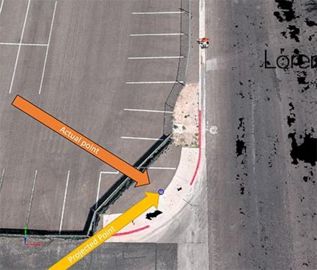
In this image, we see the projected point is much closer to the actual point, as an RTK antenna system with no corrections (NTRIP or Base Station) applied in flight. The projected and actual difference is 18.5”. Close, but not close enough for most kinds of work.
Last, we can see what occurs when an NTRIP or Base Station are applied in flight.

In this scenario, the actual and projected points are offset by approximately 1cm. This level of accuracy is required for most commercial applications. This image was captured with an Autel EVO II RTK aircraft corrected via NTRIP network, processed in Pix4DMapper using checkpoints.
CAN I MAKE MORE MONEY WITH AN RTK DRONE, BASE STATION, and NTRIP?
Generally speaking, yes. Pilots need to understand and have experience with much more than merely programming an automated mission and capturing nadir images in order to be a benefit to a survey company, regardless of whether it’s survey for construction, ALTAs, or land. The value (what you charge) is dependent on the amount of time, improvement on data demonstration, and other benefits the UA brings.
HOW DO I KNOW MY COORDINATES AND SCALE ARE ACCURATE?
This is where the math and understanding of coordinates are required. Different companies will have various means of determining localized “truth.” Some are very regimented, while others are informal and may involve only a few checkpoints. The American Society for Photogrammetry and Remote Sensing (ASPRS) offers guidelines on verification of accuracy, most of which are beyond the means of a typical UA pilot and their equipment.
Key components of ASPRS Positional Accuracy Standards
- Accuracy is measured by the RMSE (Root Mean Squared Error) of the difference between modeled points and independently measured points.
- Accuracy can only be accurately measured using Checkpoints that were not included in the production of the model.
- Ground measurements must be made with an independent source of higher accuracy than the aerial mapping system.
- Horizontal and Vertical accuracy should be measured independently, and can have different properties depending on vegetation.
SO, IF I HAVE AN RTK AIRCRAFT AND ITS VERY PRECISE, WHY CAN’T I BE A SURVEYOR IN MOST STATES?
Most states require licensure from an accredited testing system/program. Licensure candidates typically must pass the Fundamentals of Surveying (FS) exam, the Principles and Practice of Surveying (PS) exam, and a state-specific exam. Check with your state licensing board for state-specific exam information and requirements. A few states require only a high school diploma in addition to testing.
IF I CAN’T BE A SURVEYOR, WHY USE AN RTK SYSTEM?
Whether you’re a surveyor, contractor, or UA pilot looking for opportunities to work with UA in precision-focused environments. RTK workflows provide precise data when properly managed and applied. This is a benefit to anyone using any kind of mapping whether it’s DTM, DEM, Contours, or a simple ortho. Knowing the data has been localized and to scale is important to anyone providing measurements, whether for accident scene reconstruction in public safety, or for determining boundaries and corners for land development.
Read more about RTK mapping:
- viDoc Rover and Pix4Dcatch: viDoc RTK Now Available in US and Canada for RTK Accuracy on an iPhone or iPad
- Generate 3D Models on Mobile Devices with 5cm Accuracy: New from Pix4D, the viDoc RTK Rover
- DJIs New Commercial Drone is Their Most Advanced Platform Yet: the Matrice 300 RTK
- Drone Mapping: Validating the Accuracy of DJIs Phantom 4 RTK
- Yuneec Unveils RTK Satellite Navigation For H520 Drone
 Douglas Spotted Eagle is the Founder and Director of Educational Programming at Sundance Media Group. SMG serves as a consultant within the sUAS industry, offering training and speaking engagements on sUAS topics: UAV cinematography, commercial and infrastructural sUAS applications, sUAS risk management, night UAV flight, aerial security systems, and 107 training.

Miriam McNabb is the Editor-in-Chief of DRONELIFE and CEO of JobForDrones, a professional drone services marketplace, and a fascinated observer of the emerging drone industry and the regulatory environment for drones. Miriam has penned over 3,000 articles focused on the commercial drone space and is an international speaker and recognized figure in the industry. Miriam has a degree from the University of Chicago and over 20 years of experience in high tech sales and marketing for new technologies.
For drone industry consulting or writing, Email Miriam.
TWITTER:@spaldingbarker
Subscribe to DroneLife here.


[…] More… […]