• Skip to main content
  • Skip to secondary menu
  • Skip to primary sidebar
  • Skip to secondary sidebar
  • Skip to footer
  • DroneRacingLife
  • DroneFlyers
  • Newsletter
DroneLife

DRONELIFE

Stay up to date on all the latest Drone News

  • News
  • Products
  • Industries
    • Agriculture
    • Construction
    • Delivery
    • Dual Use
    • Inspection
    • Public Safety
    • Surveying
  • Enthusiasts
  • Regulations
  • Business
  • Video
  • Podcasts

Yuneec Unveils RTK Satellite Navigation For H520 Drone

February 1, 2019 by Malek Murison 8 Comments

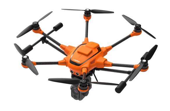
Drone manufacturer Yuneec has announced that its commercial hexacopter, the H520, will now be optionally available with an RTK (Real Time Kinematic) system. The addition of the RTK system from Swiss company Fixposition, means that even under difficult GPS conditions – in dense urban areas or canyons, for example – pilots and aerial data gatherers can benefit from centimeter-precise positioning.

Yuneec is targeting commercial applications in which accurate recurring images, faster 3D mapping and automated inspection flights need to be as precise as possible.

yuneec H520 RTK

Read more: One InterDrone Announcement Stands Out from the Crowd: 3DR, Yuneec and Dronecode

What is RTK?

Real Time Kinematic is a technique that improves the accuracy of GPS signals. Usually this is done with the help of a fixed base station wirelessly broadcasting corrections to a moving receiver. In the case of the H520, there will be an RTK module on board of the H520 that receives information from a base station.

Yuneec say that the new receiver and base station combination allows the H520 to reach centimeter-level precision in under 30 seconds.

In case pilots don’t want to use a base station, the new system from Yuneec can also be operated with a network RTK reference station (Network RTK through third party provider. This requires an internet connection and additional fees will most probably apply.

So what does this mean in practical terms for drone operations? Well, many commercial missions require precision, whether pilots are mapping small areas or setting up autonomous inspections. By using RTK technology, the H520 can now fly much closer to objects for inspection.

You can imagine how important this degree of accuracy is in cases where multiple images need to be recorded from the same exact location on different days. No doubt pilots documenting progress on construction sites or mines will appreciate the improved precision.

The new navigation system also it possible to reduce image overlaps. In practice that means fewer photos and shorter model calculation times, speeding up workflows, not just data gathering. 

Yuneec’s H520 RTK

 The H520 RTK works with two components: the RTK module on board the H520 and a base station on the ground. For precise navigation, the module supports constellations of up to three different satellite systems from GPS, GLONASS, Galileo and BeiDou.

The H520 RTK will be available in the second quarter of 2019 in different configurations:  as a complete system including the H520 airframe and RTK module, for $3199, and as an upgrade for existing H520 customers for $1699. The H520 RTK GPS ground station will be sold separately for $2399.

The complete specs and technical details of the Yuneec H520 with RTK system can be found here.

Malek Murison
Malek Murison

Malek Murison is a freelance writer and editor with a passion for tech trends and innovation. He handles product reviews, major releases and keeps an eye on the enthusiast market for DroneLife.
Email Malek
Twitter:@malekmurison

Subscribe to DroneLife here.

Filed Under: Business and Finance, Drone News Feeds, Featured - Surveying, Mining and Aggregates, News, Products, Technology Tagged With: H520 drone, Real Time Kinematic, rtk, Yuneec

Reader Interactions

Trackbacks

  1. विशेषज्ञों ने अपराध स्थल की जांच के लिए 4 अलग-अलग ड्रोन मैपिंग समाधानों का परीक्षण किया। यहाँ क्य says:
    October 4, 2021 at 5:54 am

    […] विमान शामिल हैं। डीजेआई मविक, प्रेत 4, यूनीक H520, स्काईडियो, और ऑटेल ईवीओ श्रृंखला […]

    Reply
  2. Experts Tested 4 Different Drone Mapping Solutions for Crime Scene Investigation. Here’s What Happened. - Summer Of Drones News says:
    September 29, 2021 at 11:43 am

    […] and tradeshows since 2017, with quite a lot of plane together with DJI Mavic, Phantom 4, Yuneec H520, Skydio, and Autel EVO series (variations 1 and a pair of). All efficiently output knowledge, […]

    Reply
  3. Alpha Unmanned Systems Partners With Inmarsat For BVLOS Deli… – UAV – DRONEENEWS.COM says:
    February 26, 2019 at 1:07 pm

    […] Read more: Yuneec Unveils RTK Satellite Navigation For H520 Drone […]

    Reply
  4. Alpha Unmanned Systems Partners With Inmarsat For BVLOS Delivery Trials - Drones Crunch says:
    February 26, 2019 at 11:06 am

    […] Read more: Yuneec Unveils RTK Satellite Navigation For H520 Drone […]

    Reply
  5. Yuneec Unveils RTK Satellite Navigation For H520 Drone – MyDroneWorld says:
    February 3, 2019 at 4:36 am

    […] Source link […]

    Reply
  6. Yuneec Unveils RTK Satellite Navigation For H520 Drone - Drones Crunch says:
    February 2, 2019 at 1:33 am

    […] DRONELIFE […]

    Reply
  7. Yuneec Unveils RTK Satellite Navigation For H520 Drone – Top Drones & reviews says:
    February 1, 2019 at 10:20 pm

    […] post Yuneec Unveils RTK Satellite Navigation For H520 Drone appeared first on […]

    Reply
  8. Yuneec Unveils RTK Satellite Navigation For H520 Drone | Drone Magazine says:
    February 1, 2019 at 8:38 pm

    […] Source […]

    Reply

Leave a Reply Cancel reply

Your email address will not be published. Required fields are marked *

Primary Sidebar

LATEST

Is U.S. Manufacturing the Answer? SKYROVER Signals a New Strategy as FCC Pressure Mounts

A Hong Kong-based drone company outlines a five-year U.S. roadmap, raising questions about compliance, supply chains, and market access A…

Continue Reading Is U.S. Manufacturing the Answer? SKYROVER Signals a New Strategy as FCC Pressure Mounts

Blue Marble Geographics and Avenza Systems Combine to Create Unified Geospatial Platform

Merger connects office-based analysis with field operations for end-to-end spatial workflows Blue Marble Geographics and Avenza Systems, Inc. have announced…

Continue Reading Blue Marble Geographics and Avenza Systems Combine to Create Unified Geospatial Platform

Amazon Prime Air Adjusts Course After Richardson Setbacks

After rocky start in Texas city, Amazon Air service flying high By DRONELIFE Features Editor Jim Magill After only a…

Continue Reading Amazon Prime Air Adjusts Course After Richardson Setbacks

Airspace Security at 2026 JUNO Awards

RF-Cyber counter-drone system enables non-disruptive protection for large public event D-Fend Solutions announced that its EnforceAir counter-drone system was deployed…

Continue Reading Airspace Security at 2026 JUNO Awards

Will States Be Ready with Counter Drone Tech for the FIFA World Cup?

Funding snafu, other issues delay counter-UAS ramp-up in Maryland, elsewhere By DRONELIFE Features Editor Jim Magill (Editor’s note: This is…

Continue Reading Will States Be Ready with Counter Drone Tech for the FIFA World Cup?

Strait of Hormuz Tensions Highlight a Growing Role for Small Drone Surveillance

Maritime risk, insurance pressure, and degraded navigation signals point to new use cases for commercial UAV systems Ongoing tension in…

Continue Reading Strait of Hormuz Tensions Highlight a Growing Role for Small Drone Surveillance

From Missions to Management: The Shift Defining Public Safety Drone Programs [DRONELIFE Exclusive Interview]

As public safety drone use scales, data, compliance, and coordination define success Public safety drone programs have reached an inflection…

Continue Reading From Missions to Management: The Shift Defining Public Safety Drone Programs [DRONELIFE Exclusive Interview]

Can One Drone Safely Stop Another? Vector and Wrap Think So

Vector teams with Wrap to create killer-drone system By DRONELIFE Features Editor Jim Magill Vector, a Utah-based technology company that…

Continue Reading Can One Drone Safely Stop Another? Vector and Wrap Think So

American Drone Network and BRANDT Partner to Advance Agricultural Drone Spraying

Collaboration focuses on improving application efficiency, product performance, and pilot training American Drone Network (ADN) has announced a new partnership…

Continue Reading American Drone Network and BRANDT Partner to Advance Agricultural Drone Spraying

Honeywell and Odys Aviation Introduce Airborne Layer for Counter-UAS Defense

New system highlights the need for layered protection against evolving drone threats As drone threats continue to evolve, defense strategies…

Continue Reading Honeywell and Odys Aviation Introduce Airborne Layer for Counter-UAS Defense

Secondary Sidebar

Footer

SPONSORED

Inspired Flight Gremsy IF800 VIO F1 drones geo week

What Will It Take to Strengthen U.S. Drone Manufacturing? A Conversation with Inspired Flight’s CEO

Global Mapper Mobile data collection

Collection Ground Control Points with Global Mapper Mobile

Military Drone Mapping Solutions

How SimActive’s Correlator3D™ is Revolutionizing Military Mapping: An Exclusive Interview with CEO Philippe Simard

Photogrammetry Accuracy Standards

SimActive Photogrammetry Software: Enabling Users to Meet Accuracy Standards for Over 20 Years

NACT Engineering Parrot ANAFI tether indoor shot

Smart Tether for Parrot ANAFI USA from NACT Engineering

Blue Marble, features global mapper, features Blue Marble

Check Out These New Features in Global Mapper v25 from Blue Marble

About Us | Contact Us | Advertise With Us | Write for Us | Privacy Policy | Terms of Service

The Trusted Source for the Business of Drones.

This website uses cookies and third party services. By clicking OK, you are agreeing to our privacy policy. ACCEPT

Manage consent

Privacy Overview

This website uses cookies to improve your experience while you navigate through the website. Out of these, the cookies that are categorized as necessary are stored on your browser as they are essential for the working of basic functionalities of the website. We also use third-party cookies that help us analyze and understand how you use this website. These cookies will be stored in your browser only with your consent. You also have the option to opt-out of these cookies. But opting out of some of these cookies may affect your browsing experience.
Necessary
Always Enabled
Necessary cookies are absolutely essential for the website to function properly. These cookies ensure basic functionalities and security features of the website, anonymously.
CookieDurationDescription
cookielawinfo-checkbox-analytics11 monthsThis cookie is set by GDPR Cookie Consent plugin. The cookie is used to store the user consent for the cookies in the category "Analytics".
cookielawinfo-checkbox-functional11 monthsThe cookie is set by GDPR cookie consent to record the user consent for the cookies in the category "Functional".
cookielawinfo-checkbox-necessary11 monthsThis cookie is set by GDPR Cookie Consent plugin. The cookies is used to store the user consent for the cookies in the category "Necessary".
cookielawinfo-checkbox-others11 monthsThis cookie is set by GDPR Cookie Consent plugin. The cookie is used to store the user consent for the cookies in the category "Other.
cookielawinfo-checkbox-performance11 monthsThis cookie is set by GDPR Cookie Consent plugin. The cookie is used to store the user consent for the cookies in the category "Performance".
viewed_cookie_policy11 monthsThe cookie is set by the GDPR Cookie Consent plugin and is used to store whether or not user has consented to the use of cookies. It does not store any personal data.
Functional
Functional cookies help to perform certain functionalities like sharing the content of the website on social media platforms, collect feedbacks, and other third-party features.
Performance
Performance cookies are used to understand and analyze the key performance indexes of the website which helps in delivering a better user experience for the visitors.
Analytics
Analytical cookies are used to understand how visitors interact with the website. These cookies help provide information on metrics the number of visitors, bounce rate, traffic source, etc.
Advertisement
Advertisement cookies are used to provide visitors with relevant ads and marketing campaigns. These cookies track visitors across websites and collect information to provide customized ads.
Others
Other uncategorized cookies are those that are being analyzed and have not been classified into a category as yet.
SAVE & ACCEPT