
From Industry Buzz to Practical Workflow Gaussian splatting has quickly become one of the most talked-about developments in 3D reconstruction. Known for its ability to create highly realistic, smooth-rendered scenes, the technique has sparked a central question across the geospatial industry: can it move beyond visualization and support real-world mapping workflows? With the … [Read more...] about Gaussian Splatting Meets Photogrammetry: SimActive Integrates New Capability in Correlator3D
Featured - Surveying
Blue Marble Geographics and Avenza Systems Combine to Create Unified Geospatial Platform

Merger connects office-based analysis with field operations for end-to-end spatial workflows Blue Marble Geographics and Avenza Systems, Inc. have announced a combined organization that will operate under the Blue Marble Geographics name. The move brings together complementary geospatial technologies designed to connect office-based spatial analysis with field data collection … [Read more...] about Blue Marble Geographics and Avenza Systems Combine to Create Unified Geospatial Platform
Can You Get Survey-Grade Accuracy Without Ground Control Points?
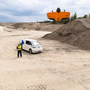
New Study Explores When Drone Mapping Can Reduce Ground Setup A new white paper from Swiss drone manufacturer Wingtra takes on a long-standing question in drone surveying: is it possible to achieve survey-grade accuracy without ground control points (GCPs)? The report, Repeat Accuracy Verification, presents results from 102 drone flights designed to test both accuracy and … [Read more...] about Can You Get Survey-Grade Accuracy Without Ground Control Points?
Blue Marble Shows How AI and LiDAR Deliver ROI for Rail Operators

A New Moment for BVLOS Operations Drone operators in the U.S. now have more access to Beyond Visual Line of Sight (BVLOS) waivers than ever before. These waivers allow a single operator to fly longer routes without placing observers along the entire path. The FAA’s recent publication of the BVLOS Notice of Proposed Rulemaking (NPRM) also marks the first step toward routine … [Read more...] about Blue Marble Shows How AI and LiDAR Deliver ROI for Rail Operators
Blue Marble Geographics Unveils Global Mapper® v26.2 at Intergeo 2025

New update delivers user-driven interface improvements, expanded visualization tools, and enhanced file format support. Blue Marble Geographics has announced the release of Global Mapper® v26.2, the latest version of its all-in-one GIS software. The update was introduced this week at Intergeo 2025, the international mapping conference taking place in Frankfurt, Germany this … [Read more...] about Blue Marble Geographics Unveils Global Mapper® v26.2 at Intergeo 2025


