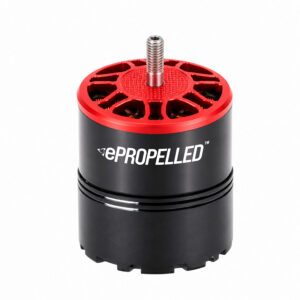
New motor and controller design aims to simplify drone production while improving payload capacity and system reliability ePropelled has introduced a new integrated propulsion system designed to simplify UAV manufacturing and improve aircraft performance. The company unveiled its SKYLARK™ Series at the Farnborough International Airshow 2026, where it positioned the product as … [Read more...] about ePropelled Targets Faster Drone Manufacturing with Integrated SKYLARK Propulsion
Products
Uber-Style Pricing Could Be the Missing Piece for Profitable Air Taxis, Researchers Say

UC Berkeley research presented in Korea finds that dynamic fares could strengthen the business case for airport air taxi service Can Urban Air Mobility (UAM) work? Research presented at Korea Drone and UAM Expo suggests dynamic pricing could make airport air taxis economically viable. While much of the urban air mobility (UAM) conversation has focused on aircraft … [Read more...] about Uber-Style Pricing Could Be the Missing Piece for Profitable Air Taxis, Researchers Say
FAA Highlights First Interstate eVTOL Organ Transport Test Under Integration Pilot Program

BETA Technologies flight demonstrates how electric aircraft could support future medical transport and Advanced Air Mobility operations The Federal Aviation Administration (FAA) has announced a significant milestone for Advanced Air Mobility (AAM). The agency said BETA Technologies and United Therapeutics Corporation completed an interstate flight test using an electric … [Read more...] about FAA Highlights First Interstate eVTOL Organ Transport Test Under Integration Pilot Program
Aerial Triangulation Gets Major Overhaul in SimActive’s Correlator3D Version 11.1

Montreal photogrammetry developer overhauls tie point extraction, bundle adjustment and multi-camera workflows in the latest Correlator3D release. SimActive has released Correlator3D Version 11.1, a photogrammetry update centered on a rebuilt aerial triangulation engine. The company says the release improves tie point extraction, accelerates bundle adjustment and adds tools to … [Read more...] about Aerial Triangulation Gets Major Overhaul in SimActive’s Correlator3D Version 11.1
GeoCue’s TrueView 641 Certified for Real-Time Robotics HERA Drone
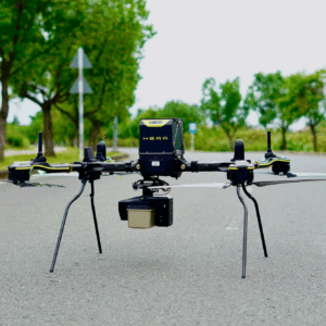
The companies say the integration gives customers a secure aerial mapping option that combines heavy-lift American-made drones with engineering-grade LiDAR. Huntsville, Ala.-based GeoCue has announced that its TrueView LiDAR payloads are now compatible with drones from Real-Time Robotics Inc., a pairing the companies say expands NDAA-compliant drone LiDAR options for customers … [Read more...] about GeoCue’s TrueView 641 Certified for Real-Time Robotics HERA Drone


