• Skip to main content
  • Skip to secondary menu
  • Skip to primary sidebar
  • Skip to secondary sidebar
  • Skip to footer
  • DroneRacingLife
  • DroneFlyers
  • Newsletter
DroneLife

DRONELIFE

Stay up to date on all the latest Drone News

  • News
  • Products
  • Industries
    • Agriculture
    • Construction
    • Delivery
    • Dual Use
    • Inspection
    • Public Safety
    • Surveying
  • Enthusiasts
  • Regulations
  • Business
  • Video
  • Podcasts

What Exactly Can Drone Geospatial Data Do? Disaster Response to Hurricane Michael Provides a Demonstration

November 6, 2018 by Miriam McNabb 4 Comments

Disaster response efforts following Hurricane Michael have showcased high precision drone geospatial data.

SimActive, a world-leading developer of photogrammetry software, partnered with drone service provider Midwest Aerial to perform critical damage assessment of homes and infrastructure after Hurricane Michael struck the Gulf Coast last month.  Hurricane Michael destroyed billions of dollars worth of crops and damaged or destroyed thousands of homes.

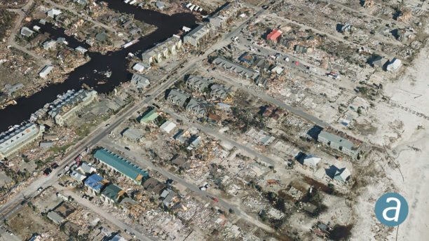
Mexico Beach, Florida, was one of the hardest hit areas.  Suffering a nine-foot storm surge and 155 mph winds, the town of 1, 190 full time residents was absolutely devastated by the storm. Local newspapers called it an “apocalyptic” event, “wiping out” the town.  With most of the homes and roads requiring major restoration, accurate mapping of the area for insurance and rebuilding teams is absolutely critical to getting the town back on its feet.

SimActive is the developer of Correlator3D™ software, a patented end-to-end photogrammetry solution.  What makes SimActive different from many drone mapping solutions is that SimActive offers a platform originally designed for processing geospatial data from satellite imagery for military and large enterprise customers, processing large data sets with precision and speed.  By expanding that platform to also process drone imagery, SimActive makes the same capabilities available for a much larger market.  “Correlator3D™ performs aerial triangulation (AT) and produces dense digital surface models (DSM), digital terrain models (DTM), point clouds, orthomosaics, 3D models and vectorized 3D features,” says SimActive.

Midwest Aerial collected a large quantity of drone aerial data over Mexico Beach: then Correlator3DTM was used to process large format imagery.  The joint effort resulted in highly precise geospatial data, including a DSM, an orthomosaic and a 3D model of the town.

“This is a terrible disaster for the people affected and we hope they can benefit from geospatial technologies available”, said Dr Philippe Simard, President of SimActive.


Miriam McNabb

Miriam McNabb is the Editor-in-Chief of DRONELIFE and CEO of JobForDrones, a professional drone services marketplace, and a fascinated observer of the emerging drone industry and the regulatory environment for drones. Miriam has penned over 3,000 articles focused on the commercial drone space and is an international speaker and recognized figure in the industry.  Miriam has a degree from the University of Chicago and over 20 years of experience in high tech sales and marketing for new technologies.
For drone industry consulting or writing, Email Miriam.

TWITTER:@spaldingbarker

Subscribe to DroneLife here.

Filed Under: Drone News Feeds, Feature 1, News Tagged With: drone mapping, Drones For Good, drones photogrammetry, geospatial data, Midwest Aerial Photography, SimActive

Reader Interactions

Trackbacks

  1. Viral Video of the Persistent Baby Bear Hides a Dark Technological Subtext | Drone "Ki" says:
    December 7, 2018 at 12:07 am

    […] Disaster response efforts following Hurricane Michael have showcased high precision drone geospatial data. SimActive, a world-leading developer of photogrammetry software, partnered with drone service provider Midwest Aerial to perform critical damage assessment of homes and infrastructure after Hurricane Michael struck the Gulf Coast last month.  Hurricane Michael destroyed billions of dollars worth of crops and […] The post What Exactly Can Drone Geospatial Data Do? Disaster Response to HurSee Original Article […]

    Reply
  2. Как использовать геоданные, собранные с помощью дронов? Демонстрация возможностей при стихийных бедствиях на примере урагана Майкл. — FP says:
    November 16, 2018 at 3:58 am

    […] Источник […]

    Reply
  3. What Exactly Can Drone Geospatial Data Do? Disaster Response to Hurricane Michael Provides a Demonstration – Disaster and Recovery says:
    November 7, 2018 at 8:27 pm

    […] For Gooddrones photogrammetrygeospatial dataMidwest Aerial PhotographySimActive Share0 Tweet […]

    Reply
  4. What Exactly Can Drone Geospatial Data Do? Disaster Response to Hurricane Michael Provides a Demonstration - Drones Crunch says:
    November 6, 2018 at 11:11 pm

    […] DRONELIFE […]

    Reply

Leave a Reply Cancel reply

Your email address will not be published. Required fields are marked *

Primary Sidebar

LATEST

FCC Drone Exemption List Offers Clues to Trusted Supplier Requirements

Six months of conditional approvals reveal a broad range of accepted drone applications, while key details of the review process…

Continue Reading FCC Drone Exemption List Offers Clues to Trusted Supplier Requirements

China’s Export Restrictions on Red Cat Highlight a Bigger Challenge for U.S. Drone Manufacturing

Recent Chinese export controls targeting Red Cat may have limited immediate impact, but they underscore why U.S. drone manufacturers are…

Continue Reading China’s Export Restrictions on Red Cat Highlight a Bigger Challenge for U.S. Drone Manufacturing

FAA Modernizes Airspace Management as Demand Grows Across Aviation Sectors

New FAA planning platform aims to improve management of an increasingly complex National Airspace System The Federal Aviation Administration has…

Continue Reading FAA Modernizes Airspace Management as Demand Grows Across Aviation Sectors

SPH Engineering and Vets to Drones Partner to Expand Career Paths for Military Veterans

New training initiative focuses on advanced flight planning skills for surveying, mapping, and inspection work The commercial drone industry continues…

Continue Reading SPH Engineering and Vets to Drones Partner to Expand Career Paths for Military Veterans

FAA Clarifies World Cup Drone Restrictions, Creates Path for Authorized Flights

Commercial Drone Alliance says Part 107 and Part 135 operators now have a path to request approval The FAA is…

Continue Reading FAA Clarifies World Cup Drone Restrictions, Creates Path for Authorized Flights

Drone Scoreboard Debuts Above Seattle World Cup Match

SkyElements displays first drone scoreboard at World Cup By DRONELIFE Features Editor Jim Magill As World Cup fever grips the…

Continue Reading Drone Scoreboard Debuts Above Seattle World Cup Match

More Than 50 Drones Seized Near World Cup Events

Federal officials warn that careless drone operators can face fines, charges, and confiscated aircraft More than 50 drones have been…

Continue Reading More Than 50 Drones Seized Near World Cup Events

Beyond the Primes: Drone Dominance’s First Order Highlights a New Generation of Defense Drone Manufacturers

As the Pentagon’s Drone Dominance Program moves from competition to procurement, emerging drone companies are taking center stage The Department…

Continue Reading Beyond the Primes: Drone Dominance’s First Order Highlights a New Generation of Defense Drone Manufacturers

Fort Worth Takes a Vendor-Neutral Approach to Building Its DFR Program

Fort Worth PD ‘test drives’ vendors’ DFR systems By DRONELIFE Features Editor Jim Magill As police departments across the country…

Continue Reading Fort Worth Takes a Vendor-Neutral Approach to Building Its DFR Program

Taiwan’s Green UAS Milestone Highlights a Potential Path for Trusted Foreign Drone Suppliers

New assessment partnership could help allied manufacturers access the U.S. market while supporting trusted supply chain goals As the United…

Continue Reading Taiwan’s Green UAS Milestone Highlights a Potential Path for Trusted Foreign Drone Suppliers

Secondary Sidebar

Footer

SPONSORED

Inspired Flight Gremsy IF800 VIO F1 drones geo week

What Will It Take to Strengthen U.S. Drone Manufacturing? A Conversation with Inspired Flight’s CEO

Global Mapper Mobile data collection

Collection Ground Control Points with Global Mapper Mobile

Military Drone Mapping Solutions

How SimActive’s Correlator3D™ is Revolutionizing Military Mapping: An Exclusive Interview with CEO Philippe Simard

Photogrammetry Accuracy Standards

SimActive Photogrammetry Software: Enabling Users to Meet Accuracy Standards for Over 20 Years

NACT Engineering Parrot ANAFI tether indoor shot

Smart Tether for Parrot ANAFI USA from NACT Engineering

Blue Marble, features global mapper, features Blue Marble

Check Out These New Features in Global Mapper v25 from Blue Marble

About Us | Contact Us | Advertise With Us | Write for Us | Privacy Policy | Terms of Service

The Trusted Source for the Business of Drones.

This website uses cookies and third party services. By clicking OK, you are agreeing to our privacy policy. ACCEPT

Manage consent

Privacy Overview

This website uses cookies to improve your experience while you navigate through the website. Out of these, the cookies that are categorized as necessary are stored on your browser as they are essential for the working of basic functionalities of the website. We also use third-party cookies that help us analyze and understand how you use this website. These cookies will be stored in your browser only with your consent. You also have the option to opt-out of these cookies. But opting out of some of these cookies may affect your browsing experience.
Necessary
Always Enabled
Necessary cookies are absolutely essential for the website to function properly. These cookies ensure basic functionalities and security features of the website, anonymously.
CookieDurationDescription
cookielawinfo-checkbox-analytics11 monthsThis cookie is set by GDPR Cookie Consent plugin. The cookie is used to store the user consent for the cookies in the category "Analytics".
cookielawinfo-checkbox-functional11 monthsThe cookie is set by GDPR cookie consent to record the user consent for the cookies in the category "Functional".
cookielawinfo-checkbox-necessary11 monthsThis cookie is set by GDPR Cookie Consent plugin. The cookies is used to store the user consent for the cookies in the category "Necessary".
cookielawinfo-checkbox-others11 monthsThis cookie is set by GDPR Cookie Consent plugin. The cookie is used to store the user consent for the cookies in the category "Other.
cookielawinfo-checkbox-performance11 monthsThis cookie is set by GDPR Cookie Consent plugin. The cookie is used to store the user consent for the cookies in the category "Performance".
viewed_cookie_policy11 monthsThe cookie is set by the GDPR Cookie Consent plugin and is used to store whether or not user has consented to the use of cookies. It does not store any personal data.
Functional
Functional cookies help to perform certain functionalities like sharing the content of the website on social media platforms, collect feedbacks, and other third-party features.
Performance
Performance cookies are used to understand and analyze the key performance indexes of the website which helps in delivering a better user experience for the visitors.
Analytics
Analytical cookies are used to understand how visitors interact with the website. These cookies help provide information on metrics the number of visitors, bounce rate, traffic source, etc.
Advertisement
Advertisement cookies are used to provide visitors with relevant ads and marketing campaigns. These cookies track visitors across websites and collect information to provide customized ads.
Others
Other uncategorized cookies are those that are being analyzed and have not been classified into a category as yet.
SAVE & ACCEPT