• Skip to main content
  • Skip to secondary menu
  • Skip to primary sidebar
  • Skip to secondary sidebar
  • Skip to footer
  • DroneRacingLife
  • DroneFlyers
  • Newsletter
DroneLife

DRONELIFE

Stay up to date on all the latest Drone News

  • News
  • Products
  • Industries
    • Agriculture
    • Construction
    • Delivery
    • Dual Use
    • Inspection
    • Public Safety
    • Surveying
  • Enthusiasts
  • Regulations
  • Business
  • Video
  • Podcasts

Ascent’s Coaxial Drones, Now with Exyn’s LiDAR-Enabled Mapping Software

September 23, 2021 by Miriam McNabb 10 Comments

coaxial drones

Partnership to join Ascent’s coaxial drones with Exyn mapping capabilities

By Jim Magill

A partnership, which marries Ascent AeroSystems’ coaxial unmanned aerial system technology with Exyn Technologies’ LiDAR-enabled mapping software, is expected to provide a new solution for customers seeking to operate drone systems in confined spaces and in GPS-denied environments.

The partnership, announced in August, will equip Ascent’s Spirit compact, coaxial aerial platform with Exyn’s LiDAR system and autonomous software stack, enabling the capture of 3D mapping data in environments inaccessible to other UAV systems.

The two companies had been working together for about nine months before announcing their agreement, said Paul Fermo, Ascent’s vice president of business development. Exyn’s software technology creates a three-dimensional LiDAR point cloud that allows operators to build a 3D picture in GPS-denied environments, he said.

“It’s a great technology that’s adaptable to our system, so you have all the benefits of the coaxial drone with the autonomous software stack and LiDAR that Exyn provides,” Fermo said.

He said the two companies hope to expand on the current partnership to develop new drone and software packages as the technology continues to evolve.

“We’re growing our fleet of systems to add both bigger and smaller form factors for the coaxial and I know Exyn is exploring other avenues for development of their technology,” Fermo said. “Our technologies are complementary to each other, so we’re always open to new and better operating capabilities.”

For its part, Exyn Technologies is working to expand its fleet of systems to better work with the new generation of coaxial drones that Ascent is developing, said Exyn’s Chief Technology Officer Jason Derenick.

“They produce state-of-the-art, ruggedized coaxial UAVs that are really built from the ground-up … This partnership reflects the bringing together the best of both worlds to produce something that’s truly unique and industry-leading,” Derenick said.

Making inaccessible data accessible

Founded in 2014 as a spin-out of The University of Pennsylvania’s General Robotics, Automation, Sensing & Perception (GRASP) Lab, Exyn’s technology is focused on “making inaccessible data accessible,” Derenick said. “We do that through two key technologies. The first is mission-level autonomy for autonomous aerial vehicles, as well as high-precision mapping, predominantly in GPS-denied environments.”

Exyn has developed a proprietary software stack, ExynAI, which is platform-agnostic and has been flown in about a dozen different aerial systems. The system is designed to support operations in unstructured environments, especially in environments where there are no persistent communications with the platform and where in many cases, the operators of the platform have no prior information about the environment that they’re exploring.

“It’s very much a self-contained software package that, when fixed to an aerial platform, gives it a high level of autonomy and mapping capabilities,” Derenick said.

Installed on autonomous drones, the Exyn software package is well adapted for use in the mining industry, where it replaces the need for sending human inspectors into potentially dangerous situations.

“Where our systems came in, we could provide two to three orders of magnitude more of information and we could effectively eliminate a person from having to go into these dark, dirty and dangerous cavities,” Derenick said.

The technology can also be employed in the commercial construction industry, autonomously generating high-resolution models of construction projects, which could be imported and compared against a building’s design plan, he said.

“Exyn brings next-generation aerial robotics systems for free-flight exploration of highly complex spaces with no necessity for fallback-ready human operators—at two times the flight speed and with richer data collection than previous standards,” Exyn’s Chief Operating Officer Ben Williams said in a statement announcing the partnership.

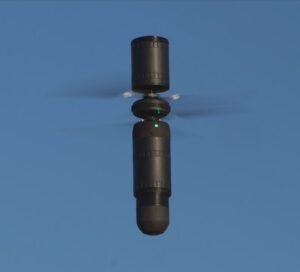
Coaxial drones: design increases lift, endurance

Ascent, which was also established in 2014, is the only manufacturer of enterprise-grade coaxial drones. Unlike more conventional multi-rotor drones, Ascent’s aerial vehicles resemble cylinders with two centrally positioned rotors.

The compact design provides the same performance within a much smaller footprint, compared with a multi-rotor vehicle, Fermo said.

“Without all the arms and external components, it’s a lot more portable, and it’s a lot more rugged,” he said of the coaxial design. The drone’s toughness and versatility make it adaptable for uses in military operations, search and rescue missions and other applications “where an operator might find themself in an austere environment or they might need a system that can overcome bad weather, heavy rains or winds,” he said.

The two large central rotors also provide more lift area than is achieved from four distributed rotor blades in conventional drones. This allows the vehicle to have more payload-weight capacity than multi-rotor vehicles in the same weight class.

“Your rotors spin more slowly, because you’re creating more lift, which means the system is quieter and also more efficient in terms of battery life,” Fermo said. “We also get much better air speed and much better range.”

Ascent says the vehicle can achieve air speeds above 60 mph, “but we’ve actually clocked it at 80 mph,” he said.

The Spirit’s design also increases the drone’s versatility, allowing payloads to be stacked both above and below the vehicle’s core. That gives operators the versatility to upgrade existing payloads or add new ones.

“The cylindrical form factor also gives you the opportunity for new launch modalities and methods: Tube launching, launching out of an aircraft, launching out of a sleeve or recovering with or without landing gear,” Fermo said.

In addition, because it’s narrower from wingtip to wingtip, the coaxial drone is well adapted for industrial applications that require flights within tight spaces, such as inspecting the underside of a highway bridge, he said.

Jim Magill is a Houston-based writer with almost a quarter-century of experience covering technical and economic developments in the oil and gas industry. After retiring in December 2019 as a senior editor with S&P Global Platts, Jim began writing about emerging technologies, such as artificial intelligence, robots and drones, and the ways in which they’re contributing to our society. In addition to DroneLife, Jim is a contributor to Forbes.com and his work has appeared in the Houston Chronicle, U.S. News & World Report, and Unmanned Systems, a publication of the Association for Unmanned Vehicle Systems International.


Miriam McNabb

Miriam McNabb is the Editor-in-Chief of DRONELIFE and CEO of JobForDrones, a professional drone services marketplace, and a fascinated observer of the emerging drone industry and the regulatory environment for drones. Miriam has penned over 3,000 articles focused on the commercial drone space and is an international speaker and recognized figure in the industry.  Miriam has a degree from the University of Chicago and over 20 years of experience in high tech sales and marketing for new technologies.
For drone industry consulting or writing, Email Miriam.

TWITTER:@spaldingbarker

Subscribe to DroneLife here.

Filed Under: Drone News Feeds, News, Products Tagged With: Ascent drones, coaxial drones, drone mapping, Exyn mapping, Security drones

Reader Interactions

Trackbacks

  1. Business UAV Expo Out of doors Flight Demo - blogtecho says:
    September 15, 2022 at 1:00 am

    […] Aerosystems demonstrated their distinctive coaxial drone, Spirit.  Co-axial drones don’t simply look completely different, says Ascent Head of Product Bobby […]

    Reply
  2. Industrial UAV Expo Outside Flight Demo – AI Drone says:
    September 14, 2022 at 5:22 pm

    […] Aerosystems demonstrated their distinctive coaxial drone, Spirit.  Co-axial drones don’t simply look totally different, says Ascent Head of Product Bobby Sakaki. […]

    Reply
  3. Drone-Based LiDAR for Explosive Ordnance Disposal Units – DRONELIFE – DroneLife – Inspection-Detection Pakistan says:
    January 31, 2022 at 11:20 am

    […] LiDAR Systems.To read more about drone-based LiDAR technology, read these previous articles on coaxial drones equipped with LiDAR, micro LiDAR sensors, the differences between LiDAR and photogrammetry, and how LiDAR is used in […]

    Reply
  4. Wireless Power for Drones: Meet the Company Who Wants to Change the Battery Game - Summer Of Drones News says:
    October 15, 2021 at 10:33 am

    […] Read extra on new drone know-how from Jim Magill: Can Batteries Power Urban Air Mobility Flights? and Ascent’s Coaxial Drones, Now with Exyn’s LiDAR-Enabled Mapping Software. […]

    Reply
  5. Drone-Based LiDAR for Explosive Ordnance Disposal Units: More than Mapping | taktik(z) GDI (Government Defense Infrastructure) says:
    October 7, 2021 at 2:33 am

    […] read more about drone-based LiDAR technology, read these previous articles on coaxial drones equipped with LiDAR, micro LiDAR sensors, the differences between LiDAR and photogrammetry, and how LiDAR is used in […]

    Reply
  6. Ascent’s Coaxial Drones, Now with Exyn’s LiDAR-Enabled Mapping Software - DronesOnline.site says:
    September 23, 2021 at 11:51 pm

    […] post Ascent’s Coaxial Drones, Now with Exyn’s LiDAR-Enabled Mapping Software appeared first on […]

    Reply
  7. Ascent’s Coaxial Drones and Exyn’s Mapping – Game Up News says:
    September 23, 2021 at 9:04 pm

    […] Source link […]

    Reply
  8. Ascent’s Coaxial Drones and Exyn’s Mapping – Dronestagram Blog says:
    September 23, 2021 at 4:58 pm

    […] More… […]

    Reply
  9. Ascent’s Coaxial Drones, Now with Exyn’s LiDAR-Enabled Mapping Software – DronePilots.News says:
    September 23, 2021 at 1:23 pm

    […] post Ascent’s Coaxial Drones, Now with Exyn’s LiDAR-Enabled Mapping Software appeared first on […]

    Reply
  10. Ascent’s Coaxial Drones, Now with Exyn’s LiDAR-Enabled Mapping Software | Drone Films Limited says:
    September 23, 2021 at 1:18 pm

    […] post Ascent’s Coaxial Drones, Now with Exyn’s LiDAR-Enabled Mapping Software appeared first on […]

    Reply

Leave a Reply Cancel reply

Your email address will not be published. Required fields are marked *

Primary Sidebar

LATEST

FCC Drone Exemption List Offers Clues to Trusted Supplier Requirements

Six months of conditional approvals reveal a broad range of accepted drone applications, while key details of the review process…

Continue Reading FCC Drone Exemption List Offers Clues to Trusted Supplier Requirements

China’s Export Restrictions on Red Cat Highlight a Bigger Challenge for U.S. Drone Manufacturing

Recent Chinese export controls targeting Red Cat may have limited immediate impact, but they underscore why U.S. drone manufacturers are…

Continue Reading China’s Export Restrictions on Red Cat Highlight a Bigger Challenge for U.S. Drone Manufacturing

FAA Modernizes Airspace Management as Demand Grows Across Aviation Sectors

New FAA planning platform aims to improve management of an increasingly complex National Airspace System The Federal Aviation Administration has…

Continue Reading FAA Modernizes Airspace Management as Demand Grows Across Aviation Sectors

SPH Engineering and Vets to Drones Partner to Expand Career Paths for Military Veterans

New training initiative focuses on advanced flight planning skills for surveying, mapping, and inspection work The commercial drone industry continues…

Continue Reading SPH Engineering and Vets to Drones Partner to Expand Career Paths for Military Veterans

FAA Clarifies World Cup Drone Restrictions, Creates Path for Authorized Flights

Commercial Drone Alliance says Part 107 and Part 135 operators now have a path to request approval The FAA is…

Continue Reading FAA Clarifies World Cup Drone Restrictions, Creates Path for Authorized Flights

Drone Scoreboard Debuts Above Seattle World Cup Match

SkyElements displays first drone scoreboard at World Cup By DRONELIFE Features Editor Jim Magill As World Cup fever grips the…

Continue Reading Drone Scoreboard Debuts Above Seattle World Cup Match

More Than 50 Drones Seized Near World Cup Events

Federal officials warn that careless drone operators can face fines, charges, and confiscated aircraft More than 50 drones have been…

Continue Reading More Than 50 Drones Seized Near World Cup Events

Beyond the Primes: Drone Dominance’s First Order Highlights a New Generation of Defense Drone Manufacturers

As the Pentagon’s Drone Dominance Program moves from competition to procurement, emerging drone companies are taking center stage The Department…

Continue Reading Beyond the Primes: Drone Dominance’s First Order Highlights a New Generation of Defense Drone Manufacturers

Fort Worth Takes a Vendor-Neutral Approach to Building Its DFR Program

Fort Worth PD ‘test drives’ vendors’ DFR systems By DRONELIFE Features Editor Jim Magill As police departments across the country…

Continue Reading Fort Worth Takes a Vendor-Neutral Approach to Building Its DFR Program

Taiwan’s Green UAS Milestone Highlights a Potential Path for Trusted Foreign Drone Suppliers

New assessment partnership could help allied manufacturers access the U.S. market while supporting trusted supply chain goals As the United…

Continue Reading Taiwan’s Green UAS Milestone Highlights a Potential Path for Trusted Foreign Drone Suppliers

Secondary Sidebar

Footer

SPONSORED

Inspired Flight Gremsy IF800 VIO F1 drones geo week

What Will It Take to Strengthen U.S. Drone Manufacturing? A Conversation with Inspired Flight’s CEO

Global Mapper Mobile data collection

Collection Ground Control Points with Global Mapper Mobile

Military Drone Mapping Solutions

How SimActive’s Correlator3D™ is Revolutionizing Military Mapping: An Exclusive Interview with CEO Philippe Simard

Photogrammetry Accuracy Standards

SimActive Photogrammetry Software: Enabling Users to Meet Accuracy Standards for Over 20 Years

NACT Engineering Parrot ANAFI tether indoor shot

Smart Tether for Parrot ANAFI USA from NACT Engineering

Blue Marble, features global mapper, features Blue Marble

Check Out These New Features in Global Mapper v25 from Blue Marble

About Us | Contact Us | Advertise With Us | Write for Us | Privacy Policy | Terms of Service

The Trusted Source for the Business of Drones.

This website uses cookies and third party services. By clicking OK, you are agreeing to our privacy policy. ACCEPT

Manage consent

Privacy Overview

This website uses cookies to improve your experience while you navigate through the website. Out of these, the cookies that are categorized as necessary are stored on your browser as they are essential for the working of basic functionalities of the website. We also use third-party cookies that help us analyze and understand how you use this website. These cookies will be stored in your browser only with your consent. You also have the option to opt-out of these cookies. But opting out of some of these cookies may affect your browsing experience.
Necessary
Always Enabled
Necessary cookies are absolutely essential for the website to function properly. These cookies ensure basic functionalities and security features of the website, anonymously.
CookieDurationDescription
cookielawinfo-checkbox-analytics11 monthsThis cookie is set by GDPR Cookie Consent plugin. The cookie is used to store the user consent for the cookies in the category "Analytics".
cookielawinfo-checkbox-functional11 monthsThe cookie is set by GDPR cookie consent to record the user consent for the cookies in the category "Functional".
cookielawinfo-checkbox-necessary11 monthsThis cookie is set by GDPR Cookie Consent plugin. The cookies is used to store the user consent for the cookies in the category "Necessary".
cookielawinfo-checkbox-others11 monthsThis cookie is set by GDPR Cookie Consent plugin. The cookie is used to store the user consent for the cookies in the category "Other.
cookielawinfo-checkbox-performance11 monthsThis cookie is set by GDPR Cookie Consent plugin. The cookie is used to store the user consent for the cookies in the category "Performance".
viewed_cookie_policy11 monthsThe cookie is set by the GDPR Cookie Consent plugin and is used to store whether or not user has consented to the use of cookies. It does not store any personal data.
Functional
Functional cookies help to perform certain functionalities like sharing the content of the website on social media platforms, collect feedbacks, and other third-party features.
Performance
Performance cookies are used to understand and analyze the key performance indexes of the website which helps in delivering a better user experience for the visitors.
Analytics
Analytical cookies are used to understand how visitors interact with the website. These cookies help provide information on metrics the number of visitors, bounce rate, traffic source, etc.
Advertisement
Advertisement cookies are used to provide visitors with relevant ads and marketing campaigns. These cookies track visitors across websites and collect information to provide customized ads.
Others
Other uncategorized cookies are those that are being analyzed and have not been classified into a category as yet.
SAVE & ACCEPT