• Skip to main content
  • Skip to secondary menu
  • Skip to primary sidebar
  • Skip to secondary sidebar
  • Skip to footer
  • DroneRacingLife
  • DroneFlyers
  • Newsletter
DroneLife

DRONELIFE

Stay up to date on all the latest Drone News

  • News
  • Products
  • Industries
    • Agriculture
    • Construction
    • Delivery
    • Dual Use
    • Inspection
    • Public Safety
    • Surveying
  • Enthusiasts
  • Regulations
  • Business
  • Video
  • Podcasts

UK University Invests in Drones and LiDAR for Forestry Research

January 10, 2018 by Miriam McNabb 11 Comments

COPTRZ LiDAR drone

Researchers at Aberystwyth University in the UK have invested in drone technology to expand their cutting edge forestry research.

The Earth Observation and Ecosystem Dynamics Group at Aberystwyth University in Wales worked with UK-based COPTRZ, a drone sales and consulting firm, to develop a unique LiDAR and spectral imaging solution.

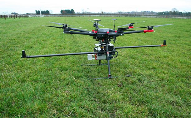
The drone solution will be used to enhance the university’s research by enabling the measurement of standing timber volumes, forest biomass and carbon content.

The Volantä UAV LiDAR system will “enable survey grade point clouds to be captured using a sub 20Kg drone linked to spectral imaging data,” says COPTRZ. “The data captured will then be used to monitor the successful transition of plantation forests to Continuous Cover Forestry, a forest management approach that seeks to increase the ecological diversity of British forests.”

Osian Roberts, PhD Student at Aberystwyth University, explains: “Aberystwyth University owns several fixed-wing and multi-rotor UAVs and we have now added to the fleet with a LiDAR unit that will enable the direct measurement of forest attributes such as tree height, stocking density and canopy cover. We anticipate that the proliferation of UAV technologies over forthcoming years will enhance opportunities for the collection and analysis of remotely sensed data, presenting our students and researchers with an opportunity to increase our knowledge of our environment.”

James Pick, UAV Strategist at COPTRZ and leader of the Volantä LiDAR project, commented, “We are proud to be chosen by Aberystwyth University to enable their drone strategy. The team have been working tirelessly over the past 6 months to develop a UAV LiDAR solution that is both cost-effective and ready to use out of the box. We have managed to deliver this during the project and expect more research departments to consider similar UAV technology in the next 12 months. COPTRZ are looking forward continually working alongside Aberystwyth University in their quest to enhance their global research capabilities.”


Miriam McNabb

Miriam McNabb is the Editor-in-Chief of DRONELIFE and CEO of JobForDrones, a professional drone services marketplace, and a fascinated observer of the emerging drone industry and the regulatory environment for drones. Miriam has penned over 3,000 articles focused on the commercial drone space and is an international speaker and recognized figure in the industry.  Miriam has a degree from the University of Chicago and over 20 years of experience in high tech sales and marketing for new technologies.
For drone industry consulting or writing, Email Miriam.

TWITTER:@spaldingbarker

Subscribe to DroneLife here.

Filed Under: News Tagged With: Commercial Drones, COPTRZ, environmental drones, forestry drones, UK drones

Reader Interactions

Trackbacks

  1. Drones to Manage Powerline Vegetation: Routescene UAV LiDAR says:
    October 12, 2021 at 11:46 am

    […] extra about drones in forestry right here, or extra about drone-based LiDAR right […]

    Reply
  2. Drones to Manage Powerline Vegetation: Routescene UAV LiDAR | taktik(z) GDI (Government Defense Infrastructure) says:
    October 12, 2021 at 12:17 am

    […] more about drones in forestry here, or more about drone-based LiDAR […]

    Reply
  3. Drones to Manage Powerline Vegetation – Global Information on Analytics related news, jobs and training says:
    October 11, 2021 at 9:05 pm

    […] more about drones in forestry here, or more about drone-based LiDAR […]

    Reply
  4. Drones to Manage Powerline Vegetation: Routescene UAV LiDAR - DroneDaddy says:
    October 11, 2021 at 10:09 am

    […] more about drones in forestry here, or more about drone-based LiDAR […]

    Reply
  5. Drones pour gérer la Végétation des Lignes électriques: DRONE Routescene LiDAR - Askell Drone says:
    October 11, 2021 at 10:08 am

    […] savoir plus sur drones en foresterie ici, ou plus sur LiDAR basé sur un drone […]

    Reply
  6. Drones pour gérer la Végétation des Lignes électriques: DRONE Routescene LiDAR | Prestations drones, films institutionnels, journal en ligne says:
    October 11, 2021 at 4:38 am

    […] savoir plus sur drones en foresterie ici, ou plus sur LiDAR basé sur un drone […]

    Reply
  7. Drones to Manage Powerline Vegetation: Routescene UAV LiDAR - Summer Of Drones News says:
    October 10, 2021 at 6:04 pm

    […] extra about drones in forestry right here, or extra about drone-based LiDAR right […]

    Reply
  8. Drones to Manage Powerline Vegetation: Routescene UAV LiDAR - The Drone Page says:
    October 10, 2021 at 5:53 pm

    […] more about drones in forestry here, or more about drone-based LiDAR […]

    Reply
  9. Fortem's DroneHunter Will Down or Capture any Unwanted Drones | Drone "Ki" says:
    February 9, 2018 at 11:59 pm

    […] Researchers at Aberystwyth University in the UK have invested in drone technology to expand their cutting edge forestry research. The Earth Observation and Ecosystem Dynamics Group at Aberystwyth University in Wales worked with UK-based COPTRZ, a drone sales and consulting firm, to develop a unique LiDAR and spectral imaging solution. The drone solution will be […] The post UK University Invests in Drones and LiDAR for Forestry Research appeared first on DRONELIFE. See Original Article […]

    Reply
  10. UK University Invests in Drones and LiDAR for Forestry Research - Royal News 24 says:
    January 11, 2018 at 9:12 pm

    […] Source link […]

    Reply
  11. UK University Invests in Drones and LiDAR for Forestry Research – Dronegram says:
    January 10, 2018 at 10:17 am

    […] post UK University Invests in Drones and LiDAR for Forestry Research appeared first on […]

    Reply

Leave a Reply Cancel reply

Your email address will not be published. Required fields are marked *

Primary Sidebar

LATEST

The Real FCC Drone Debate: Who Controls the Airwaves?

A closer look at how spectrum policy and licensing could determine the future of U.S. drone operations The FCC is…

Continue Reading The Real FCC Drone Debate: Who Controls the Airwaves?

Why Japan’s AAM Roadmap May Be the Most Realistic in the World

A phased, system-wide approach focuses on operations, infrastructure, and public acceptance Japan’s leading AAM provider, SkyDrive, has translated the country’s…

Continue Reading Why Japan’s AAM Roadmap May Be the Most Realistic in the World

DroneShield Opens European Headquarters in Amsterdam Amid Growing Counter-Drone Demand

DroneShield has officially opened its new European headquarters in Amsterdam, The Netherlands. The move strengthens the counter-drone company’s operational presence…

Continue Reading DroneShield Opens European Headquarters in Amsterdam Amid Growing Counter-Drone Demand

Mid-America Transplant Opens 160-Mile Drone Corridor for Organ Donation

Mid-America Transplant has become the first organ procurement organization (OPO) in the United States to use drones for donor blood…

Continue Reading Mid-America Transplant Opens 160-Mile Drone Corridor for Organ Donation

Manna Raises $50M to Expand Drone Delivery Network in the U.S.

Funding supports plans for 40 new bases and continued scaling of suburban UAV delivery operations Manna Air Delivery has announced…

Continue Reading Manna Raises $50M to Expand Drone Delivery Network in the U.S.

Terra Drone Invests in Ukraine-Based Interceptor Drone Company, Launches Terra A1

Partnership aims to scale low-cost defense solutions and expand global unmanned systems capabilities Terra Drone Corporation has announced a strategic…

Continue Reading Terra Drone Invests in Ukraine-Based Interceptor Drone Company, Launches Terra A1

FCC Seeks Input to Advance U.S. Drone Industry

Public notice outlines questions about regulatory reforms, spectrum access, and innovation zones The Federal Communications Commission (FCC) has opened a…

Continue Reading FCC Seeks Input to Advance U.S. Drone Industry

Skyports Deploys Automated BVLOS Drone Surveys for Major German Bridge Project

Remote-operated “drone-in-a-box” system delivers weekly 2D and 3D data for construction monitoring Skyports Drone Services has partnered with HOCHTIEF to…

Continue Reading Skyports Deploys Automated BVLOS Drone Surveys for Major German Bridge Project

Can You Get Survey-Grade Accuracy Without Ground Control Points?

New Study Explores When Drone Mapping Can Reduce Ground Setup A new white paper from Swiss drone manufacturer Wingtra takes…

Continue Reading Can You Get Survey-Grade Accuracy Without Ground Control Points?

April 2026 Public Safety Drone Review: Drones in Remote Environments and Operations on Lanai

DRONELIFE and DRONERESPONDERS host live webcast April 7 at 3 PM EST Register here for the next Public Safety Drone…

Continue Reading April 2026 Public Safety Drone Review: Drones in Remote Environments and Operations on Lanai

Secondary Sidebar

Footer

SPONSORED

Inspired Flight Gremsy IF800 VIO F1 drones geo week

What Will It Take to Strengthen U.S. Drone Manufacturing? A Conversation with Inspired Flight’s CEO

Global Mapper Mobile data collection

Collection Ground Control Points with Global Mapper Mobile

Military Drone Mapping Solutions

How SimActive’s Correlator3D™ is Revolutionizing Military Mapping: An Exclusive Interview with CEO Philippe Simard

Photogrammetry Accuracy Standards

SimActive Photogrammetry Software: Enabling Users to Meet Accuracy Standards for Over 20 Years

NACT Engineering Parrot ANAFI tether indoor shot

Smart Tether for Parrot ANAFI USA from NACT Engineering

Blue Marble, features global mapper, features Blue Marble

Check Out These New Features in Global Mapper v25 from Blue Marble

About Us | Contact Us | Advertise With Us | Write for Us | Privacy Policy | Terms of Service

The Trusted Source for the Business of Drones.

This website uses cookies and third party services. By clicking OK, you are agreeing to our privacy policy. ACCEPT

Manage consent

Privacy Overview

This website uses cookies to improve your experience while you navigate through the website. Out of these, the cookies that are categorized as necessary are stored on your browser as they are essential for the working of basic functionalities of the website. We also use third-party cookies that help us analyze and understand how you use this website. These cookies will be stored in your browser only with your consent. You also have the option to opt-out of these cookies. But opting out of some of these cookies may affect your browsing experience.
Necessary
Always Enabled
Necessary cookies are absolutely essential for the website to function properly. These cookies ensure basic functionalities and security features of the website, anonymously.
CookieDurationDescription
cookielawinfo-checkbox-analytics11 monthsThis cookie is set by GDPR Cookie Consent plugin. The cookie is used to store the user consent for the cookies in the category "Analytics".
cookielawinfo-checkbox-functional11 monthsThe cookie is set by GDPR cookie consent to record the user consent for the cookies in the category "Functional".
cookielawinfo-checkbox-necessary11 monthsThis cookie is set by GDPR Cookie Consent plugin. The cookies is used to store the user consent for the cookies in the category "Necessary".
cookielawinfo-checkbox-others11 monthsThis cookie is set by GDPR Cookie Consent plugin. The cookie is used to store the user consent for the cookies in the category "Other.
cookielawinfo-checkbox-performance11 monthsThis cookie is set by GDPR Cookie Consent plugin. The cookie is used to store the user consent for the cookies in the category "Performance".
viewed_cookie_policy11 monthsThe cookie is set by the GDPR Cookie Consent plugin and is used to store whether or not user has consented to the use of cookies. It does not store any personal data.
Functional
Functional cookies help to perform certain functionalities like sharing the content of the website on social media platforms, collect feedbacks, and other third-party features.
Performance
Performance cookies are used to understand and analyze the key performance indexes of the website which helps in delivering a better user experience for the visitors.
Analytics
Analytical cookies are used to understand how visitors interact with the website. These cookies help provide information on metrics the number of visitors, bounce rate, traffic source, etc.
Advertisement
Advertisement cookies are used to provide visitors with relevant ads and marketing campaigns. These cookies track visitors across websites and collect information to provide customized ads.
Others
Other uncategorized cookies are those that are being analyzed and have not been classified into a category as yet.
SAVE & ACCEPT