
Latest FCC notice suggests Conditional Approval is becoming a long-term compliance framework rather than a temporary exemption program The Federal Communications Commission (FCC) has added two more uncrewed aircraft systems (UAS) to its growing list of devices exempt from the agency's Covered List. But the most significant development may not be the addition of two new … [Read more...] about New FCC Language Reveals Next Phase of Trusted Drone Policy
Commercial Drones
Powerus Expands U.S.-Made Heavy-Lift Drones Into Agriculture
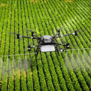
Powerus deals point to growth in U.S., international markets By DRONELIFE Features Editor Jim Magill A Florida-based company that manufactures heavy-lift drones for defense and commercial applications has launched a new agriculture division to market its products in the United State and overseas. Powerus said the new business unit will be operated under the umbrella of its … [Read more...] about Powerus Expands U.S.-Made Heavy-Lift Drones Into Agriculture
Sila’s $300 Million Raise Targets a Critical Weak Link in the U.S. Drone Supply Chain
Funding will support larger-scale silicon anode manufacturing as demand grows across drones, defense, AI, and electric vehicles Sila has raised $300 million in new private funding to expand production of its silicon-carbon battery anode technology in the United States. The investment will help the company increase manufacturing capacity at its Moses Lake, Washington, facility … [Read more...] about Sila’s $300 Million Raise Targets a Critical Weak Link in the U.S. Drone Supply Chain
Mind Over Drone: How Cognitive Load and Pilot Fatigue Are Reshaping Flight Safety
Part 1 of DRONELIFE's Exclusive Series: The Human Edge: People, Perception, and the Future of Drone Operations In this three-part DRONELIFE guest series, transportation and aviation experts Aloha Ley and Giovanni Carnaroli examine the human dimension of drone operations through the lens of current research and operational experience. Rather than focusing solely on technology, … [Read more...] about Mind Over Drone: How Cognitive Load and Pilot Fatigue Are Reshaping Flight Safety
FCC Eyes Next Step in Drone Supply Chain Overhaul With Proposed Sales Ban on Military-Grade Foreign Drones
Agency extends trusted drone exemptions while seeking comment on broader commercial restrictions for certain foreign-made systems The Federal Communications Commission (FCC) is taking another step in its effort to reshape the U.S. drone market. The agency announced Tuesday that it is seeking public comment on whether to prohibit the import, marketing, or sale of certain … [Read more...] about FCC Eyes Next Step in Drone Supply Chain Overhaul With Proposed Sales Ban on Military-Grade Foreign Drones


