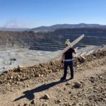
A Czech drone services company, UpVision, has been using UAVs to map the largest copper ore mine in Asia. The mapping mission spanned more than 10km² near the city of Erdenet, Mongolia. In support of Czech geologists investigating the site, the UpVision team deployed a MAVinci Sirius, produced by the German manufacturer acquired by Intel back in 2016. The fixed-wing drone is … [Read more...] about Mapping Asia’s Largest Copper Ore Mine, Using Drones
mapping
Drone Analytics: When to Use Ground Control Points

Guest post DroneDeploy How To Decide If Your Drone Mapping Project Needs GCPs Ground control points (GCPs) can be an invaluable tool for aerial mapping. When used correctly, they help ensure a high degree of global accuracy, which is important for most surveying and construction projects. But the fact is, the majority of drone maps don’t require GCPs. Because of … [Read more...] about Drone Analytics: When to Use Ground Control Points
Parrot Repurposes Consumer Models for Commercial Market
French drone manufacturer Parrot has taken an interesting sideways step into the commercial market this week. The company has announced that two of its latest consumer drones are being repurposed to meet the needs of professionals in agriculture, mapping and inspection, for industries ranging from construction to real estate. Parrot announced that more than a third of its … [Read more...] about Parrot Repurposes Consumer Models for Commercial Market
Black Swift Demonstrates sUAS System for Land Surveys at Extreme Altitudes
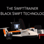
Black Swift Technologies (BST) is a specialized engineering firm based in Boulder that develops turnkey drone surveying systems. They recently conducted a successful survey of deploying a drone at extreme altitudes to capture and deliver geo-referenced digital aerial images. It was an autonomous flight that enabled detailed actionable information to be obtained cost-effectively … [Read more...] about Black Swift Demonstrates sUAS System for Land Surveys at Extreme Altitudes
Accuracy in Drone Mapping: What You Need to Know
Guest post by DroneDeploy Accuracy in Drone Mapping: What You Need to Know Over the last few years, as drone technology has advanced, so too has the ability for drone maps to be highly accurate. But what exactly do we mean when we talk about accuracy in drone mapping? Is it always important for a map to be highly accurate? And what range of accuracy can you … [Read more...] about Accuracy in Drone Mapping: What You Need to Know


