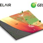
French enterprise drone manufacturer and aerial data provider Delair and Geosys, a specialist in satellite and weather data analytics for agriculture, have announced a partnership to expand data gathering and analysis in precision farming. The result of the partnership will be a single analytics platform that integrates drone and satellite data for agriculture companies … [Read more...] about Delair and Geosys Partner on Precision Agriculture
mapping
SETI Institute Drone Maps Iceland Lava Cave in Preparation for Mars and Moon Exploration
The SETI Institute is probably best known for its work scanning the stars for signs of extraterrestrial communications. But the organization's remit is broader than that. Its many research teams work towards a noble goal: to explore, understand, and explain the origin and nature of life in the universe. Exploring other planets isn't a task to be taken lightly. Equipment and … [Read more...] about SETI Institute Drone Maps Iceland Lava Cave in Preparation for Mars and Moon Exploration
Astigan: Ordnance Survey To Launch High-Altitude, Solar-Powered Mapping Drone

National mapping agency for Great Britain and leading geospatial data organization Ordnance Survey (OS) has announced plans to launch a solar-powered drone that will fly at high altitude to complement existing satellite mapping systems. The aim of the High Altitude Psuedo Satellite (HAPS) project, called Astigan, is to provide faster, higher quality images of Earth from … [Read more...] about Astigan: Ordnance Survey To Launch High-Altitude, Solar-Powered Mapping Drone
SimActive expands further into Asia via fast growing South Korea
SimActive Inc., a world-leading developer of photogrammetry software, announced in a press release today that it enabled the first government drone mapping project in South Korea. Asia Aero Survey (AAS), a SimActive regional partner, used Correlator3D™ for the public survey delivered to the Korean National Geographic Information Institute (NGII) and the Korean Association of … [Read more...] about SimActive expands further into Asia via fast growing South Korea
A Closer Look at senseFly’s New eBee X

Amid the avalanche of product and service launches, partnership announcements and general industry news at Interdrone earlier this month, senseFly, a division of French drone manufacturer Parrot, unveiled a new modular drone for aerial mapping and surveying. On paper, the eBee X looks like a useful fixed-wing aircraft that should provide a rugged and adaptable solution for a … [Read more...] about A Closer Look at senseFly’s New eBee X


