• Skip to main content
  • Skip to secondary menu
  • Skip to primary sidebar
  • Skip to secondary sidebar
  • Skip to footer
  • DroneRacingLife
  • DroneFlyers
  • Newsletter
DroneLife

DRONELIFE

Stay up to date on all the latest Drone News

  • News
  • Products
  • Industries
    • Agriculture
    • Construction
    • Delivery
    • Dual Use
    • Inspection
    • Public Safety
    • Surveying
  • Enthusiasts
  • Regulations
  • Business
  • Video
  • Podcasts

SETI Institute Drone Maps Iceland Lava Cave in Preparation for Mars and Moon Exploration

March 21, 2019 by Malek Murison 6 Comments

The SETI Institute is probably best known for its work scanning the stars for signs of extraterrestrial communications. But the organization’s remit is broader than that. Its many research teams work towards a noble goal: to explore, understand, and explain the origin and nature of life in the universe.

Exploring other planets isn’t a task to be taken lightly. Equipment and methodology have to be perfected well ahead of time. The SETI Institute and Astrobotic Technology this week revealed that they have used a drone to successfully map an ‘ice-rich lava tube’ (also known as a cave) in Iceland.

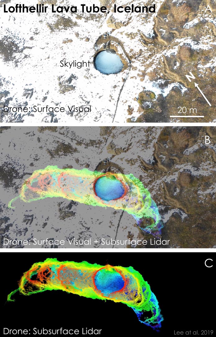
The team generated a 3D map of the Lofthellir Lava Tube Ice Cave in the remote Myvatn region of Iceland. From the data gathered they now know the caves shape, size and depth, and also have a good idea of its history. With a drone and a LiDAR system, they learned all the secrets of this isolated cave’s rock falls and ice formations.

The mission is being touted as a proof-of-concept for the use of drones to explore and document the terrain of other planets, including Mars and our own Moon.

The field team was led by SETI Institute planetary scientist Pascal Lee. “We went to Iceland to study a lava tube with massive amounts of ice inside it to understand better both the potential hazards and opportunities presented by the many lava caves we hope to explore on the Moon and Mars,” he said. “One promising way to explore them is with drones.”

Drone-LiDAR mapping of the “skylight” entrance area of the Lofthellir Lava Tube Ice Cave in Iceland.
Figure 1: Drone-LiDAR mapping of the “skylight” entrance area of the Lofthellir Lava Tube Ice Cave in Iceland. Top: Aerial view of the entrance. Bottom: Drone-borne LiDAR map of the lava tube cave below the skylight entrance area. Middle: Drone LiDAR map projected against the aerial view to show underground extent of lava tube entrance area. (Credit: NASA/Astrobotic/SETI Institute/Lee et al. 2019)

Cave exploration: Another example of drones providing insight in inaccessible places

We’ve seen before how drones can handle operations in dangerous and hard-to-reach locations. SETI’s plan was to show how that capability can be taken to the next level.

Exploring underground environments in other worlds is a priority for researchers. Both the Moon and Mars have cave openings on their surface, each one of which houses an environment that’s been sheltered from the harsh conditions prevailing at the surface, temperature swings, radiation and micrometeorite bombardment from space.

These sheltered spots are obvious places to look for signs of life. They have also been proposed as natural shelters that future human explorers could use for storage, short-term stays, and, if Elon Musk gets his way, colonization.

Astrobotic's LiDAR-equipped drone inside Main Chamber of the Lofthellir Lava Tube Ice Cave in Iceland
Figure 2: Astrobotic’s LiDAR-equipped drone on the floor of the Main Chamber of the Lofthellir Lava Tube Ice Cave in Iceland, ready for its subterranean mapping mission. (Credit: NASA/Astrobotic/SETI Institute/Dubai Future Foundation/Lee et al. 2019)

All that’s needed is an aerial system capable of navigating what would be an incredibly treacherous environment for a human explorer.

“Small free-flying spacecraft might be the ideal robotic platform for the exploration of lava tubes on Earth, the Moon, and Mars for the simple reason that they would not need to come in direct contact with any of the rough and potentially unstable surfaces found inside caves and lava tubes,” says Andrew Horchler, Director of Future Missions and Technology at Astrobotic, the private space company developing the drone-based LiDAR mapping technology. “Nimble drones could enter, map, and exit caves quickly, returning from the darkness to send data back to Earth, return a sample to the surface, recharge and refuel.”

Read more: 50 Ways to Love Your LiDAR: How LiDAR is Used in Commercial Drone Applications

Using LiDAR and Stereo Vision to Navigate Without GPS

Drones on the Moon would have to be specially adapted. As there is practically no atmosphere, any drone would rely on small thrusters rather than conventional props. They would also need sophisticated navigation tools, such as the LiDAR proven in the Iceland mission.

NASA and Astrobotic’s LiDAR and stereo vision navigation system, AstroNav, gave the drone the ability to autonomously explore and map the subterranean environment. It relies on both stereo vision and LiDAR, works without GPS or previously stored maps, and can operate in real-time.

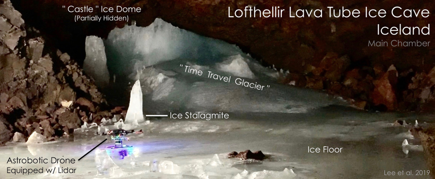
“The Astrobotic drone and LiDAR performed exactly as we had hoped, and was able to help us map the Lofthellir Lava Tube in 3D within minutes” says Lee. “We now have a highly accurate model of the shape and dimensions of the cave, and of the configuration of its many rocky and icy features, such as rock falls, ice columns, and micro-glaciers.”

The project represents a first for researchers. “More development work will be needed to create a system that’s ready for the Moon or Mars, but the study of this icy lava tube is an important first step for us” said Horchler.

The project was supported by NASA, the Mars Institute, and a Mohammed bin Rashid Space Settlement Challenge grant from the Dubai Future Foundation.

Malek Murison
Malek Murison

Malek Murison is a freelance writer and editor with a passion for tech trends and innovation. He handles product reviews, major releases and keeps an eye on the enthusiast market for DroneLife.
Email Malek
Twitter:@malekmurison

Subscribe to DroneLife here.

Filed Under: Drone News, Enthusiasts, Featured - Mining, Mining and Aggregates, News, Technology Tagged With: 3d model, cave, exploration, GPS, Iceland, LIDAR, mapping, navigation, seti institute

Reader Interactions

Trackbacks

  1. ORCA Hub Unveils Autonomous Drones for Offshore Energy Industry – Air and Ground says:
    October 15, 2019 at 6:32 am

    […] Read more: SETI Institute Drone Maps Iceland Lava Cave in Preparation for Mars and Moon Exploration […]

    Reply
  2. SETI Institute Drone Maps Iceland Lava Cave in Preparation for Mars and Moon Exploration | News and Reviews about Drones, Quadcopter, Camera says:
    March 24, 2019 at 7:21 am

    […] Source link […]

    Reply
  3. SETI Institute Drone Maps Iceland Lava Cave in Preparation for Mars and Moon Exploration – Top Drones & reviews says:
    March 21, 2019 at 11:10 pm

    […] post SETI Institute Drone Maps Iceland Lava Cave in Preparation for Mars and Moon Exploration appeared first on […]

    Reply
  4. SETI Institute Drone Maps Iceland Lava Cave in Preparation for Mars and Moon Exploration says:
    March 21, 2019 at 2:33 pm

    […] post SETI Institute Drone Maps Iceland Lava Cave in Preparation for Mars and Moon Exploration appeared first on […]

    Reply
  5. SETI Institute Drone Maps Iceland Lava Cave in Preparation for Mars and Moon Exploration | Drone Magazine says:
    March 21, 2019 at 9:13 am

    […] Source […]

    Reply
  6. SETI Institute Drone Maps Iceland Lava Cave in Preparation for Mars and Moon Exploration - Drones Crunch says:
    March 21, 2019 at 8:37 am

    […] DRONELIFE […]

    Reply

Leave a Reply Cancel reply

Your email address will not be published. Required fields are marked *

Primary Sidebar

LATEST

Who Builds the Sky? How Regional Partnerships Are Creating the Infrastructure for Advanced Air Mobility

On this episode of the Drone Radio Show, Lavera Alexander of the Monterey Bay Economic Partnership discusses why the future…

Continue Reading Who Builds the Sky? How Regional Partnerships Are Creating the Infrastructure for Advanced Air Mobility

FAA Moves from Planning to Building for Advanced Air Mobility

New research facility signals shift from policy development to operational readiness The Federal Aviation Administration is taking another step toward…

Continue Reading FAA Moves from Planning to Building for Advanced Air Mobility

How Skyways Quietly Built a Global Heavy-Lift Drone Business

Texas-based company expands offshore cargo operations while preparing for the next phase of U.S. BVLOS regulations By DRONELIFE Features Editor…

Continue Reading How Skyways Quietly Built a Global Heavy-Lift Drone Business

National Resilience Strategy Connects the Dots Behind U.S. Drone Policy

New White House strategy frames commercial drones as part of a broader effort to strengthen U.S. manufacturing, infrastructure, and supply…

Continue Reading National Resilience Strategy Connects the Dots Behind U.S. Drone Policy

Beyond the Drone: Percepto’s New Platform Brings AI to Infrastructure Inspections

Percepto launches next-gen inspection software By DRONELIFE Features Editor Jim Magill For energy companies, producing actionable data is almost as…

Continue Reading Beyond the Drone: Percepto’s New Platform Brings AI to Infrastructure Inspections

Danish Investigation Finds No Proof Drones Caused Copenhagen Airport Shutdown

Nine-month investigation underscores the need for better airspace awareness, not just more speculation News and Commentary.  A nine-month investigation into…

Continue Reading Danish Investigation Finds No Proof Drones Caused Copenhagen Airport Shutdown

Flytrex and Wing Report Zero Airspace Conflicts for Multi-Operator Drone Delivery

Flytrex says automated UTM coordination with Wing has deconflicted 100% of operations in Dallas–Fort Worth shared airspace, with zero conflicts.…

Continue Reading Flytrex and Wing Report Zero Airspace Conflicts for Multi-Operator Drone Delivery

BRINC Partnership Gives Public Safety Agencies an “Immediate Upgrade” in Incident Intelligence

BRINC and Nova Partner to Add Advanced Mapping and Thermal Intelligence for Public Safet Public safety drone manufacturer BRINC has…

Continue Reading BRINC Partnership Gives Public Safety Agencies an “Immediate Upgrade” in Incident Intelligence

Prodrone Debuts All-Japanese Industrial Drone

This article published in collaboration with JUIDA, the Japan UAS Industrial Development Association.     Aichi-based Prodrone introduces the PD4B-MS prototype,…

Continue Reading Prodrone Debuts All-Japanese Industrial Drone

Uruguayan Government Announces New Drone Dispatch Program

The Montevideo deployment, run in partnership with Uruguayan technology firm Timerix, ties gunshot-detection alerts to automated drone dispatch and live…

Continue Reading Uruguayan Government Announces New Drone Dispatch Program

Secondary Sidebar

Footer

SPONSORED

Inspired Flight Gremsy IF800 VIO F1 drones geo week

What Will It Take to Strengthen U.S. Drone Manufacturing? A Conversation with Inspired Flight’s CEO

Global Mapper Mobile data collection

Collection Ground Control Points with Global Mapper Mobile

Military Drone Mapping Solutions

How SimActive’s Correlator3D™ is Revolutionizing Military Mapping: An Exclusive Interview with CEO Philippe Simard

Photogrammetry Accuracy Standards

SimActive Photogrammetry Software: Enabling Users to Meet Accuracy Standards for Over 20 Years

NACT Engineering Parrot ANAFI tether indoor shot

Smart Tether for Parrot ANAFI USA from NACT Engineering

Blue Marble, features global mapper, features Blue Marble

Check Out These New Features in Global Mapper v25 from Blue Marble

About Us | Contact Us | Advertise With Us | Write for Us | Privacy Policy | Terms of Service

The Trusted Source for the Business of Drones.

This website uses cookies and third party services. By clicking OK, you are agreeing to our privacy policy. ACCEPT

Manage consent

Privacy Overview

This website uses cookies to improve your experience while you navigate through the website. Out of these, the cookies that are categorized as necessary are stored on your browser as they are essential for the working of basic functionalities of the website. We also use third-party cookies that help us analyze and understand how you use this website. These cookies will be stored in your browser only with your consent. You also have the option to opt-out of these cookies. But opting out of some of these cookies may affect your browsing experience.
Necessary
Always Enabled
Necessary cookies are absolutely essential for the website to function properly. These cookies ensure basic functionalities and security features of the website, anonymously.
CookieDurationDescription
cookielawinfo-checkbox-analytics11 monthsThis cookie is set by GDPR Cookie Consent plugin. The cookie is used to store the user consent for the cookies in the category "Analytics".
cookielawinfo-checkbox-functional11 monthsThe cookie is set by GDPR cookie consent to record the user consent for the cookies in the category "Functional".
cookielawinfo-checkbox-necessary11 monthsThis cookie is set by GDPR Cookie Consent plugin. The cookies is used to store the user consent for the cookies in the category "Necessary".
cookielawinfo-checkbox-others11 monthsThis cookie is set by GDPR Cookie Consent plugin. The cookie is used to store the user consent for the cookies in the category "Other.
cookielawinfo-checkbox-performance11 monthsThis cookie is set by GDPR Cookie Consent plugin. The cookie is used to store the user consent for the cookies in the category "Performance".
viewed_cookie_policy11 monthsThe cookie is set by the GDPR Cookie Consent plugin and is used to store whether or not user has consented to the use of cookies. It does not store any personal data.
Functional
Functional cookies help to perform certain functionalities like sharing the content of the website on social media platforms, collect feedbacks, and other third-party features.
Performance
Performance cookies are used to understand and analyze the key performance indexes of the website which helps in delivering a better user experience for the visitors.
Analytics
Analytical cookies are used to understand how visitors interact with the website. These cookies help provide information on metrics the number of visitors, bounce rate, traffic source, etc.
Advertisement
Advertisement cookies are used to provide visitors with relevant ads and marketing campaigns. These cookies track visitors across websites and collect information to provide customized ads.
Others
Other uncategorized cookies are those that are being analyzed and have not been classified into a category as yet.
SAVE & ACCEPT