• Skip to main content
  • Skip to secondary menu
  • Skip to primary sidebar
  • Skip to secondary sidebar
  • Skip to footer
  • DroneRacingLife
  • DroneFlyers
  • Newsletter
DroneLife

DRONELIFE

Stay up to date on all the latest Drone News

  • News
  • Products
  • Industries
    • Agriculture
    • Construction
    • Delivery
    • Dual Use
    • Inspection
    • Public Safety
    • Surveying
  • Enthusiasts
  • Regulations
  • Business
  • Video
  • Podcasts

Astigan: Ordnance Survey To Launch High-Altitude, Solar-Powered Mapping Drone

February 13, 2019 by Malek Murison 9 Comments

National mapping agency for Great Britain and leading geospatial data organization Ordnance Survey (OS) has announced plans to launch a solar-powered drone that will fly at high altitude to complement existing satellite mapping systems.

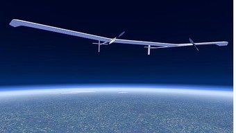
The aim of the High Altitude Psuedo Satellite (HAPS) project, called Astigan, is to provide faster, higher quality images of Earth from 67,000 ft – almost twice the cruising altitude of a commercial airliner.

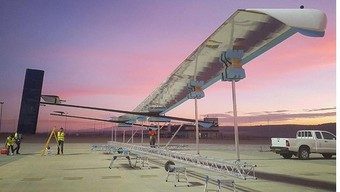
The platform weighs just 149kg and has a wingspan of 38 meters. Much like Airbus’ record-breaking solar-powered drone, the intention is for Astigan to be a middle ground between conventional satellite systems and your average UAVs.

Eventually, it will fly for 90 days at a time without needing to land – enough time to circle Earth four-and-a-half times.

Positive news for UK tech amid Brexit uncertainty

Plenty of businesses are holding off on big investment decisions or leaving the UK entirely amid the uncertainty of Brexit. The project’s progress is a rare nugget of positive news for the UK Government.

Business Minister Lord Henley said, “The UK has a particularly successful track record in mapping and associated technology. This exciting new unmanned aircraft project is a brilliant example of the innovative thinking behind our modern Industrial Strategy and should lead to global business opportunities.

“As well as having the potential to support key government objectives such as upgrading the UK’s infrastructure, it could benefit emerging technology areas such as smart cities and self-driving vehicles which both rely on accurate 3D mapping.”

Since 2014, the Astigan project has collaborated with a range of British SMEs, industry experts and universities. Eight full scale flights have already been completed. The Astigan team says it has the potential to work alongside existing mapping capabilities to revolutionise the speed, accuracy and cost involved in mapping a country.

astigan high altitude drone ordnance survey
Astigan high-altitude Earth observation platform on the ground

Astigan’s ambitious development targets

Brian Jones, Astigan Managing Director, has confirmed that full testing and endurance flights will take place later this year.

“This remarkable aircraft has met every goal and passed all milestones in its ambitious development programme so far,” he said. “We are excited about the year ahead as we increase our flights and move towards a fully operational high-altitude test. By the end of 2019 we aim to be completing endurance flight testing, building up to 90 days non-stop, which is the operational capability we’re striving for.

“It’s incredibly exciting that the UK has developed this kind of technology, delivering satellite capabilities, unparalleled flexibility and improved efficiency, all at a vastly reduced cost. We look forward to completing this project and seeing the aircraft deliver on its outstanding potential, which should provide a range of scientific and environmental benefits.”

Beyond mapping

Geospatial data and mapping derived from aerial imagery capture is only one example of Astigan’ potential. The team also says the technology can be used for climate and environmental monitoring, keeping a close eye on the polar ice caps or deforestation, for example. It could also provide localized and persistent early warning, observation and communications from high above natural disasters.

Astigan high-altitude Earth observation platform in flight

Neil Ackroyd, a Co-Founding Director of Astigan and Acting CEO of Ordnance Survey, said: “Astigan is another example of OS being at the forefront of geospatial technology. The platform has been designed to offer major cost and efficiency advantages over traditional methods. The company has produced a unique, British-made platform which can carry a range of interchangeable earth observation instruments such as high-precision cameras, atmospheric monitoring systems and multi-spectral sensors.

“Astigan supports Ordnance Survey in enhancing its capabilities to work in partnership with other nations across the globe. By aligning this capability with our world-class geospatial production and mapping expertise, we hope to support organisations and countries in tackling major societal challenges including urbanisation, land management, environmental change and mapping to support emergency response in the case of natural disasters.”

Malek Murison
Malek Murison

Malek Murison is a freelance writer and editor with a passion for tech trends and innovation. He handles product reviews, major releases and keeps an eye on the enthusiast market for DroneLife.
Email Malek
Twitter:@malekmurison

Subscribe to DroneLife here.

Filed Under: Aerospace, Business and Finance, Drone News Feeds, Enthusiasts, Fixed wing, Imaging, News, Technology Tagged With: astigan, HAPS, mapping, ordnance survey, solar power, UK

Reader Interactions

Trackbacks

  1. Dual-Use Drone Tech Military Commercial Cross Over - Drones R Us says:
    June 1, 2022 at 7:33 am

    […] early-stage example is Global Hawk – a high-altitude/high-endurance UAV, which was developed in the mid- 90’s with a consortium consisting of DARPA (lead technology […]

    Reply
  2. दोहरे उपयोग वाली ड्रोन तकनीक: सैन्य और वाणिज्यिक अनुप्रयोगों के बीच की खाई को पाटना India October 2021 - Visit हि says:
    October 4, 2021 at 5:59 am

    […] चरण का उदाहरण है ग्लोबल हॉक – ए उच्च-ऊंचाई/उच्च-धीरज यूएवी, जिसे 90 के दशक के मध्य में एक […]

    Reply
  3. Dual-Use Drone Technology: Closing the Gap Between Military and Commercial Applications | Prestations drones, films institutionnels, journal en ligne says:
    September 30, 2021 at 11:20 pm

    […] early-stage example is Global Hawk – a high-altitude/high-endurance UAV, which was developed in the mid- 90’s with a consortium consisting of DARPA (lead technology […]

    Reply
  4. Dual-Use Drone Technology: Closing the Gap Between Military and Commercial Applications | taktik(z) GDI (Government Defense Infrastructure) says:
    September 30, 2021 at 5:51 pm

    […] early-stage example is Global Hawk – a high-altitude/high-endurance UAV, which was developed in the mid- 90’s with a consortium consisting of DARPA (lead technology […]

    Reply
  5. Dual-Use Drone Technology: Closing the Gap Between Military and Commercial Applications - Summer Of Drones News says:
    September 30, 2021 at 11:52 am

    […] early-stage instance is Global Hawk – a high-altitude/high-endurance UAV, which was developed within the mid- 90’s with a consortium consisting of DARPA (lead technology […]

    Reply
  6. Dual-Use Drone Technology: Closing the Gap Between Military and Commercial Applications - The Drone Page says:
    September 30, 2021 at 11:16 am

    […] early-stage example is Global Hawk – a high-altitude/high-endurance UAV, which was developed in the mid- 90’s with a consortium consisting of DARPA (lead technology […]

    Reply
  7. Astigan: Ordnance Survey To Launch High-Altitude, Solar-Powered Mapping Drone says:
    February 13, 2019 at 3:36 pm

    […] post Astigan: Ordnance Survey To Launch High-Altitude, Solar-Powered Mapping Drone appeared first on […]

    Reply
  8. Astigan: Ordnance Survey To Launch High-Altitude, Solar-Powered Mapping Drone - Drones Crunch says:
    February 13, 2019 at 11:47 am

    […] DRONELIFE […]

    Reply
  9. Astigan: Ordnance Survey To Launch High-Altitude, Solar-Powered Mapping Drone | Drone Magazine says:
    February 13, 2019 at 7:50 am

    […] Source […]

    Reply

Leave a Reply Cancel reply

Your email address will not be published. Required fields are marked *

Primary Sidebar

LATEST

Sweden’s Everdrone Opens Borås Base for Defibrillator Drone Deliveries

Sweden’s Västra Götaland Region adds a fourth E3 base, extending Everdrone’s autonomous AED network to roughly 300,000 residents. The Västra…

Continue Reading Sweden’s Everdrone Opens Borås Base for Defibrillator Drone Deliveries

Near Earth Autonomy Wins MARV-EL Contract for Marine Corps Logistics Drone

Naval Air Systems Command picks the Pittsburgh autonomy specialist to build an uncrewed Bell 505 with Bell Textron, Moog, and…

Continue Reading Near Earth Autonomy Wins MARV-EL Contract for Marine Corps Logistics Drone

Elistair Khronos Tethered Drone Joins France’s ORION 2026 Exercise

The automated DroneBox provides persistent aerial surveillance during NATO-style multi-domain operations involving 12,500 troops and 1,200 drones. Elistair’s Khronos automated…

Continue Reading Elistair Khronos Tethered Drone Joins France’s ORION 2026 Exercise

New Senate Bill Targets Drone Threats to Critical Infrastructure

Senate Bill Seeks to Expand Counter-UAS Authority at Critical Infrastructure SitesLegislation outlines authority, training, and funding as drone threats gain…

Continue Reading New Senate Bill Targets Drone Threats to Critical Infrastructure

Can Drones Replace High-Speed Police Pursuits? BRINC’s Guardian Points to a New Model

At the recent Motorola Solutions [NYSE: MSI], BRINC CEO Blake Resnick outlined a vision that challenges one of policing’s most…

Continue Reading Can Drones Replace High-Speed Police Pursuits? BRINC’s Guardian Points to a New Model

Can America Build a Fully Domestic Drone? Lithium Discovery Moves the Needle

New USGS findings highlight potential for domestic lithium supply, but key gaps remain in the battery chain A new study…

Continue Reading Can America Build a Fully Domestic Drone? Lithium Discovery Moves the Needle

Public Safety Drone Review: May 5, 2026 with BRINC CEO Blake Resnick

Join the Live Discussion on May 5 Register here for the May Public Safety Drone Review. The next Public Safety…

Continue Reading Public Safety Drone Review: May 5, 2026 with BRINC CEO Blake Resnick

Lawmakers Urge Expanded National Guard Role for Drone Security at 2026 FIFA World Cup

Letter calls for unified federal approach to counter-UAS operations across U.S. host cities U.S. lawmakers are calling on the federal…

Continue Reading Lawmakers Urge Expanded National Guard Role for Drone Security at 2026 FIFA World Cup

Skydio Raises $110M Series F, Signals Strong Revenue and U.S. Manufacturing Push

CEO Adam Bry highlights reduced capital needs as company expands production and commits billions to domestic manufacturing Skydio has raised…

Continue Reading Skydio Raises $110M Series F, Signals Strong Revenue and U.S. Manufacturing Push

Teledyne FLIR Defense Expands Payload Program with Emesent Hovermap for GPS-Denied Operations

New integration brings LiDAR mapping and radiation detection together across air and ground platforms Teledyne FLIR Defense has expanded its…

Continue Reading Teledyne FLIR Defense Expands Payload Program with Emesent Hovermap for GPS-Denied Operations

Secondary Sidebar

Footer

SPONSORED

Inspired Flight Gremsy IF800 VIO F1 drones geo week

What Will It Take to Strengthen U.S. Drone Manufacturing? A Conversation with Inspired Flight’s CEO

Global Mapper Mobile data collection

Collection Ground Control Points with Global Mapper Mobile

Military Drone Mapping Solutions

How SimActive’s Correlator3D™ is Revolutionizing Military Mapping: An Exclusive Interview with CEO Philippe Simard

Photogrammetry Accuracy Standards

SimActive Photogrammetry Software: Enabling Users to Meet Accuracy Standards for Over 20 Years

NACT Engineering Parrot ANAFI tether indoor shot

Smart Tether for Parrot ANAFI USA from NACT Engineering

Blue Marble, features global mapper, features Blue Marble

Check Out These New Features in Global Mapper v25 from Blue Marble

About Us | Contact Us | Advertise With Us | Write for Us | Privacy Policy | Terms of Service

The Trusted Source for the Business of Drones.

This website uses cookies and third party services. By clicking OK, you are agreeing to our privacy policy. ACCEPT

Manage consent

Privacy Overview

This website uses cookies to improve your experience while you navigate through the website. Out of these, the cookies that are categorized as necessary are stored on your browser as they are essential for the working of basic functionalities of the website. We also use third-party cookies that help us analyze and understand how you use this website. These cookies will be stored in your browser only with your consent. You also have the option to opt-out of these cookies. But opting out of some of these cookies may affect your browsing experience.
Necessary
Always Enabled
Necessary cookies are absolutely essential for the website to function properly. These cookies ensure basic functionalities and security features of the website, anonymously.
CookieDurationDescription
cookielawinfo-checkbox-analytics11 monthsThis cookie is set by GDPR Cookie Consent plugin. The cookie is used to store the user consent for the cookies in the category "Analytics".
cookielawinfo-checkbox-functional11 monthsThe cookie is set by GDPR cookie consent to record the user consent for the cookies in the category "Functional".
cookielawinfo-checkbox-necessary11 monthsThis cookie is set by GDPR Cookie Consent plugin. The cookies is used to store the user consent for the cookies in the category "Necessary".
cookielawinfo-checkbox-others11 monthsThis cookie is set by GDPR Cookie Consent plugin. The cookie is used to store the user consent for the cookies in the category "Other.
cookielawinfo-checkbox-performance11 monthsThis cookie is set by GDPR Cookie Consent plugin. The cookie is used to store the user consent for the cookies in the category "Performance".
viewed_cookie_policy11 monthsThe cookie is set by the GDPR Cookie Consent plugin and is used to store whether or not user has consented to the use of cookies. It does not store any personal data.
Functional
Functional cookies help to perform certain functionalities like sharing the content of the website on social media platforms, collect feedbacks, and other third-party features.
Performance
Performance cookies are used to understand and analyze the key performance indexes of the website which helps in delivering a better user experience for the visitors.
Analytics
Analytical cookies are used to understand how visitors interact with the website. These cookies help provide information on metrics the number of visitors, bounce rate, traffic source, etc.
Advertisement
Advertisement cookies are used to provide visitors with relevant ads and marketing campaigns. These cookies track visitors across websites and collect information to provide customized ads.
Others
Other uncategorized cookies are those that are being analyzed and have not been classified into a category as yet.
SAVE & ACCEPT