
New LiveOps layers integrate NOAA fire and smoke data to give public safety agencies a more complete operational picture
BRINC has added wildfire and smoke tracking to its LiveOps platform, giving public safety agencies another source of information during active fire response.
The company announced two new map layers on August 10. The features display active fire detections and current smoke conditions alongside drone operations, live video, and other incident information.
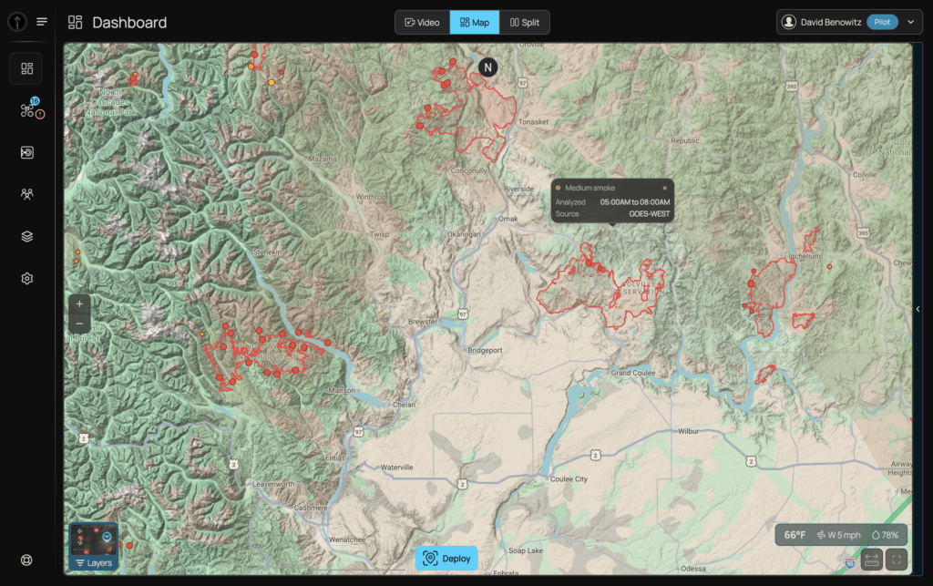
BRINC made the new layers available to all customers on August 7 at no additional cost.
Bringing Fire Data Into Drone Operations
The new features use data from the National Oceanic and Atmospheric Administration (NOAA). Agencies can turn the fire and smoke layers on or off independently.
The goal is to give responders a more complete operational picture without requiring them to switch between separate systems.
Fire departments and emergency managers can use the information while assessing and coordinating wildfire response. Law enforcement agencies can also view smoke conditions when reduced visibility affects operations in impacted communities.
“When agencies are stretched thin responding to wildfires, the last thing they need is another screen to check,” said Blake Resnick, BRINC Founder and CEO. “Our customers already run their drone operations in our software. Now fire activity and smoke conditions are right there on the same map. And like every BRINC integration, it’s free.”
Expanding the LiveOps Platform
The addition reflects BRINC’s broader effort to bring multiple sources of public safety information into LiveOps.
The platform combines drone video, dispatch information, third-party data, and other operational information in a single interface.
BRINC said customer feedback has also driven other additions to the platform. After agencies requested live traffic information, the company integrated Google Maps traffic data. That capability can help teams assess road conditions and manage vehicle pursuits.
BRINC says LiveOps upgrades, improvements, and core integrations are included for customers at no additional cost.
The Seattle-based company develops drones and related technology for public safety agencies. According to BRINC, more than 1,000 public safety agencies and over 20% of U.S. SWAT teams use its products.

Miriam McNabb is the Editor-in-Chief of DRONELIFE and CEO of JobForDrones, a professional drone services marketplace, and a fascinated observer of the emerging drone industry and the regulatory environment for drones. Miriam has penned over 3,000 articles focused on the commercial drone space and is an international speaker and recognized figure in the industry. Miriam has a degree from the University of Chicago and over 20 years of experience in high tech sales and marketing for new technologies.
For drone industry consulting or writing, Email Miriam.
TWITTER:@spaldingbarker
Subscribe to DroneLife here.






Leave a Reply