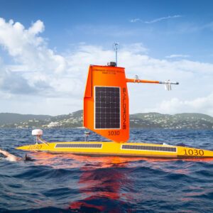
Long-running partnership with Saildrone aims to improve hurricane forecasting and rapid intensification models Saildrone announced plans to deploy 10 Saildrone Explorer unmanned surface vehicles (USVs) during the 2026 hurricane season in partnership with National Oceanic and Atmospheric Administration (NOAA). The mission will support hurricane forecasting and storm research … [Read more...] about NOAA Sends Autonomous Surface Vehicles Into Hurricanes to Study Rapid Intensification
NOAA
Woolpert and Saildrone Deploy Autonomous USV for NOAA Seafloor Mapping Near Mariana Islands

Woolpert and Saildrone have partnered to collect and process bathymetric survey data for NOAA's Ocean Exploration and Office of Coast Survey. The mission supports safe navigation and ocean mapping initiatives, including the National Strategy for Mapping, Exploring, and Characterizing the United States Exclusive Economic Zone and the Seabed 2030 initiative. The … [Read more...] about Woolpert and Saildrone Deploy Autonomous USV for NOAA Seafloor Mapping Near Mariana Islands
Meteodrones Provide New Data to National Weather Service
Switzerland-based meteorology data company Meteomatics has announced a partnership with NOAA's National Mesonet Program (NMP) to integrate operational weather drone data into National Weather Service forecasts—marking the first time drone-collected observations will feed directly into U.S. weather forecasting operations. Meteodrones Fill Critical Data Gaps The Meteodrones … [Read more...] about Meteodrones Provide New Data to National Weather Service
NOAA and GrandSky Partner to Enhance Weather Forecasting with Drones

Innovative 2-Year Research Agreement Utilizes Meteodrones to Improve Atmospheric Data Collection and Forecast Accuracy by DRONELIFE Staff Writer Ian J. McNab The National Oceanographic and Atmospheric Association’s (NOAA) National Weather Service recently announced a new 2-year research partnership with North Dakota-based GrandSky Airfield Operations to use drones and other … [Read more...] about NOAA and GrandSky Partner to Enhance Weather Forecasting with Drones
GPS-Denied Navigation: Black Swift Moves Drone Flight Forward with NOAA Contract
NOAA has awarded Black Swift Technologies (BST) a contract to develop GPS-denied navigation, enabling Beyond Visual Line of Sight (BVLOS) operations for drones in GNSS-denied environments. NOAA has almost 95,000 miles of domestic coastline to survey - and while drones are by far the best way to complete the mission, flying within visual line of sight (VLOS) makes the mission … [Read more...] about GPS-Denied Navigation: Black Swift Moves Drone Flight Forward with NOAA Contract


