• Skip to main content
  • Skip to secondary menu
  • Skip to primary sidebar
  • Skip to secondary sidebar
  • Skip to footer
  • DroneRacingLife
  • DroneFlyers
  • Newsletter
DroneLife

DRONELIFE

Stay up to date on all the latest Drone News

  • News
  • Products
  • Industries
    • Agriculture
    • Construction
    • Delivery
    • Dual Use
    • Inspection
    • Public Safety
    • Surveying
  • Enthusiasts
  • Regulations
  • Business
  • Video
  • Podcasts

Woolpert and Saildrone Deploy Autonomous USV for NOAA Seafloor Mapping Near Mariana Islands

February 26, 2026 by Ian McNabb Leave a Comment

Woolpert and Saildrone have partnered to collect and process bathymetric survey data for NOAA’s Ocean Exploration and Office of Coast Survey. The mission supports safe navigation and ocean mapping initiatives, including the National Strategy for Mapping, Exploring, and Characterizing the United States Exclusive Economic Zone and the Seabed 2030 initiative.

Image Provided By Saildrone


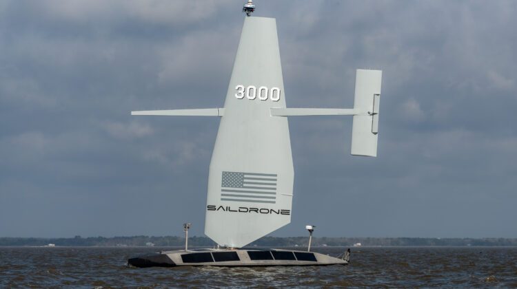
The Saildrone Surveyor

The centerpiece of the operation is the 20-meter Saildrone Surveyor uncrewed surface vehicle (USV). The Surveyor measures 20 m (65 ft) in hull length, with a 13 m (44 ft) wing height, a 3 m (11 ft) draft, and a cruise speed of 6 knots. Primary propulsion comes from the patented Saildrone Wing, with a 78 hp high-efficiency diesel engine providing auxiliary power. This dual-source architecture delivers up to 100 days of endurance between service stops and provides 2,000 W steady-state and 4,000 W peak payload power.​

For Saildrone Surveyor bathymetric mapping, the vehicle carries a Kongsberg EM 304 MkII multibeam sonar for deep water and a Kongsberg EM 2040 MkII for shallow-water operations. An Applanix POS MV OceanMaster handles positioning, while Teledyne ADCP units monitor ocean currents. Satellite communications run via Starlink and Iridium, enabling near-real-time data transmission.​

Mariana Islands Mission

This month, the Saildrone Surveyor began collecting high-resolution bathymetric data across a 13,000-square-nautical-mile area of the northwestern Pacific Ocean near the Mariana Islands. NOAA will use the data to enhance understanding of sensitive habitats, marine geohazards, seafloor composition, oceanographic conditions, and ecosystem management within the US exclusive economic zone. It will also expand taxonomic reference libraries for understudied marine organisms.

“The seafloor mapping and exploration data that the Surveyor collects around the Mariana Islands will close critical bathymetric gaps in the United States’ exclusive economic zone,” said Brian Connon, vice president of ocean mapping at Saildrone. “The Surveyor’s ability to remain at sea for months at a time, regardless of weather conditions or sea state, makes it an ideal platform to carry out this vital work. Saildrone is proud to be working with both Woolpert and NOAA in these crucial efforts to better understand our ocean, marine resources, and ecosystem.”

Real-Time Processing Pipeline

Saildrone transmits data to Woolpert in near-real time for processing and final delivery. Woolpert Maritime Market Director Dave Neff highlighted the integration between Saildrone’s mission portal and Woolpert’s automated survey production environment. “By integrating Saildrone’s mission portal with Woolpert’s automated survey production environment, we gain real-time visibility into acquisition progress and data quality—especially in deep-water regions that were once difficult and costly to access,” Neff said. “This collaboration shows how uncrewed systems and smart partnerships can expand what’s possible in ocean mapping.”

The contract is currently underway and expects to conclude in May 2026.

More information is available from the original press release.

Read More

  • DJI Seeks Court Review as FCC Covered List Expansion Reshapes U.S. Drone Market
  • Canada’s Defence Industry Unites: ACDC Launches to Advocate for Autonomous and Drone Capabilities
  • House Blocks ROTOR Act; Focus Shifts to ALERT Act and ADS-B Policy
Ian McNabb

Ian McNabb is a journalist focusing on drone technology and lifestyle content at Dronelife. He is based between Boston and NH and, when not writing, enjoys hiking and Boston area sports.

Filed Under: Conservation, Drone News, Drone News Feeds, Mapping, Mapping Technology, News, Research, seadrones, Weather Tagged With: autonomous ocean mapping, bathymetric mapping, commercial drone news, Commercial Drones, drone, drone news, Drone Technology, drones, hydrographic survey, Mariana Islands, marine science, maritime autonomy, NOAA, ocean drones, ocean mapping, Saildrone, Seabed 2030, seadrones, seafloor mapping, uncrewed surface vehicle, USV, Woolpert

Reader Interactions

Leave a Reply Cancel reply

Your email address will not be published. Required fields are marked *

Primary Sidebar

LATEST

Digital Force Technologies and Powerus Build Full-Stack Counter-UAS Kill-Chain

Digital Force Technologies (DFT) and Powerus have announced a strategic partnership to deliver a fully integrated counter-UAS kill-chain. The system…

Continue Reading Digital Force Technologies and Powerus Build Full-Stack Counter-UAS Kill-Chain

COUNTER Act and Secure Our Skies: New Mexico Congressman Pushes New Drone Bills

By Dronelife Features Editor Jim Magill As the widespread use of UAVs proliferates across the country, along with the inherent…

Continue Reading COUNTER Act and Secure Our Skies: New Mexico Congressman Pushes New Drone Bills

Pentagon Filing Opposes DJI Petition, Citing National Security Risks and Classified Information

Department of Defense submission to FCC reinforces concerns over foreign-made drone technology A newly filed memorandum from the U.S. Department…

Continue Reading Pentagon Filing Opposes DJI Petition, Citing National Security Risks and Classified Information

Africa’s Drone Manufacturing Push Signals a New Global Supply Chain

Nigeria-based Terra Industries scales production with backing from U.S. investors, pointing to a third path beyond the U.S. and China…

Continue Reading Africa’s Drone Manufacturing Push Signals a New Global Supply Chain

ePropelled Expands Hercules Starter Generator Line With Scalable Hybrid Power for Drones

ePropelled has announced a major 2026 expansion of its Hercules starter generator product line. The update targets hybrid drone propulsion…

Continue Reading ePropelled Expands Hercules Starter Generator Line With Scalable Hybrid Power for Drones

Inside the Coachella Valley’s Plan to Centralize Drone First Responder Operations

By Dronelife Features Editor Jim Magill The Palm Springs, California Police Department is taking its Drones as First Responders (DFR)…

Continue Reading Inside the Coachella Valley’s Plan to Centralize Drone First Responder Operations

Teledyne FLIR OEM Upgrades Prism SKR Software for Autonomous Target Recognition

New release combines mission execution and intelligent supervision in a single autonomy platform Teledyne FLIR OEM has announced an upgrade…

Continue Reading Teledyne FLIR OEM Upgrades Prism SKR Software for Autonomous Target Recognition

Drone Operations Software Company AirHub Closes €4.4M Series A

AirHub, a European drone operations software company based in The Hague, has closed a €4.4 million Series A funding round.…

Continue Reading Drone Operations Software Company AirHub Closes €4.4M Series A

Arrive AI Patents Shared Drone Delivery Endpoint With Tenth U.S. Patent

Arrive AI (NASDAQ: ARAI) has secured its tenth U.S. patent, strengthening its intellectual property portfolio for autonomous drone delivery infrastructure.…

Continue Reading Arrive AI Patents Shared Drone Delivery Endpoint With Tenth U.S. Patent

Korean eVTOL Developer Airbility Partners on UAV Public Safety in Thailand

South Korean eVTOL developer Airbility has signed a four-party Memorandum of Understanding to deploy UAV systems for public safety and…

Continue Reading Korean eVTOL Developer Airbility Partners on UAV Public Safety in Thailand

Secondary Sidebar

Footer

SPONSORED

Inspired Flight Gremsy IF800 VIO F1 drones geo week

What Will It Take to Strengthen U.S. Drone Manufacturing? A Conversation with Inspired Flight’s CEO

Global Mapper Mobile data collection

Collection Ground Control Points with Global Mapper Mobile

Military Drone Mapping Solutions

How SimActive’s Correlator3Dâ„¢ is Revolutionizing Military Mapping: An Exclusive Interview with CEO Philippe Simard

Photogrammetry Accuracy Standards

SimActive Photogrammetry Software: Enabling Users to Meet Accuracy Standards for Over 20 Years

NACT Engineering Parrot ANAFI tether indoor shot

Smart Tether for Parrot ANAFI USA from NACT Engineering

Blue Marble, features global mapper, features Blue Marble

Check Out These New Features in Global Mapper v25 from Blue Marble

About Us | Contact Us | Advertise With Us | Write for Us | Privacy Policy | Terms of Service

The Trusted Source for the Business of Drones.

This website uses cookies and third party services. By clicking OK, you are agreeing to our privacy policy. ACCEPT

Manage consent

Privacy Overview

This website uses cookies to improve your experience while you navigate through the website. Out of these, the cookies that are categorized as necessary are stored on your browser as they are essential for the working of basic functionalities of the website. We also use third-party cookies that help us analyze and understand how you use this website. These cookies will be stored in your browser only with your consent. You also have the option to opt-out of these cookies. But opting out of some of these cookies may affect your browsing experience.
Necessary
Always Enabled
Necessary cookies are absolutely essential for the website to function properly. These cookies ensure basic functionalities and security features of the website, anonymously.
CookieDurationDescription
cookielawinfo-checkbox-analytics11 monthsThis cookie is set by GDPR Cookie Consent plugin. The cookie is used to store the user consent for the cookies in the category "Analytics".
cookielawinfo-checkbox-functional11 monthsThe cookie is set by GDPR cookie consent to record the user consent for the cookies in the category "Functional".
cookielawinfo-checkbox-necessary11 monthsThis cookie is set by GDPR Cookie Consent plugin. The cookies is used to store the user consent for the cookies in the category "Necessary".
cookielawinfo-checkbox-others11 monthsThis cookie is set by GDPR Cookie Consent plugin. The cookie is used to store the user consent for the cookies in the category "Other.
cookielawinfo-checkbox-performance11 monthsThis cookie is set by GDPR Cookie Consent plugin. The cookie is used to store the user consent for the cookies in the category "Performance".
viewed_cookie_policy11 monthsThe cookie is set by the GDPR Cookie Consent plugin and is used to store whether or not user has consented to the use of cookies. It does not store any personal data.
Functional
Functional cookies help to perform certain functionalities like sharing the content of the website on social media platforms, collect feedbacks, and other third-party features.
Performance
Performance cookies are used to understand and analyze the key performance indexes of the website which helps in delivering a better user experience for the visitors.
Analytics
Analytical cookies are used to understand how visitors interact with the website. These cookies help provide information on metrics the number of visitors, bounce rate, traffic source, etc.
Advertisement
Advertisement cookies are used to provide visitors with relevant ads and marketing campaigns. These cookies track visitors across websites and collect information to provide customized ads.
Others
Other uncategorized cookies are those that are being analyzed and have not been classified into a category as yet.
SAVE & ACCEPT