Accuracy in Drone Mapping: What You Need to Know
Over the last few years, as drone technology has advanced, so too has the ability for drone maps to be highly accurate. But what exactly do we mean when we talk about accuracy in drone mapping? Is it always important for a map to be highly accurate? And what range of accuracy can you expect from your maps? We’ve put together a primer to help you better understand the basics of drone mapping accuracy.
Defining Accuracy for Drone Maps
When it comes to drone mapping, there are two ways to think about accuracy: relative accuracy and absolute accuracy.
- Relative (or local) accuracy: Relative accuracy is the degree to which a given point on a map is accurate relative to other points within that same map. In other words, if a distance between two points measures 10 inches in the real world, it also measures 10 inches on your map.
- Absolute (or global) accuracy: Absolute accuracy, on the other hand, is the degree to which a point on a map corresponds to a fixed coordinate system in the real world. If a map has a high level of global accuracy, the latitude and longitude of a point on that map will correspond fairly accurately with actual GPS coordinates.
What Accuracy Level Do I Need for My Project?
Your project goals will determine what level of accuracy you require. Some projects need a high level of global accuracy, while in other cases, relative accuracy will suffice. When referring to the use of ground control points, which greatly improve a map’s absolute accuracy, Hunter Cole of construction company Brasfield & Gorrie puts the decision this way:
“If we’re going to make a critical determination off of the data set, absolutely we’re going to use GCPs. If it’s more for a marketing effort or we’re making smaller relative volumetric measurements, we may not bother with GCPs on that site.”- Hunter Cole, Brasfield & Gorrie
Assessing each project — the desired outputs, where and how the final map will be used, what decisions will be made based off the information — will help you determine how important accuracy is in any given situation. While it’s tempting to think that greater accuracy is always better, the tactics and technology required to achieve extremely high levels of accuracy can add significant time and expense to your project and aren’t always necessary or worthwhile for your objectives.

Although projects should be evaluated on a case-by-case basis, we’ve listed the project types that are generally well suited to each level of accuracy.
Relative Accuracy: Management, Measurement and Marketing
Relative accuracy is usually sufficient for projects like taking small-scale measurements, visually inspecting progress on construction sites and monitoring fields for crop health. Essentially, any time you need to gather information from within a map itself, but do not necessarily need to place that map accurately in space. Because drone maps contain thousands of points, compared to the few hundred points obtained through traditional survey methods, maps with relative accuracy give a highly detailed overview of terrain that works well for these types of projects.
Projects for which relative accuracy is usually sufficient:
- Small-scale measurements — e.g., area of a field, length of a fence, width of a stockpile
- Management and oversight — e.g., keeping tabs on general progress of a construction site
- Crop scouting — e.g., assessing damage after a storm, monitoring crop health
- Marketing — e.g., creating a time-lapse or 3D model project to share with prospective clients
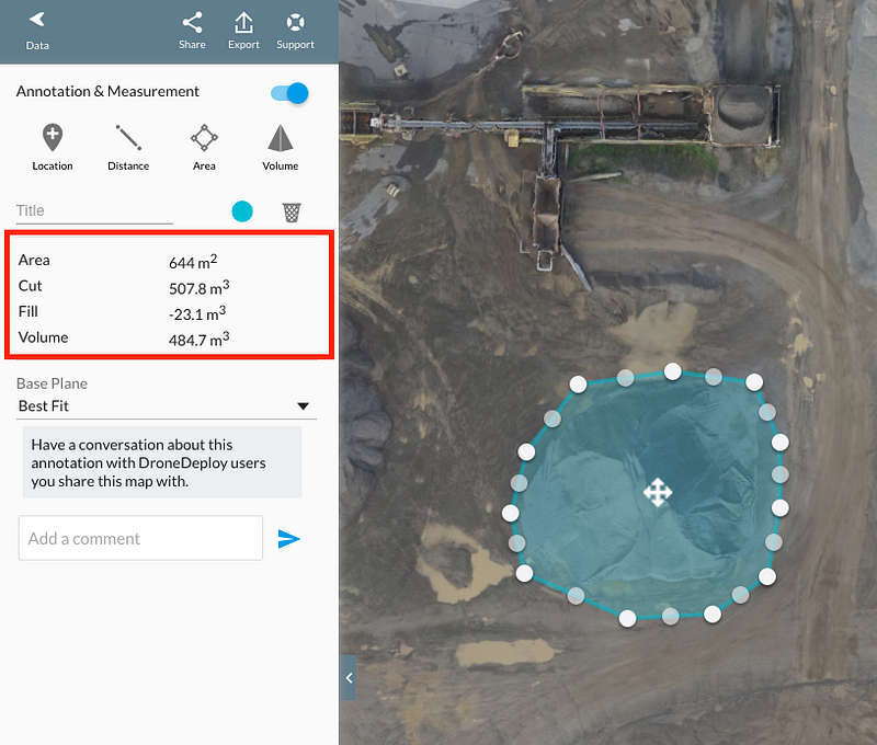
As an example, Kelsey Martin of Martin Remote Sensing recently compared volume calculations of a stockpile that he made with a drone map to those that were made of the same stockpile using traditional ground-based GPS measurements. He found that the drone-based volume calculation came within 0.6% accuracy of the GPS measurements. In this case, relative accuracy was more than sufficient for calculating the volume of the stockpile.
Absolute Accuracy: Surveys and Overlays
Absolute accuracy becomes important when you need a high degree of confidence that the latitudinal, longitudinal and elevation measurements are correct, such as when combining your map with other geo-referenced data sets.
Projects for which absolute accuracy is important:
- Land title surveys
- Design documents and records for construction projects
- Environmental records
- Overlays of geo-referenced site plans
Madison D of Landpoint, a surveying company in Louisiana, completed a topographic survey on land being developed for a new real estate subdivision. In this case, an extremely accurate topographical survey was necessary in order to ensure the land was developed to allow for proper drainage, and to document the topography in relation to the adjacent river floodplain. Because this information would be used to make decisions about flood damage prevention, and could also be called up on for flood insurance purposes, it was important that the survey had a high level of absolute accuracy.
A Note About “Survey-Grade” Accuracy
If you’ve been involved with drone mapping for a while, chances are you’ve heard the term “survey-grade accurate.” While this term is sometimes used loosely, it is important to understand that for a map to truly be considered a survey, it needs to be able to hold up in court because it is required by regulation or for legal arbitration. As such, certain standards must be followed to communicate how accurate the map is. These standards are laid out in the American Society of Photogrammetry and Remote Sensing (ASPRS) guidelines. A survey must also be stamped by a licensed surveyor. As-built surveys, flood prevention hydrology surveys and land-title surveys are just a few examples of situations in which survey-grade accuracy is necessary.
How to Check the Absolute Accuracy of Your Map
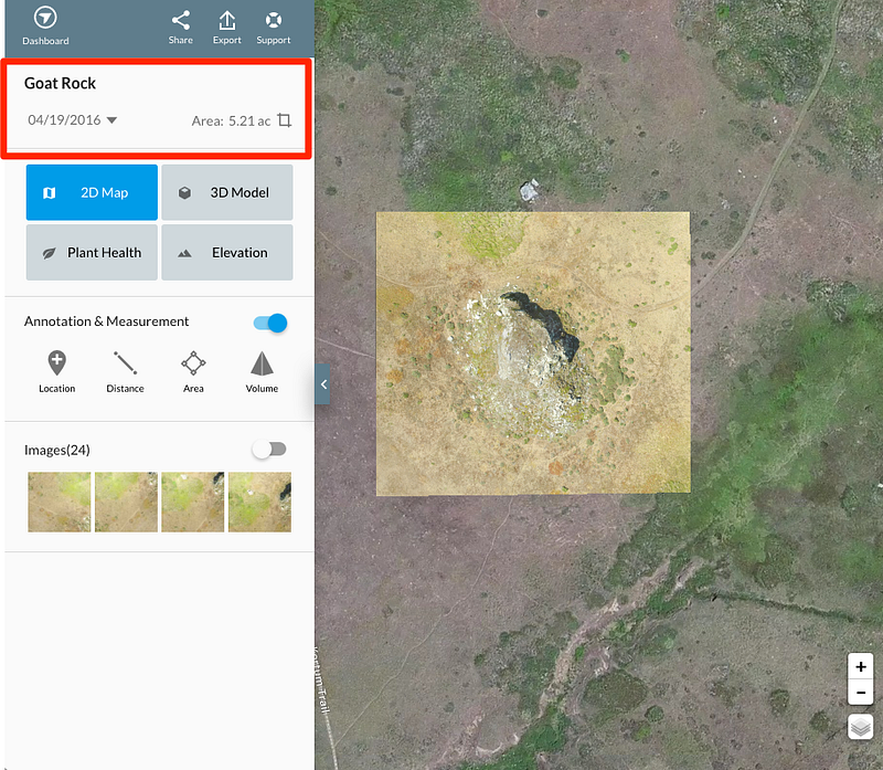
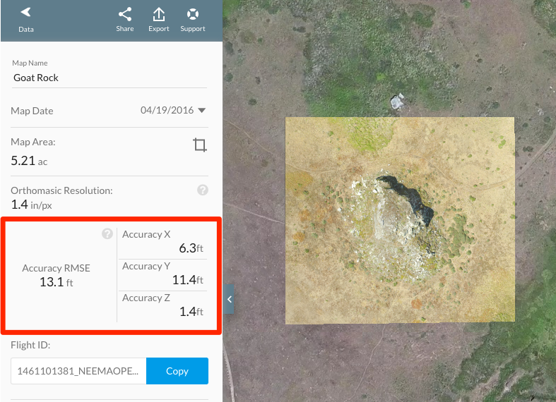
In your DroneDeploy dashboard, it is easy to check the absolute accuracy of your map. Just click the small down arrow at the top of the side panel next to your map to reveal a set of accuracy numbers.
When Map Engine processes imagery into a map, it uses both the camera GPS information on the photos as well as shared features that appear in multiple images to create a 3D reconstruction of the area of interest. The accuracy of a map is expressed as the average error between where the GPS said the camera was and where DroneDeploy calculates the camera needed to be in order to make the overlapping images stitch together into a map. The larger the error between the two, the lower the data accuracy.
You’ll see figures noting the accuracy of the X,Y, and Z accuracy, and also a figure noting the total Root Mean Squared Error (RMSE). The X,Y and Z values refer to the root mean square errors for all of the individual cameras in the X, Y or Z directions, and the total RMSE is the root mean square error across all three different directions.
What Accuracy Can You Expect?
There are a number of factors that affect accuracy, which we will explain at length in a post next week. But in general, given average conditions and a typical drone, you can expect approximately the following ranges of accuracy:
Relative accuracy: Is typically a multiple of your data’s average Ground Sampling Distance (GSD). The horizontal relative accuracy is 2x GSD (for example, if your GSD is 2 cm/pixel, the horizontal accuracy will be approximately 4 cm) and the vertical relative accuracy is typically 3x GSD.
GSD refers to the number of pixels per centimeter of your data. The higher the number of pixels per centimeter, the greater the relative accuracy of your map.
Absolute horizontal accuracy: approximately 1 meter (3ft)
If you draw a circle around you with a 1 meter radius, and give someone your GPS location, you can expect them to turn up somewhere within this circle.
Absolute vertical accuracy: approximately 3 meters (9ft)
As a rule of thumb, the absolute vertical accuracy of a map will be around 3 times worse than its absolute horizontal accuracy
This is just an example of the accuracy you might see out-of-the-box with a standard drone. However, accuracy is highly dependent upon the drone you use and the quality of the data you collect, and it is possible to use drones to make maps to within centimeter accuracy. Stay tuned for the next post on accuracy to learn best practices to improve the accuracy of your maps.
Where to Learn More
Read more about Martin Remote Sensing learned when they compared the accuracy of drone surveys to GPS ground surveys. For more great information about some of the tools mentioned here, take a look at our support documentation:
Frank Schroth is editor in chief of DroneLife, the authoritative source for news and analysis on the drone industry: it’s people, products, trends, and events.
Email Frank
TWITTER:@fschroth


Cost of Drones are not expenisve as compare to other flying object it is very helpful if you are doing surveys , mapping. We are a leading UAV Service provider thats we know beneficial parts of that. thanks for informative blog.