• Skip to main content
  • Skip to secondary menu
  • Skip to primary sidebar
  • Skip to secondary sidebar
  • Skip to footer
  • DroneRacingLife
  • DroneFlyers
  • Newsletter
DroneLife

DRONELIFE

Stay up to date on all the latest Drone News

  • News
  • Products
  • Industries
    • Agriculture
    • Construction
    • Delivery
    • Dual Use
    • Inspection
    • Public Safety
    • Surveying
  • Enthusiasts
  • Regulations
  • Business
  • Video
  • Podcasts

Mapping Asia’s Largest Copper Ore Mine, Using Drones

May 16, 2018 by Malek Murison 4 Comments

A Czech drone services company, UpVision, has been using UAVs to map the largest copper ore mine in Asia. The mapping mission spanned more than 10km² near the city of Erdenet, Mongolia.

In support of Czech geologists investigating the site, the UpVision team deployed a MAVinci Sirius, produced by the German manufacturer acquired by Intel back in 2016. The fixed-wing drone is known for its durability and ability to withstand challenging terrain – Ideal for flying at altitude above the Mongolian wilderness.

mongolia mapping a mine upvision

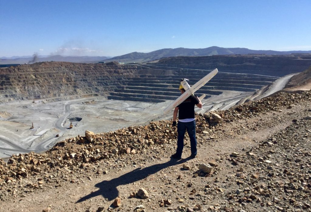
Dealing with challenging terrain

The irony is that the mapping team’s greatest challenge was the very terrain they were attempting to accurately capture: uneven elevations made the job more complex than it would normally be. The UpVision team was able to build two tangible results from following the MAVinci flights. First was a detailed digital surface model (DSM) and the second was an orthophoto in different image resolutions.

Because different elevations in the terrain created issues with image overlapping and resolution, the entire mine was mapped in high density with a total of eight flights at different heights and different image resolutions.

“Mapping took place in challenging terrain with large elevations and at an altitude of about 1,400m. In the location near the town of Erdenet there is a strong wind and a lot of dust during the day. In terms of the weather, there can be strong temperature fluctuations in early May, when it is not unusual for snow to fall in the morning and for temperatures to be above 20°C the next day.”

“That is why it was necessary to adapt the flying in the early morning and in the evening hours, and to divide it into several missions,” said UpVision co-owner Jakub Karas.

Read more: Drones in Mining: A Special Kind of Drone for Inaccessible Spaces

Mapping: With a little help from a DJI Mavic Air

upvision mapping a mine in mongolia dji mavic air

A DJI Mavic Air was also used as part of the mission. The tiny drone captured the aerial imagery needed to map the mine’s vertical walls, allowing the team to put together geological measurement drawings.

Malek Murison
Malek Murison

Malek Murison is a freelance writer and editor with a passion for tech trends and innovation. He handles product reviews, major releases and keeps an eye on the enthusiast market for DroneLife.
Email Malek
Twitter:@malekmurison

Subscribe to DroneLife here.

Filed Under: Business and Finance, Drone News Feeds, Enthusiasts, Featured, Mining and Aggregates, Video Tagged With: copper mine, dji mavic, mapping, MAVinci, mongolia, sirius

Reader Interactions

Trackbacks

  1. Mapping Asia’s Largest Copper Ore Mine, Using Drones | Drone Magazine says:
    May 20, 2018 at 9:29 pm

    […] Source […]

    Reply
  2. Mapping Asia’s Largest Copper Ore Mine, Using Drones - King Drones Review | The Drones Kingdom says:
    May 16, 2018 at 10:01 pm

    […] post Mapping Asia’s Largest Copper Ore Mine, Using Drones appeared first on […]

    Reply
  3. Mapping Asia’s Largest Copper Ore Mine, Using Drones | MUSIC 4 DRONES says:
    May 16, 2018 at 5:35 pm

    […] post Mapping Asia’s Largest Copper Ore Mine, Using Drones appeared first on […]

    Reply
  4. Mapping Asia’s Largest Copper Ore Mine, Using Drones - Drone Services Company | Aerial Photo and Video | Miami Florida says:
    May 16, 2018 at 4:36 pm

    […] post Mapping Asia’s Largest Copper Ore Mine, Using Drones appeared first on […]

    Reply

Leave a Reply Cancel reply

Your email address will not be published. Required fields are marked *

Primary Sidebar

LATEST

Who Builds the Sky? How Regional Partnerships Are Creating the Infrastructure for Advanced Air Mobility

On this episode of the Drone Radio Show, Lavera Alexander of the Monterey Bay Economic Partnership discusses why the future…

Continue Reading Who Builds the Sky? How Regional Partnerships Are Creating the Infrastructure for Advanced Air Mobility

FAA Moves from Planning to Building for Advanced Air Mobility

New research facility signals shift from policy development to operational readiness The Federal Aviation Administration is taking another step toward…

Continue Reading FAA Moves from Planning to Building for Advanced Air Mobility

How Skyways Quietly Built a Global Heavy-Lift Drone Business

Texas-based company expands offshore cargo operations while preparing for the next phase of U.S. BVLOS regulations By DRONELIFE Features Editor…

Continue Reading How Skyways Quietly Built a Global Heavy-Lift Drone Business

National Resilience Strategy Connects the Dots Behind U.S. Drone Policy

New White House strategy frames commercial drones as part of a broader effort to strengthen U.S. manufacturing, infrastructure, and supply…

Continue Reading National Resilience Strategy Connects the Dots Behind U.S. Drone Policy

Beyond the Drone: Percepto’s New Platform Brings AI to Infrastructure Inspections

Percepto launches next-gen inspection software By DRONELIFE Features Editor Jim Magill For energy companies, producing actionable data is almost as…

Continue Reading Beyond the Drone: Percepto’s New Platform Brings AI to Infrastructure Inspections

Danish Investigation Finds No Proof Drones Caused Copenhagen Airport Shutdown

Nine-month investigation underscores the need for better airspace awareness, not just more speculation News and Commentary.  A nine-month investigation into…

Continue Reading Danish Investigation Finds No Proof Drones Caused Copenhagen Airport Shutdown

Flytrex and Wing Report Zero Airspace Conflicts for Multi-Operator Drone Delivery

Flytrex says automated UTM coordination with Wing has deconflicted 100% of operations in Dallas–Fort Worth shared airspace, with zero conflicts.…

Continue Reading Flytrex and Wing Report Zero Airspace Conflicts for Multi-Operator Drone Delivery

BRINC Partnership Gives Public Safety Agencies an “Immediate Upgrade” in Incident Intelligence

BRINC and Nova Partner to Add Advanced Mapping and Thermal Intelligence for Public Safet Public safety drone manufacturer BRINC has…

Continue Reading BRINC Partnership Gives Public Safety Agencies an “Immediate Upgrade” in Incident Intelligence

Prodrone Debuts All-Japanese Industrial Drone

This article published in collaboration with JUIDA, the Japan UAS Industrial Development Association.     Aichi-based Prodrone introduces the PD4B-MS prototype,…

Continue Reading Prodrone Debuts All-Japanese Industrial Drone

Uruguayan Government Announces New Drone Dispatch Program

The Montevideo deployment, run in partnership with Uruguayan technology firm Timerix, ties gunshot-detection alerts to automated drone dispatch and live…

Continue Reading Uruguayan Government Announces New Drone Dispatch Program

Secondary Sidebar

Footer

SPONSORED

Inspired Flight Gremsy IF800 VIO F1 drones geo week

What Will It Take to Strengthen U.S. Drone Manufacturing? A Conversation with Inspired Flight’s CEO

Global Mapper Mobile data collection

Collection Ground Control Points with Global Mapper Mobile

Military Drone Mapping Solutions

How SimActive’s Correlator3D™ is Revolutionizing Military Mapping: An Exclusive Interview with CEO Philippe Simard

Photogrammetry Accuracy Standards

SimActive Photogrammetry Software: Enabling Users to Meet Accuracy Standards for Over 20 Years

NACT Engineering Parrot ANAFI tether indoor shot

Smart Tether for Parrot ANAFI USA from NACT Engineering

Blue Marble, features global mapper, features Blue Marble

Check Out These New Features in Global Mapper v25 from Blue Marble

About Us | Contact Us | Advertise With Us | Write for Us | Privacy Policy | Terms of Service

The Trusted Source for the Business of Drones.

This website uses cookies and third party services. By clicking OK, you are agreeing to our privacy policy. ACCEPT

Manage consent

Privacy Overview

This website uses cookies to improve your experience while you navigate through the website. Out of these, the cookies that are categorized as necessary are stored on your browser as they are essential for the working of basic functionalities of the website. We also use third-party cookies that help us analyze and understand how you use this website. These cookies will be stored in your browser only with your consent. You also have the option to opt-out of these cookies. But opting out of some of these cookies may affect your browsing experience.
Necessary
Always Enabled
Necessary cookies are absolutely essential for the website to function properly. These cookies ensure basic functionalities and security features of the website, anonymously.
CookieDurationDescription
cookielawinfo-checkbox-analytics11 monthsThis cookie is set by GDPR Cookie Consent plugin. The cookie is used to store the user consent for the cookies in the category "Analytics".
cookielawinfo-checkbox-functional11 monthsThe cookie is set by GDPR cookie consent to record the user consent for the cookies in the category "Functional".
cookielawinfo-checkbox-necessary11 monthsThis cookie is set by GDPR Cookie Consent plugin. The cookies is used to store the user consent for the cookies in the category "Necessary".
cookielawinfo-checkbox-others11 monthsThis cookie is set by GDPR Cookie Consent plugin. The cookie is used to store the user consent for the cookies in the category "Other.
cookielawinfo-checkbox-performance11 monthsThis cookie is set by GDPR Cookie Consent plugin. The cookie is used to store the user consent for the cookies in the category "Performance".
viewed_cookie_policy11 monthsThe cookie is set by the GDPR Cookie Consent plugin and is used to store whether or not user has consented to the use of cookies. It does not store any personal data.
Functional
Functional cookies help to perform certain functionalities like sharing the content of the website on social media platforms, collect feedbacks, and other third-party features.
Performance
Performance cookies are used to understand and analyze the key performance indexes of the website which helps in delivering a better user experience for the visitors.
Analytics
Analytical cookies are used to understand how visitors interact with the website. These cookies help provide information on metrics the number of visitors, bounce rate, traffic source, etc.
Advertisement
Advertisement cookies are used to provide visitors with relevant ads and marketing campaigns. These cookies track visitors across websites and collect information to provide customized ads.
Others
Other uncategorized cookies are those that are being analyzed and have not been classified into a category as yet.
SAVE & ACCEPT