
• Skip to main content
  • Skip to secondary menu
  • Skip to primary sidebar
  • Skip to secondary sidebar
  • Skip to footer
  • DroneRacingLife
  • DroneFlyers
  • Newsletter
DroneLife

DRONELIFE

Stay up to date on all the latest Drone News

  • News
  • Products
  • Industries
    • Agriculture
    • Construction
    • Delivery
    • Dual Use
    • Inspection
    • Public Safety
    • Surveying
  • Enthusiasts
  • Regulations
  • Business
  • Video
  • Podcasts

Drone Analytics: When to Use Ground Control Points

June 5, 2017 by Frank Schroth 1 Comment

 Guest post DroneDeploy

How To Decide If Your Drone Mapping Project Needs GCPs

Ground control points (GCPs) can be an invaluable tool for aerial mapping. When used correctly, they help ensure a high degree of global accuracy, which is important for most surveying and construction projects. But the fact is, the majority of drone maps don’t require GCPs. Because of this, it’s important to understand when to use ground control points and when to skip them. But how do you decide if your drone mapping project needs GCPs?

In an earlier post, we wrote about using ground control points to improve the accuracy of aerial maps. Today, we take a look at what types of aerial maps benefit from ground control points and why using them may — or may not — be important for your next project.
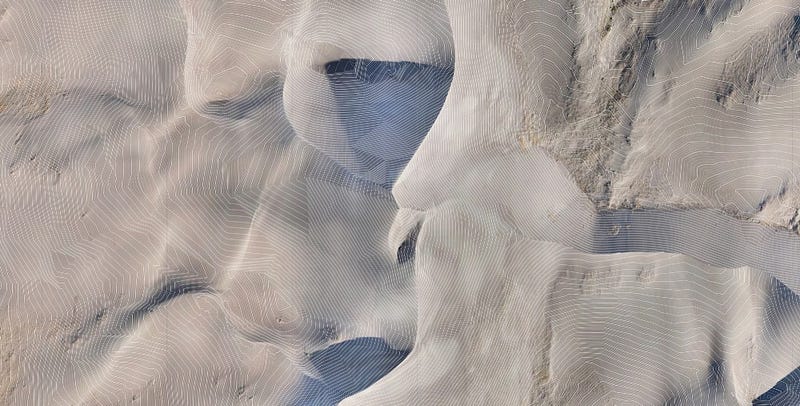
Wohnrade Civil Engineers used ground control points during an aerial topographic survey of the Great Sand Dunes. Their drone-generated map was the basis for this digital terrain model with 1-foot contours.

When to Use Ground Control Points

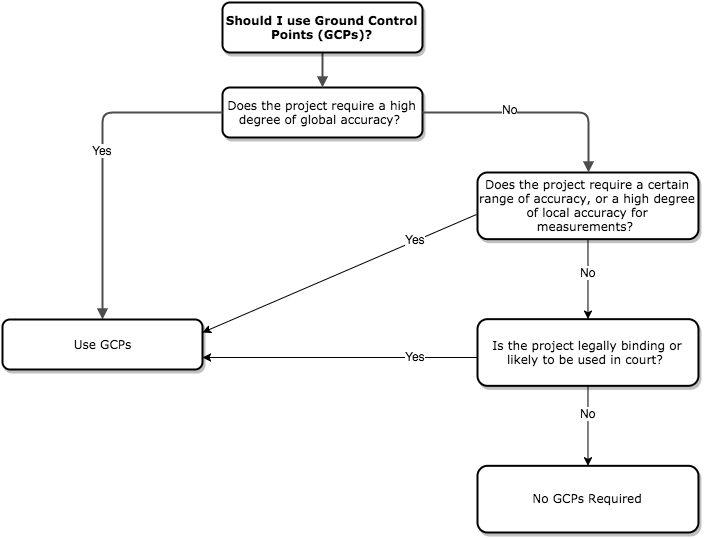
In general, there are two reasons to use GCPs: if you need a high degree of global accuracy, or if you are contracted to provide measurements within a certain range of accuracy.

If your project requires a high degree of global accuracy, then you should use ground control points. Land surveys and DOT road inspections are two examples of projects that require true global accuracy.

Ground control points were important to Bon Air Drone’s Shelly Engle when she used aerial mapping to generate a contour map of a quarry in Virginia. Strategically placed GCPs helped Shelly ensure the map had a high degree of global accuracy. This was important when she orthorectified the final contour map.

As Bon Air co-owner Kyle Falwell puts it, this level of accuracy sets their company apart from the competition. “Our top priority is the quality control side of it,” says Kyle. “There are a lot of people out there doing aerial surveys, but we want to hang our hat on accuracy.”

Not sure what global accuracy is? Read our post about the basics of accuracy in drone mapping.
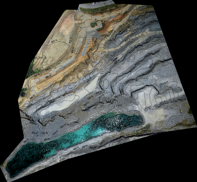
Bon Air Drone used GCPs to improve global accuracy for their map of a quarry. This level of accuracy was important when they generated a contour map of the quarry.

Likewise, GCPs are important if you use an aerial map to take volumetric or linear measurements and you are contracted to provide those measurements within a certain range of accuracy. This is the case for many civil engineering and construction projects, where 1/10 foot accuracy is often required.

Construction company Brasfield & Gorrie considers the purpose of each map before deciding whether to use GCPs. “If we’re going to make a critical determination off of the data set, absolutely we’re going to use GCPs,” says VDC coordinator Hunter Cole. “If it’s more for a marketing effort or we’re making smaller relative volumetric measurements, we may not bother with GCPs on that site.”

If you’re unsure about using GCPs, check out our short diagram below. It will quickly help you decide if they are necessary for the next project you’re working on.
GCPs When a Surveyor’s Signature is Required

If your aerial mapping project requires a surveyor’s signature, you should use ground control points. Surveying companies generally use GCPs because a high level of global accuracy is important to their work.

Common surveying projects where ground control points are useful include:

Property boundary surveys: Accuracy is essential here, because property boundary surveys are usually the last word in property line disputes. An aerial map can be used to compare plat data and determine if a property line has moved.

Insurance assessments: A good example of this is a FEMA survey for flood insurance, which uses accurate elevation data to determine a property’s flood risk.

Subdivision and new construction surveys: Local and federal regulations often require surveys in order to document the presence of utilities like gas and power lines, or water mains.

General liability: If structural damage occurs to a building, it is likely a lawsuit will be filed against the contractor who built it. Having survey records that show the structure was built up to code helps protect the contractor from being held liable.

Ground control points are often used to prove the accuracy of measurements on construction sites.

Using Ground Control Points to Prove the Accuracy of Measurements

In general, when you use a map to take volumetric or linear measurements within a map — say, to measure stockpile volumes or the length of a fence — ground control points aren’t necessary. In most cases, as long as the resolution of a map is good, the margin of error for measurements is going to be the same with or without GCPs. This is because there is a positive correlation between high-resolution images and stitching accuracy. Following a few best practices can help ensure you produce high-resolution maps.

That being said, engineering and construction projects still use ground control points, even for maps that don’t require global accuracy and don’t need a surveyor’s signature. In many cases, contracts require that measurements taken on a project fall within a certain range of accuracy. Ground control points may not do much to increase the accuracy of measurements, but they are a good way to prove that these measurements are accurate.

Best Flight Practices When Using GCPs

If you decide ground control points are the right choice for your aerial mapping project, the next step is choosing the best flight parameters and following best practices to ensure the accuracy of your map. Ultimately, your flight parameters will depend on your mapping subject, but here are some general guidelines to keep in mind when using GCPs.

Flight Altitude
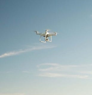
  • 250–350 feet for most maps. This range will give you a good amount of resolution, but won’t bog down the stitching process with too many images.
  • 400 feet for large projects. For especially large maps, such as in the forestry industry, a higher altitude is necessary. Less resolution is needed for this type of map, and a higher altitude lets you cover a large area quickly while collecting enough data relative to the tallest feature in the map.

Overlap

75/75 overlap recommended; don’t exceed 85/85. Higher overlap increases accuracy, but too much overlap slows down processing speeds unnecessarily.

Ground-truthing with vertical checkpoints

Ground-truthing your data is very important to ensure the accuracy can be replicated using multiple methods.

Test shots

Taking a few test shots helps you verify that you are seeing the correct output. It also gives you another number that you can stand by when presenting the accuracy of your map.

EPSG Codes

Before processing your map in DroneDeploy, you must enter the EPSG code that relates to your GPS measurements. Choose your EPSG code by modifying the settings of your GPS measurement device.

In most cases, we recommend using WGS84 (EPSG: 4326). One exception is when you need to compare your aerial map to existing plat data from a previous land survey. In that case, be sure to collect data in the same reference system that was used when the original land survey was taken.

Using GCPs: Where to Learn More

No matter what subject you are mapping, or what your aerial mapping project requires, understanding when — and when not — to use GCPs is an important lesson for any drone operator. Likewise, knowing how to correctly position, measure and record ground control points can make all the difference when your project requires that you use them.

  • Our guide to using ground control points is a good first step for understanding how to use them.
  • To learn more about global accuracy, including tips on how to improve it, read Part 1 and Part 2 of our accuracy in drone mapping series.
  • For more information about accuracy standards in surveying, consult the ASPRS Positional Accuracy Standards.

Get Started with DroneDeploy

Want to learn how DroneDeploy can help your business? Visit www.dronedeploy.com to start your free trial or request a consultation with one of our team members. The DroneDeploy mobile application is available for free download for both iOS and Android devices.

Frank Schroth
Frank Schroth

Frank Schroth is editor in chief of DroneLife, the authoritative source for news and analysis on the drone industry: it’s people, products, trends, and events.
Email Frank
TWITTER:@fschroth


Filed Under: Applications, Construction, Industries, Mining and Aggregates, Surveying Tagged With: DroneDeploy, ground control points, mapping

Reader Interactions

Trackbacks

  1. Drone Analytics: When to Use Ground Control Points | CRPAA - Certified Remote Pilots Association of America says:
    June 5, 2017 at 3:16 pm

    […] post Drone Analytics: When to Use Ground Control Points appeared first on […]

    Reply

Leave a Reply Cancel reply

Your email address will not be published. Required fields are marked *

Primary Sidebar

LATEST

Cat-Inspired Claws Help Ice Dart Drone Land on Steep Ice

Université de Sherbrooke researchers demonstrate a new approach to landing multirotors on steep, irregular ice surfaces Cats may seem an…

Continue Reading Cat-Inspired Claws Help Ice Dart Drone Land on Steep Ice

Motorola Solutions Completes $1.5 Billion Acquisition of D-Fend Solutions

Counter-drone technology joins Motorola Solutions’ public safety portfolio as demand for airspace protection grows Motorola Solutions has completed its $1.5…

Continue Reading Motorola Solutions Completes $1.5 Billion Acquisition of D-Fend Solutions

Ondas Opens UAS Training and Operations Hub at Ohio’s NAAMCE

New Springfield facility will support long-endurance UAS training, testing and flight operations as Ondas expands its U.S. defense business Ondas…

Continue Reading Ondas Opens UAS Training and Operations Hub at Ohio’s NAAMCE

The White House Wants Drone Dominance. How Much of the Supply Chain Must Be American?

Recent executive orders, FCC action and a White House industry meeting point to growing scrutiny of what goes into U.S.-made…

Continue Reading The White House Wants Drone Dominance. How Much of the Supply Chain Must Be American?

FCC Proposal Could Bring Drone Software and Supply Chains Under Greater Scrutiny

Active FCC rulemaking considers hardware and software disclosures that could affect agricultural and commercial drone manufacturers A new FCC rulemaking…

Continue Reading FCC Proposal Could Bring Drone Software and Supply Chains Under Greater Scrutiny

United Utilities Uses Thermal Drones to Find Hidden Moorland Fire Hotspots

Thermal imaging drones help crews locate underground heat pockets that could reignite after major fires in northwest England. United Utilities…

Continue Reading United Utilities Uses Thermal Drones to Find Hidden Moorland Fire Hotspots

Inside the Counter-UAS Response to Drone Flights Over Spokane Wildfires

FBI and local officials describe how a multi-agency task force detected dozens of unauthorized drones, located pilots and worked to…

Continue Reading Inside the Counter-UAS Response to Drone Flights Over Spokane Wildfires

Saildrone Announces European Expansion With Copenhagen HQ and Three Build Contracts

The maritime autonomy company adds three European build partners and opens Northern Europe operations at the historic Quintus Bastion in…

Continue Reading Saildrone Announces European Expansion With Copenhagen HQ and Three Build Contracts

HOVERAir Launches VERSA 2-in-1 Gimbal and Camera Drone

The 2-in-1 device from ZeroZero Robotics records 4K 60fps video and converts from a pocket gimbal camera into a self-flying…

Continue Reading HOVERAir Launches VERSA 2-in-1 Gimbal and Camera Drone

uAvionix FlightLine Surveillance Data Feeds Airwise Nexus at Skyway Range in Tulsa

The partnership feeds low-altitude cooperative aircraft data from uAvionix’s FlightStation network into the Airwise Nexus platform for Skyway Range BVLOS…

Continue Reading uAvionix FlightLine Surveillance Data Feeds Airwise Nexus at Skyway Range in Tulsa

Secondary Sidebar

Footer

SPONSORED

What Is the Best Commercial Cleaning Drone in 2026? Specs, Prices, and a Head-to-Head Comparison

Inspired Flight Gremsy IF800 VIO F1 drones geo week

What Will It Take to Strengthen U.S. Drone Manufacturing? A Conversation with Inspired Flight’s CEO

Global Mapper Mobile data collection

Collection Ground Control Points with Global Mapper Mobile

Military Drone Mapping Solutions

How SimActive’s Correlator3D™ is Revolutionizing Military Mapping: An Exclusive Interview with CEO Philippe Simard

Photogrammetry Accuracy Standards

SimActive Photogrammetry Software: Enabling Users to Meet Accuracy Standards for Over 20 Years

NACT Engineering Parrot ANAFI tether indoor shot

Smart Tether for Parrot ANAFI USA from NACT Engineering

About Us | Contact Us | Advertise With Us | Write for Us | Privacy Policy | Terms of Service

The Trusted Source for the Business of Drones.

This website uses cookies and third party services. By clicking OK, you are agreeing to our privacy policy. ACCEPT

Manage consent

Privacy Overview

This website uses cookies to improve your experience while you navigate through the website. Out of these, the cookies that are categorized as necessary are stored on your browser as they are essential for the working of basic functionalities of the website. We also use third-party cookies that help us analyze and understand how you use this website. These cookies will be stored in your browser only with your consent. You also have the option to opt-out of these cookies. But opting out of some of these cookies may affect your browsing experience.
Necessary
Always Enabled
Necessary cookies are absolutely essential for the website to function properly. These cookies ensure basic functionalities and security features of the website, anonymously.
CookieDurationDescription
cookielawinfo-checkbox-analytics11 monthsThis cookie is set by GDPR Cookie Consent plugin. The cookie is used to store the user consent for the cookies in the category "Analytics".
cookielawinfo-checkbox-functional11 monthsThe cookie is set by GDPR cookie consent to record the user consent for the cookies in the category "Functional".
cookielawinfo-checkbox-necessary11 monthsThis cookie is set by GDPR Cookie Consent plugin. The cookies is used to store the user consent for the cookies in the category "Necessary".
cookielawinfo-checkbox-others11 monthsThis cookie is set by GDPR Cookie Consent plugin. The cookie is used to store the user consent for the cookies in the category "Other.
cookielawinfo-checkbox-performance11 monthsThis cookie is set by GDPR Cookie Consent plugin. The cookie is used to store the user consent for the cookies in the category "Performance".
viewed_cookie_policy11 monthsThe cookie is set by the GDPR Cookie Consent plugin and is used to store whether or not user has consented to the use of cookies. It does not store any personal data.
Functional
Functional cookies help to perform certain functionalities like sharing the content of the website on social media platforms, collect feedbacks, and other third-party features.
Performance
Performance cookies are used to understand and analyze the key performance indexes of the website which helps in delivering a better user experience for the visitors.
Analytics
Analytical cookies are used to understand how visitors interact with the website. These cookies help provide information on metrics the number of visitors, bounce rate, traffic source, etc.
Advertisement
Advertisement cookies are used to provide visitors with relevant ads and marketing campaigns. These cookies track visitors across websites and collect information to provide customized ads.
Others
Other uncategorized cookies are those that are being analyzed and have not been classified into a category as yet.
SAVE & ACCEPT



