This article published in collaboration with JUIDA, the Japan UAS Industrial Development Association. Blue Innovation Co., Ltd. deployed drones for nighttime aerial imaging during a forest fire on Mount Ogi in Yamanashi Prefecture, Japan. The company responded to a dispatch request from the Japan Ground Self-Defense Force (JGSDF) Eastern Army, relayed … [Read more...] about Blue Innovation Deploys Drones for Nighttime Wildfire Imaging in Japan
Surveying
Windracers ULTRA to Map Greenland’s Petermann Glacier
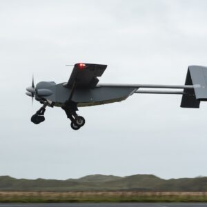
By Dronelife Features Editor Jim Magill An international team of researchers plans to deploy Windracers’ dual-use heavy-lift drone technology to study the interactions of ice and ocean water in the frigid Arctic region of northwestern Greenland. The study, which is expected to get under way this summer, will be a critical part of the so-called GIANT (Greenland Ice sheet … [Read more...] about Windracers ULTRA to Map Greenland’s Petermann Glacier
Spexi Orthomosaic Drone Imagery Now Available on SkyWatch Platform

SkyWatch has announced the addition of Spexi orthomosaic drone imagery to its platform, expanding access to standardized aerial data for mapping and analysis. The integration allows users to source ultra-high-resolution drone imagery directly through SkyWatch’s EXPLORE and HUB applications. With the launch, SkyWatch customers can access Spexi’s stitched, orthorectified imagery … [Read more...] about Spexi Orthomosaic Drone Imagery Now Available on SkyWatch Platform
Phase One Unveils iXM-FS130 Camera for Sub-Centimeter Aerial Mapping
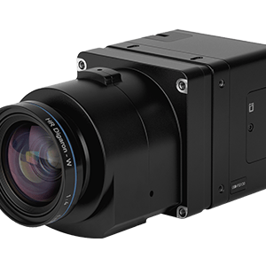
Phase One has announced the iXM-FS130, a next-generation aerial mapping camera designed to capture sub-centimeter ground sample distance imagery from fixed-wing aircraft at speeds exceeding 120 knots. The camera introduces Phase One's patented Fusion Shutter technology to the commercial aerial mapping market. This enables operators to maintain image quality while increasing … [Read more...] about Phase One Unveils iXM-FS130 Camera for Sub-Centimeter Aerial Mapping
Wingcopter 198 Drones to Support Aerial Surveying in Japan

Wingcopter’s long-range Wingcopter 198 drone will be deployed for aerial surveying in Japan under a new collaboration between ITOCHU Corporation, PASCO Corporation, and YellowScan Japan Co., Ltd. The partners have signed an MOU to apply the platform to disaster management, terrain mapping, and post-event restoration tasks. The Wingcopter 198 combines vertical takeoff and … [Read more...] about Wingcopter 198 Drones to Support Aerial Surveying in Japan


