
• Skip to main content
  • Skip to secondary menu
  • Skip to primary sidebar
  • Skip to secondary sidebar
  • Skip to footer
  • DroneRacingLife
  • DroneFlyers
  • Newsletter
DroneLife

DRONELIFE

Stay up to date on all the latest Drone News

  • News
  • Products
  • Industries
    • Agriculture
    • Construction
    • Delivery
    • Dual Use
    • Inspection
    • Public Safety
    • Surveying
  • Enthusiasts
  • Regulations
  • Business
  • Video
  • Podcasts

Experts Tested 4 Different Drone Mapping Solutions for Crime Scene Investigation. Here’s What Happened.

September 29, 2021 by Miriam McNabb 6 Comments

At Commercial UAV Expo in Las Vegas, more than 300 drone industry professionals watched as experts tested four different drone mapping solutions for crime scene investigation at night.

Guest post by Douglas Spotted Eagle, Founder and Director of Educational Programming at Sundance Media Group.  DRONELIFE neither accepts nor makes payment for guest posts.

Commercial UAV Expo brought UAS professionals, developers, manufacturers, first responders, and related industries under one roof for the first time in nearly two years. Due to the pandemic, the show was less attended than previous years, yet provided robust live demonstrations, night flight, daytime seminars, panels, and case studies for the relatively large audience. There was a strong buzz amongst the crowd about being at an in-person event, and experiencing face to face communication for the first time in many months.


In addition to the “Beyond the Cage” Live Drone Demo Day that launched Commercial UAV 2021, produced by Sundance Media Group, Wednesday night provided attendees with a glimpse of the Crime Scene Investigator tools function in the dark hours. Sundance Media Group developed this methodology several years ago at the request of a law enforcement agency and has been presenting this methodology at academies, colleges, universities, and tradeshows since 2017, with a variety of aircraft including DJI Mavic, Phantom 4, Yuneec H520, Skydio, and Autel EVO series (versions 1 and 2). All successfully output data, excepting Skydio, which struggles with brightly lit events in surrounding darkness.

Presented by FoxFury, Sundance Media Group, Autel, and Pix4D, this event also invited SkyeBrowse to participate in the demonstration, showing the effectiveness and speed of their application.

Testing Drone Mapping Solutions for Crime Scene Investigation: Setting the Scene

With a model covered in moulage, mock slit throat, and blood trail on the ground, the demonstration began with the multi-vendor team led by Brady Reisch, Bryan Worthen of Kuker-Ranken, Todd Henderson and Patrick Harris of SMG,  and David Martel.  The team  placed four FoxFury T56 lighting systems at specific, measured points in the scene, supplemented by FoxFury NOW  lanterns and Rugo lighting to fill in holes and eliminate shadows.

Douglas Spotted Eagle of SMG and KukerRanken emcee’d the event through the two flights.

Douglas Spotted Eagle addresses the crowd of 300 persons

SkyeBrowse had the first flight, with its one-button capture. Brady Reisch set up the mission, with input from the SkyeBrowse developer instructing the exposure levels of the camera for the SkyeBrowse video mission. Once the mission was completed, the photos were uploaded to the SkyeBrowse website, where results were found approximately 30 minutes following the flight.

Brady Reisch of KukerRanken sets up the Skybrowse mission with Bobby Ouyang of Skybrowse

The Autel EVO II Pro was programmed on-site for an automated Skybrowse mission and the demonstration began. The area is highly congested with palm trees and buildings enclosing the small rotunda in front of the Mirage Hotel Convention Center.

Brady Reisch flew the second EVO II  mission manually, in much the same configuration as though the aircraft had flown a double-grid mission, supplemented by high-altitude orbit, coupled with manually captured orbit and select placements. Because of the crowd, time was a consideration. In an actual homicide scene, more low-placed images would have been captured.


Brady Reisch monitors time as Pix4DReact rapid-renders the scene (60 seconds)

The mission photos were uploaded to Pix4dReact on-scene and rendered while the audience observed, requiring approximately 60 seconds to output an ortho-rectified, 2D image, complete with evidence markers/tags, and PDF supplemental report output. Also loaded were the photo images into Pix4D and Leica Infinity software packages, to be rendered for 3D viewing once the show floor opened on Thursday. Pix4DReact is a two-dimensional, rapid-mapping solution, so there is no 3D view.

The four screen captures tell the rest of the story, and readers can determine for themselves what each software is capable of providing.  One point of interest is that there were many claims of “guaranteed 1cm of precision regardless of flight area,” which has yet to be verified. The Kuker-Ranken team will be re-flying a mission with two separate GPS systems (Leica and Emlid) to verify the claims of precision.

Precision is Repeatable

Precision is repeatable. Accuracy is the degree of closeness to true value. Precision is the degree to which an instrument or process will repeat the same value. In other words, accuracy is the degree of veracity while precision is the degree of reproducibility. With a base station, NTRIP, Spydernet, PPK, or RTK workflow, precision is always the goal, well-beyond accuracy. This is a relatively new discussion in the use of unmanned aircraft, and although the topic seems simple enough, complexity holds challenges not easily dismissed by inexperience or lacking education and practice.  We are fortunate to have a partner in Kuker-Ranken, providing precision tools to the survey, forensic, civil engineering, and AEC industries since 1928. The KR team includes PLS’, EIT, and other accredited precision professionals, rarely found in the UAS industry.

Precision is critical for surveyors, civil engineers, forensic analysts and investigators, construction sites, mapping, agriculture, and other verticals in the UAS industry, and this sort of scene is no exception. Being able to properly place a map or model into a coordinate is necessary for many professional pilots in the UAV field, and while this mission is not precise to coordinate, it is precise within itself, or in other words, measurements will be accurate in the image, while being imprecise to the overall location.

We’ll dive more deeply into precision in a future article. For purposes of this exercise, we’re more interested in accuracy of content in the scene, and all four outputs were similar in accuracy within the scene itself. In other words, distances, volumes, and angles may be measured point to point. Pix4DReact is not as accurate as the other three tools, as it’s not intended to be a deeply accurate application given speed of output.

Output Results of Drone Mapping Solutions

Output #1: SkyeBrowse (processing time, approximately 35 minutes)
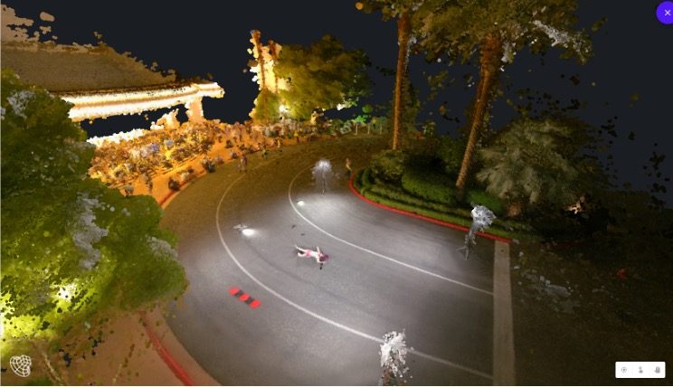
 

Output #2: Pix4Dreact (processing time, approximately 1 minute)
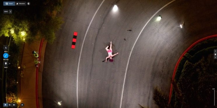
drone mapping solution Pix4Dreact


Output #3: Pix4Dmapper (processing time, approximately 2.5 hours)
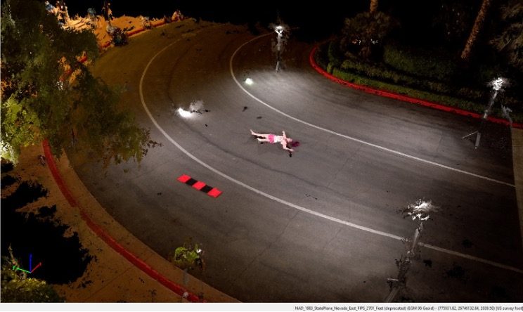
drone mapping solutions Pix4Dmapper

Output #4: Leica Infinity (processing time, approximately 2 hours, 50 minutes)
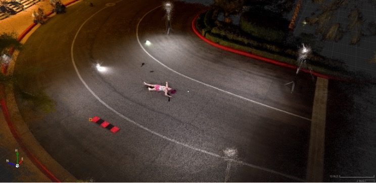
drone mapping solutions Leica Infinity

Agencies who would like access to this data are invited to contact Brady Reisch, VDC Specialist at Kuker-Ranken.

Douglas Spotted Eagle is the Founder and Director of Educational Programming at Sundance Media Group.  SMG serves as a consultant within the sUAS industry, offering training and speaking engagements on sUAS topics: UAV cinematography, commercial and infrastructural sUAS applications, sUAS risk management, night UAV flight, aerial security systems, and 107 training.   

 

Miriam McNabb

Miriam McNabb is the Editor-in-Chief of DRONELIFE and CEO of JobForDrones, a professional drone services marketplace, and a fascinated observer of the emerging drone industry and the regulatory environment for drones. Miriam has penned over 3,000 articles focused on the commercial drone space and is an international speaker and recognized figure in the industry.  Miriam has a degree from the University of Chicago and over 20 years of experience in high tech sales and marketing for new technologies.
For drone industry consulting or writing, Email Miriam.

TWITTER:@spaldingbarker

Subscribe to DroneLife here.

Filed Under: DL Exclusive, Drone News Feeds, Featured, News Tagged With: autel evo, Autel EVO II Pro, Pix4D, Pix4D Mapper, Pix4Dreact, SkyeBrowse

Reader Interactions

Trackbacks

  1. विशेषज्ञों ने अपराध स्थल की जांच के लिए 4 अलग-अलग ड्रोन मैपिंग समाधानों का परीक्षण किया। यहाँ क्य says:
    October 4, 2021 at 5:54 am

    […] Source link […]

    Reply
  2. Experts Test 4 Different Drone Mapping Solutions – Dronestagram Blog says:
    October 2, 2021 at 3:21 pm

    […] More… […]

    Reply
  3. Experts Tested 4 Different Drone Mapping Solutions for Crime Scene Investigation. Here’s What Happened. – Top Drones & reviews says:
    September 29, 2021 at 11:05 pm

    […] post Experts Tested 4 Different Drone Mapping Solutions for Crime Scene Investigation. Here’s What Happ… appeared first on […]

    Reply
  4. Experts Test 4 Different Drone Mapping Solutions – Game Up News says:
    September 29, 2021 at 3:11 pm

    […] Source link […]

    Reply
  5. Experts Tested 4 Different Drone Mapping Solutions for Crime Scene Investigation. Here’s What Happened. – DronePilots.News says:
    September 29, 2021 at 11:25 am

    […] post Experts Tested 4 Different Drone Mapping Solutions for Crime Scene Investigation. Here’s What Happ… appeared first on […]

    Reply
  6. Experts Tested 4 Different Drone Mapping Solutions for Crime Scene Investigation. Here’s What Happened. | Drone Films Limited says:
    September 29, 2021 at 11:16 am

    […] post Experts Tested 4 Different Drone Mapping Solutions for Crime Scene Investigation. Here’s What … appeared first on […]

    Reply

Leave a Reply Cancel reply

Your email address will not be published. Required fields are marked *

Primary Sidebar

LATEST

U.S. Army Thermal Imaging Program Targets Next-Generation Drone Sensors

Teledyne FLIR OEM joins DUTCH initiative focused on performance, SWaP-C, and high-volume domestic production Teledyne FLIR OEM has been selected…

Continue Reading U.S. Army Thermal Imaging Program Targets Next-Generation Drone Sensors

Airbound Raises $37 Million Series A and Plans 10,000 Daily Drone Flights Across Andhra Pradesh

The Bengaluru aerospace startup, led by Greenoaks with DoorDash participation, targets a payload-to-aircraft ratio three times better than industry norms.…

Continue Reading Airbound Raises $37 Million Series A and Plans 10,000 Daily Drone Flights Across Andhra Pradesh

SkyDrive to Evaluate eVTOL Medical Logistics Routes in Mumbai, Delhi With Air India and Suzuki

The Japanese eVTOL developer identifies radioisotope transport, organ transport and airport parts logistics as priority use cases under the July…

Continue Reading SkyDrive to Evaluate eVTOL Medical Logistics Routes in Mumbai, Delhi With Air India and Suzuki

Quantum-Systems Opens Huntsville, Alabama Outpost

The U.S. subsidiary of the Quantum Systems Group opens a 3,200-square-foot engineering and R&D office in Huntsville’s Cummings Research Park…

Continue Reading Quantum-Systems Opens Huntsville, Alabama Outpost

Archer, AEG Plan Downtown Los Angeles Vertiport at L.A. LIVE

Proposed site would become the first announced downtown node in Archer’s planned Los Angeles air taxi network ahead of the…

Continue Reading Archer, AEG Plan Downtown Los Angeles Vertiport at L.A. LIVE

FCC Grants Conditional Approval for Ascento UAS

Ascento Guard Dori USA v1 joins a growing list of UAS exempted from the FCC Covered List through the federal…

Continue Reading FCC Grants Conditional Approval for Ascento UAS

New Survey Shows Just How Dependent Construction Is on Chinese Drones

ABC finds nearly all drone-using respondents rely primarily on DJI, highlighting the challenge of shifting to alternative platforms by DRONELIFE…

Continue Reading New Survey Shows Just How Dependent Construction Is on Chinese Drones

Cat-Inspired Claws Help Ice Dart Drone Land on Steep Ice

Université de Sherbrooke researchers demonstrate a new approach to landing multirotors on steep, irregular ice surfaces Cats may seem an…

Continue Reading Cat-Inspired Claws Help Ice Dart Drone Land on Steep Ice

Motorola Solutions Completes $1.5 Billion Acquisition of D-Fend Solutions

Counter-drone technology joins Motorola Solutions’ public safety portfolio as demand for airspace protection grows Motorola Solutions has completed its $1.5…

Continue Reading Motorola Solutions Completes $1.5 Billion Acquisition of D-Fend Solutions

Ondas Opens UAS Training and Operations Hub at Ohio’s NAAMCE

New Springfield facility will support long-endurance UAS training, testing and flight operations as Ondas expands its U.S. defense business Ondas…

Continue Reading Ondas Opens UAS Training and Operations Hub at Ohio’s NAAMCE

Secondary Sidebar

Footer

SPONSORED

What Is the Best Commercial Cleaning Drone in 2026? Specs, Prices, and a Head-to-Head Comparison

Inspired Flight Gremsy IF800 VIO F1 drones geo week

What Will It Take to Strengthen U.S. Drone Manufacturing? A Conversation with Inspired Flight’s CEO

Global Mapper Mobile data collection

Collection Ground Control Points with Global Mapper Mobile

Military Drone Mapping Solutions

How SimActive’s Correlator3D™ is Revolutionizing Military Mapping: An Exclusive Interview with CEO Philippe Simard

Photogrammetry Accuracy Standards

SimActive Photogrammetry Software: Enabling Users to Meet Accuracy Standards for Over 20 Years

NACT Engineering Parrot ANAFI tether indoor shot

Smart Tether for Parrot ANAFI USA from NACT Engineering

About Us | Contact Us | Advertise With Us | Write for Us | Privacy Policy | Terms of Service

The Trusted Source for the Business of Drones.

This website uses cookies and third party services. By clicking OK, you are agreeing to our privacy policy. ACCEPT

Manage consent

Privacy Overview

This website uses cookies to improve your experience while you navigate through the website. Out of these, the cookies that are categorized as necessary are stored on your browser as they are essential for the working of basic functionalities of the website. We also use third-party cookies that help us analyze and understand how you use this website. These cookies will be stored in your browser only with your consent. You also have the option to opt-out of these cookies. But opting out of some of these cookies may affect your browsing experience.
Necessary
Always Enabled
Necessary cookies are absolutely essential for the website to function properly. These cookies ensure basic functionalities and security features of the website, anonymously.
CookieDurationDescription
cookielawinfo-checkbox-analytics11 monthsThis cookie is set by GDPR Cookie Consent plugin. The cookie is used to store the user consent for the cookies in the category "Analytics".
cookielawinfo-checkbox-functional11 monthsThe cookie is set by GDPR cookie consent to record the user consent for the cookies in the category "Functional".
cookielawinfo-checkbox-necessary11 monthsThis cookie is set by GDPR Cookie Consent plugin. The cookies is used to store the user consent for the cookies in the category "Necessary".
cookielawinfo-checkbox-others11 monthsThis cookie is set by GDPR Cookie Consent plugin. The cookie is used to store the user consent for the cookies in the category "Other.
cookielawinfo-checkbox-performance11 monthsThis cookie is set by GDPR Cookie Consent plugin. The cookie is used to store the user consent for the cookies in the category "Performance".
viewed_cookie_policy11 monthsThe cookie is set by the GDPR Cookie Consent plugin and is used to store whether or not user has consented to the use of cookies. It does not store any personal data.
Functional
Functional cookies help to perform certain functionalities like sharing the content of the website on social media platforms, collect feedbacks, and other third-party features.
Performance
Performance cookies are used to understand and analyze the key performance indexes of the website which helps in delivering a better user experience for the visitors.
Analytics
Analytical cookies are used to understand how visitors interact with the website. These cookies help provide information on metrics the number of visitors, bounce rate, traffic source, etc.
Advertisement
Advertisement cookies are used to provide visitors with relevant ads and marketing campaigns. These cookies track visitors across websites and collect information to provide customized ads.
Others
Other uncategorized cookies are those that are being analyzed and have not been classified into a category as yet.
SAVE & ACCEPT




