• Skip to main content
  • Skip to secondary menu
  • Skip to primary sidebar
  • Skip to secondary sidebar
  • Skip to footer
  • DroneRacingLife
  • DroneFlyers
  • Newsletter
DroneLife

DRONELIFE

Stay up to date on all the latest Drone News

  • News
  • Products
  • Industries
    • Agriculture
    • Construction
    • Delivery
    • Dual Use
    • Inspection
    • Public Safety
    • Surveying
  • Enthusiasts
  • Regulations
  • Business
  • Video
  • Podcasts

The Newest Advance in 3D Modeling: Videogrammetry

March 13, 2020 by Miriam McNabb 10 Comments

The rise of videogrammetry is enabling 3D modeling for everyone: making the process easier and lowering barriers to adoption.

The following is a guest post by Bobby Ouyang, CEO of SkyeBrowse.  SkyeBrowse is an innovative software that enables 3D modeling through videogrammetry.  DRONELIFE neither accepts nor offers payments for guest posts.

The concept of aerial 3D modeling has been around for centuries, dating back to Leonardo da Vinci and beyond. It has been used for surveying battlefields, building cities, astronomical exploration, and everything in between. Certainly, the world has made huge technological strides in drone technology, how 3D models are produced, and how they can be used. So, what’s next?

More recently, photogrammetry (a term originally coined in 1867) has been used to create 3D models through various software that process images captured from drones. This approach became a game-changer, as it took the old practice of manual photography and automated it with data acquisition and the increasing computing power of modern times. In short, a supercomputer would process hundreds or even thousands of pictures and merge the available data to produce a 3D model.

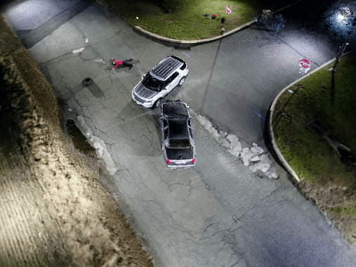
While photogrammetry-based software expanded the use of 3D modeling throughout many industries, it is complex and painstaking, and therefore its use has been relatively limited. This method of 3D modeling is time-consuming – both in gathering the data and in processing it. Capturing hundreds of individual photos can take hours and requires extensive training in the software. The flight is time-consuming and prone to increased risk as the drone has to slow down to take hundreds or thousands of individual photos. The pilot may also need to manually make adjustments dealing with percent overlap, ground sample distance, and photo resolution. This means that if a road accident is being captured, the scene may not be cleared for hours until proper 3D modeling photos are taken. Further, still photographs provide limited data and must be processed one by one. This can take days.

There is, however, a new alternative. Born from a series of research projects at Rutgers University, videogrammetry 3D modeling has become available to everyone in the form of software which allows anyone to make 3D models using their smartphones in just a couple of minutes.

Videogrammetry is the process of creating 3D models using videos instead of pictures. The advantages are numerous: to begin with, videos provide much more data than photos. The video frames, which are naturally shot in sequence, provide much more usable data than still photographs taken individually. From a recording perspective, the entire process is much faster because the drone flies at maximum speed to record video, saving time in capturing the scene and making the most of the drone’s battery life.

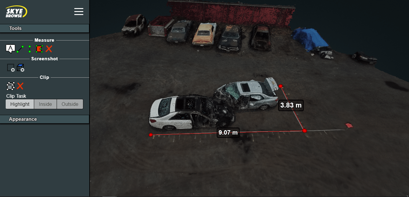
Additionally, the processing of the 3D model only takes a few minutes, and the results actually appear more clearly than photogrammetry-based models. Video-based 3D models do not display melting edges: the mixing of the edges of two objects, such as the base of a building and the ground it stands on, which is commonly seen in photogrammetry-based models. Thanks to the higher amount of data available in videos, this problem is easily avoided in videogrammetry.

Videogrammetry is a relatively new technology that is changing the landscape of the drone industry, just like photogrammetry did years ago. This means that the evidence in a car crash can now be captured in just a couple of minutes so the scene can be cleared off. It means that it takes less time, effort, and risk for roof inspectors to do their jobs by just flying their drone above the site, getting a model, and moving on. It means that a construction site can be captured within minutes without halting any activity on the site. Reduced traffic jams, decreased time spent by police officers gathering evidence, and increased productivity in commercial operations are just several of the immediate benefits of videogrammetry. These low adoption barriers will help the technology grow rapidly across many more industries.

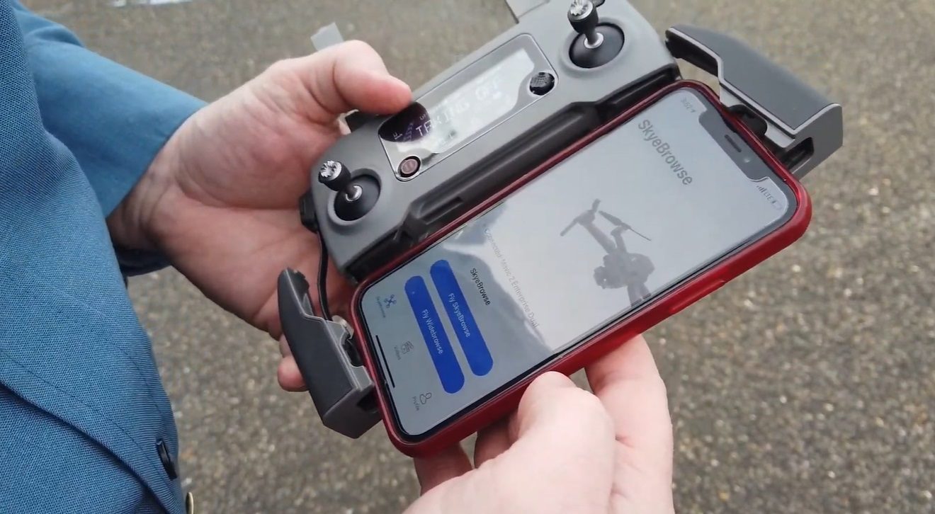
The speed, convenience, and simplicity of videogrammetry also mean that the technology is more affordable compared to photogrammetry, making 3D modeling available for all. Today, anybody can make 3D models in just a few minutes with their smartphones; it no longer requires extensive training, time, or resources to process it. Anybody who wishes to harness the true power of 3D modeling can now do it in just a few minutes with videogrammetry software like SkyeBrowse.

Bobby Ouyang, CEO, SkyeBrowse
Bobby is an international speaker, published author, and inventor. He has done software development and research on the Air-Traffic Incident Management System (Air-TIMS) funded by U.S. Department of Transportation back in 2016. This research led to the invention of SkyeBrowse’s autonomous drone flight, video-based 3D modeling, and tap-fly simplicity. Bobby co-authored the patent proposal for SkyeBrowse’s accident site reconstruction platform. He also trains law enforcement in various training workshops on best practices of flying drones. With his work on SkyeBrowse, Bobby has introduced the 2 tap simplicity of making a 3D model throughout the world.


Miriam McNabb

Miriam McNabb is the Editor-in-Chief of DRONELIFE and CEO of JobForDrones, a professional drone services marketplace, and a fascinated observer of the emerging drone industry and the regulatory environment for drones. Miriam has penned over 3,000 articles focused on the commercial drone space and is an international speaker and recognized figure in the industry.  Miriam has a degree from the University of Chicago and over 20 years of experience in high tech sales and marketing for new technologies.
For drone industry consulting or writing, Email Miriam.

TWITTER:@spaldingbarker

Subscribe to DroneLife here.

Filed Under: Drone News Feeds, Featured, News Tagged With: 3D modeling, Bobby Oeyang, drones and 3D modeling, photogrammetry, SkyeBrowse, videogrammetry

Reader Interactions

Trackbacks

  1. Videogrammetry for Thermal Mapping: Game Changing Technology for First Responders | taktik(z) GDI (Government Defense Infrastructure) says:
    June 6, 2021 at 9:00 pm

    […] early 2020, SkyeBrowse introduced 3D mapping through videogrammetry, the process of creating 3D models using one video, instead of hundreds of pictures. This became a […]

    Reply
  2. Videogrammetry for Thermal Mapping – DRONELIFE – My CMS says:
    June 6, 2021 at 8:39 pm

    […] early 2020, SkyeBrowse launched 3D mapping via videogrammetry, the method of making 3D fashions utilizing one video, as an alternative of tons of of images. This […]

    Reply
  3. Videogrammetry for Thermal Mapping - DRONELIFE - MyWealth -OptimismArcher says:
    June 6, 2021 at 7:28 pm

    […] early 2020, SkyeBrowse introduced 3D mapping through videogrammetry, the process of creating 3D models using one video, instead of hundreds of pictures. This became a […]

    Reply
  4. Videogrammetry for Thermal Mapping: Game Changing Technology for First Responders | Drone Films Limited says:
    June 6, 2021 at 5:18 pm

    […] early 2020, SkyeBrowse introduced 3D mapping through videogrammetry, the process of creating 3D models using one video, instead of hundreds of pictures. This became a […]

    Reply
  5. The Newest Advance in 3D Modeling: Videogrammetry – DroneLife – 3Dxpert says:
    March 13, 2020 at 2:38 pm

    […] source website […]

    Reply
  6. The Newest Advance in 3D Modeling: Videogrammetry | Drone Magazine says:
    March 13, 2020 at 12:56 pm

    […] Source […]

    Reply
  7. The Newest Advance in 3D Modeling: Videogrammetry ⋆ says:
    March 13, 2020 at 11:15 am

    […] The complete article is here […]

    Reply
  8. The Newest Advance in 3D Modeling: Videogrammetry – Best Drone Company says:
    March 13, 2020 at 11:11 am

    […] Source link […]

    Reply
  9. The Latest Advance in 3D Modeling: Videogrammetry - Drone Stuff Pro says:
    March 13, 2020 at 10:46 am

    […] Supply hyperlink […]

    Reply
  10. The Newest Advance in 3D Modeling: Videogrammetry | Gadgets says:
    March 13, 2020 at 10:12 am

    […] Source link […]

    Reply

Leave a Reply Cancel reply

Your email address will not be published. Required fields are marked *

Primary Sidebar

LATEST

NPSA Launches 2026 Counter-UAS Equipment Evaluations for UK Manufacturers

The National Protective Security Authority (NPSA) has opened expressions of interest for manufacturers and suppliers to participate in its independent…

Continue Reading NPSA Launches 2026 Counter-UAS Equipment Evaluations for UK Manufacturers

ISight Drone Services Achieves Statewide BVLOS Authorization for Vantis System in North Dakota

ISight Drone Services has received FAA approval to conduct beyond-visual-line-of-sight (BVLOS) operations across all four operational volumes of Vantis, North…

Continue Reading ISight Drone Services Achieves Statewide BVLOS Authorization for Vantis System in North Dakota

Unifly Completes FAA-Led Detect-and-Avoid Safety Standards Project

Terra Drone’s subsidiary Unifly has completed validation of “Well Clear Requirements” for drone Detect-and-Avoid (DAA) systems under the FAA’s ASSURE…

Continue Reading Unifly Completes FAA-Led Detect-and-Avoid Safety Standards Project

Meteodrones Provide New Data to National Weather Service

Switzerland-based meteorology data company Meteomatics has announced a partnership with NOAA’s National Mesonet Program (NMP) to integrate operational weather drone…

Continue Reading Meteodrones Provide New Data to National Weather Service

AURA Network Systems Conducts BVLOS Communications Tests

In collaboration with the Northern Plains UAS Test Site (NPUASTS) and the Federal Aviation Administration (FAA), AURA Network Systems has…

Continue Reading AURA Network Systems Conducts BVLOS Communications Tests

JIATF Awards First Replicator 2 Contract for C-UAS System

The Joint Interagency Task Force 401 (JIATF 401) has awarded its first contract under the Replicator 2 initiative, procuring two…

Continue Reading JIATF Awards First Replicator 2 Contract for C-UAS System

FAA Adds Two New UAS Test Sites to Advance Drone Integration

The U.S. Department of Transportation and the Federal Aviation Administration have announced two new UAS Test Sites in partnership with…

Continue Reading FAA Adds Two New UAS Test Sites to Advance Drone Integration

Kansas, Missouri Funding Counter-UAS at World Cup Events

By Dronelife Features Editor Jim Magill (Editor’s note: This is the second in a series of stories on efforts to…

Continue Reading Kansas, Missouri Funding Counter-UAS at World Cup Events

Electric UAS Demonstrates Relay-Extended Connectivity and Tactical Cross-Country Flights

Kraus Hamdani Aerospace (KHA) has completed a series of cross-country electric unmanned operations at Pendleton UAS Range (PUR) using its…

Continue Reading Electric UAS Demonstrates Relay-Extended Connectivity and Tactical Cross-Country Flights

Hirth Engines, ePropelled Partner For Hybrid UAV Power Systems

Hirth Engines and ePropelled announced a strategic collaboration to develop hybrid propulsion solutions targeting the UAV, aerospace, and defence markets.…

Continue Reading Hirth Engines, ePropelled Partner For Hybrid UAV Power Systems

Secondary Sidebar

Footer

SPONSORED

Inspired Flight Gremsy IF800 VIO F1 drones geo week

What Will It Take to Strengthen U.S. Drone Manufacturing? A Conversation with Inspired Flight’s CEO

Global Mapper Mobile data collection

Collection Ground Control Points with Global Mapper Mobile

Military Drone Mapping Solutions

How SimActive’s Correlator3D™ is Revolutionizing Military Mapping: An Exclusive Interview with CEO Philippe Simard

Photogrammetry Accuracy Standards

SimActive Photogrammetry Software: Enabling Users to Meet Accuracy Standards for Over 20 Years

NACT Engineering Parrot ANAFI tether indoor shot

Smart Tether for Parrot ANAFI USA from NACT Engineering

Blue Marble, features global mapper, features Blue Marble

Check Out These New Features in Global Mapper v25 from Blue Marble

About Us | Contact Us | Advertise With Us | Write for Us | Privacy Policy | Terms of Service

The Trusted Source for the Business of Drones.

This website uses cookies and third party services. By clicking OK, you are agreeing to our privacy policy. ACCEPT

Manage consent

Privacy Overview

This website uses cookies to improve your experience while you navigate through the website. Out of these, the cookies that are categorized as necessary are stored on your browser as they are essential for the working of basic functionalities of the website. We also use third-party cookies that help us analyze and understand how you use this website. These cookies will be stored in your browser only with your consent. You also have the option to opt-out of these cookies. But opting out of some of these cookies may affect your browsing experience.
Necessary
Always Enabled
Necessary cookies are absolutely essential for the website to function properly. These cookies ensure basic functionalities and security features of the website, anonymously.
CookieDurationDescription
cookielawinfo-checkbox-analytics11 monthsThis cookie is set by GDPR Cookie Consent plugin. The cookie is used to store the user consent for the cookies in the category "Analytics".
cookielawinfo-checkbox-functional11 monthsThe cookie is set by GDPR cookie consent to record the user consent for the cookies in the category "Functional".
cookielawinfo-checkbox-necessary11 monthsThis cookie is set by GDPR Cookie Consent plugin. The cookies is used to store the user consent for the cookies in the category "Necessary".
cookielawinfo-checkbox-others11 monthsThis cookie is set by GDPR Cookie Consent plugin. The cookie is used to store the user consent for the cookies in the category "Other.
cookielawinfo-checkbox-performance11 monthsThis cookie is set by GDPR Cookie Consent plugin. The cookie is used to store the user consent for the cookies in the category "Performance".
viewed_cookie_policy11 monthsThe cookie is set by the GDPR Cookie Consent plugin and is used to store whether or not user has consented to the use of cookies. It does not store any personal data.
Functional
Functional cookies help to perform certain functionalities like sharing the content of the website on social media platforms, collect feedbacks, and other third-party features.
Performance
Performance cookies are used to understand and analyze the key performance indexes of the website which helps in delivering a better user experience for the visitors.
Analytics
Analytical cookies are used to understand how visitors interact with the website. These cookies help provide information on metrics the number of visitors, bounce rate, traffic source, etc.
Advertisement
Advertisement cookies are used to provide visitors with relevant ads and marketing campaigns. These cookies track visitors across websites and collect information to provide customized ads.
Others
Other uncategorized cookies are those that are being analyzed and have not been classified into a category as yet.
SAVE & ACCEPT