
Carbonix says it is the first company in Australia to receive SAIL III certification for a drone, clearing a path to scalable long-range BVLOS operations. Sydney-based autonomous aviation company Carbonix has become the first company in Australia to achieve Safety Assurance Integrity Level (SAIL) III drone certification, according to the company. Carbonix says the milestone, … [Read more...] about Carbonix and CASA Certify First SAIL III Drone in Australia
photogrammetry
Landair Surveys Uses SimActive Correlator3D for Planned Burns Mapping in Australia
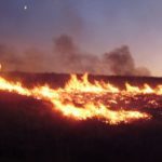
The Australian geospatial firm is using Correlator3D to generate orthomosaics from aerial imagery captured for wildfire prevention and land management projects. SimActive has announced that Landair Surveys is using its Correlator3D software to produce orthomosaics for planned burns mapping projects in Australia. The Montreal-based developer said the workflow is intended to … [Read more...] about Landair Surveys Uses SimActive Correlator3D for Planned Burns Mapping in Australia
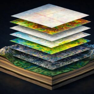
Gaussian Splatting Meets Photogrammetry: SimActive Integrates New Capability in Correlator3D

From Industry Buzz to Practical Workflow Gaussian splatting has quickly become one of the most talked-about developments in 3D reconstruction. Known for its ability to create highly realistic, smooth-rendered scenes, the technique has sparked a central question across the geospatial industry: can it move beyond visualization and support real-world mapping workflows? With the … [Read more...] about Gaussian Splatting Meets Photogrammetry: SimActive Integrates New Capability in Correlator3D
Blue Marble Geographics and Avenza Systems Combine to Create Unified Geospatial Platform
Merger connects office-based analysis with field operations for end-to-end spatial workflows Blue Marble Geographics and Avenza Systems, Inc. have announced a combined organization that will operate under the Blue Marble Geographics name. The move brings together complementary geospatial technologies designed to connect office-based spatial analysis with field data collection … [Read more...] about Blue Marble Geographics and Avenza Systems Combine to Create Unified Geospatial Platform
Can You Get Survey-Grade Accuracy Without Ground Control Points?
New Study Explores When Drone Mapping Can Reduce Ground Setup A new white paper from Swiss drone manufacturer Wingtra takes on a long-standing question in drone surveying: is it possible to achieve survey-grade accuracy without ground control points (GCPs)? The report, Repeat Accuracy Verification, presents results from 102 drone flights designed to test both accuracy and … [Read more...] about Can You Get Survey-Grade Accuracy Without Ground Control Points?


