• Skip to main content
  • Skip to secondary menu
  • Skip to primary sidebar
  • Skip to secondary sidebar
  • Skip to footer
  • DroneRacingLife
  • DroneFlyers
  • Newsletter
DroneLife

DRONELIFE

Stay up to date on all the latest Drone News

  • News
  • Products
  • Industries
    • Agriculture
    • Construction
    • Delivery
    • Dual Use
    • Inspection
    • Public Safety
    • Surveying
  • Enthusiasts
  • Regulations
  • Business
  • Video
  • Podcasts

Videogrammetry for Thermal Mapping: Game Changing Technology for First Responders

June 6, 2021 by Miriam McNabb 10 Comments

thermal mappingA new partnership between Autel Robotics and SkyeBrowse introduces videogrammetry for thermal mapping: helping first responders perform night-time accident reconstruction, pre-plan for wildfires, and perform swat scouts.

The following is a guest post by Gulraiz Khalid, Marketing Director at SkyeBrowse.  DRONELIFE neither accepts nor makes payment for guest posts.

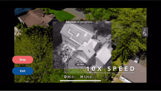
In early 2020, SkyeBrowse introduced 3D mapping through videogrammetry, the process of creating 3D models using one video, instead of hundreds of pictures. This became a force multiplier, which increased the processing speed and accuracy of the models.

Thermal mapping however is a bit different than RGB 3D models. Until recently, first responders mainly relied on expensive satellite imagery for wildfire prediction. The capture speed of photogrammetry is too slow for accurate thermal maps, which has limited the use of this technology. Models are blurred because of the different thermal calibrations throughout the long and tedious process; this happens because FFC (flat field correction) recalibrates after every 5 minutes, changing the emissivity and affecting output.

Videogrammetry is the elegant solution to this problem, as the reality capture is based on a single video which is shot in 90 seconds without camera recalibration. After a long period of research, development and testing, SkyeBrowse has announced a videogrammetry thermal mapping feature in partnership with drone manufacturer, Autel Robotics. This allows for the democratization of 3D modeling, both through visual cameras and non-radiometric thermal cameras.

“Thermal mapping provides countless benefits to firefighting, search and rescue, and night time situational awareness. SkyeBrowse is extremely proud to announce this capability together with Autel and hopes to support first responders even more with its technology”, said CEO of SkyeBrowse, Bobby Ouyang while making the announcement.

Commenting on the partnership, Autel Robotics CEO, Randall Warnas says “We’re excited to be partnering with SkyeBrowse to equip public safety with purpose-built 3D modeling technology. With the new integration, Autel Evo II drones will be able to make 3D models in 90 seconds. We see thermal mapping to be a force multiplier for night time 3D modeling, fire fighting, and SAR.”

Thermal mapping through videogrammetry brings many benefits; the technology will enable determination of hotspots of a fire in near-real time which means fire rescuers can focus their efforts on hotspots early on into the operation. Furthermore, the models also help figure out where the fire will spread to. These two benefits combined with the fact that the model is produced within minutes significantly change how fire departments have used drones and thermal mapping in the past and provide them with a clear advantage in their operations.

thermal mapping

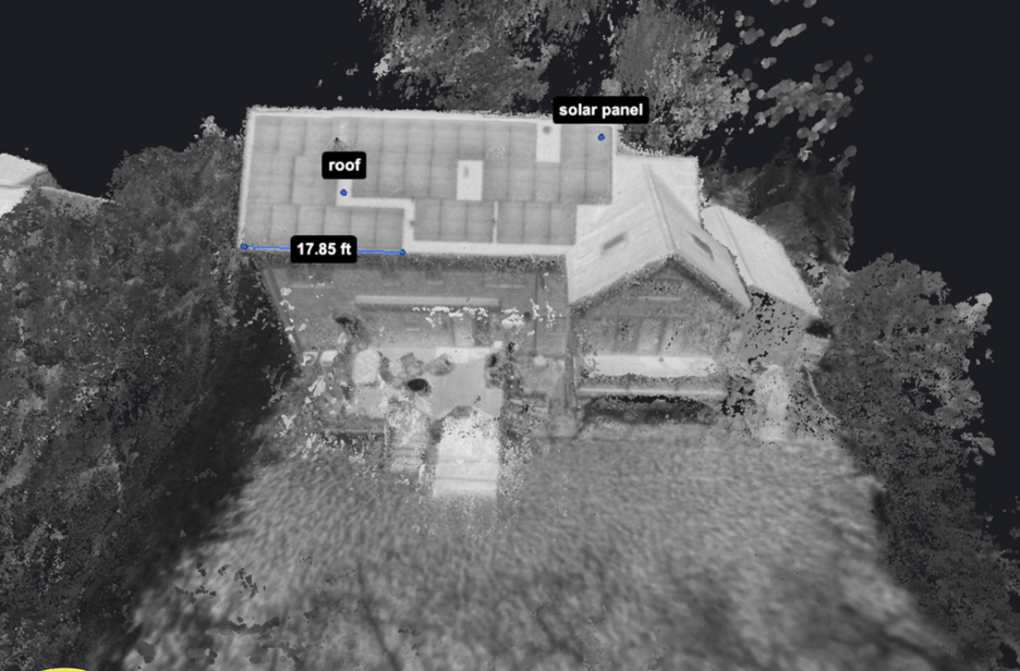
Commenting on thermal mapping, Chief Scott Mlakar of Willoughby Fire Department says, “thermal mapping makes a huge difference in how we deal with various situations. Commercial roof thermal mapping allows us to see the extent of fire spread on large commercial structural fires and get ahead of them in time. It’s also excellent for fire investigations post-fire to map up hotspots and assist with fire watch.” He further added, “Wildfire planning and wildfires thermal mapping allows us to see the entirety of the incident and place resources where they’re needed based upon existing weather conditions and access.”

In practical situations, SkyeBrowse’s patented videogrammetry completes the flight and recording in just 90 seconds and takes up to 10 minutes to produce the model. This enables rapid situation awareness for firefighters.

The benefits of thermal mapping are not limited to fire rescue situations. Amongst other scenarios, thermal mapping can be used in night time accident reconstruction to determine fresh skid and yaw marks. Thermal mapping technology is also useful in tactical flights for SWAT scouts at night and hostage situations.

While the feature is still to be made publicly available, it has already been tested by selected first responders. In case you wish to join the waitlist for early access, you can register here.

Gulraiz is a tech enthusiast having experience in the AI, IoT and the UAS space. He has extensive experience deploying AI initiatives across both the public and private sector and has also been a mentor for Dubai Future Accelerators UAE. Gulraiz is part of the SkyeBrowse team which is responsible for the simplified 2 tap 3D modeling through drones that is helping first responders across the world.


Miriam McNabb

Miriam McNabb is the Editor-in-Chief of DRONELIFE and CEO of JobForDrones, a professional drone services marketplace, and a fascinated observer of the emerging drone industry and the regulatory environment for drones. Miriam has penned over 3,000 articles focused on the commercial drone space and is an international speaker and recognized figure in the industry.  Miriam has a degree from the University of Chicago and over 20 years of experience in high tech sales and marketing for new technologies.
For drone industry consulting or writing, Email Miriam.

TWITTER:@spaldingbarker

Subscribe to DroneLife here.

Filed Under: Drone News Feeds, Featured, Fire, Fire and Police, Firefighter, News Tagged With: Autel, drones for first responders, SkyeBrowse, Thermal mapping

Reader Interactions

Trackbacks

  1. विशेषज्ञों ने अपराध स्थल की जांच के लिए 4 अलग-अलग ड्रोन मैपिंग समाधानों का परीक्षण किया। यहाँ क्य says:
    October 4, 2021 at 5:49 am

    […] स्काई ब्राउज पहली उड़ान थी, जिसमें एक बटन पर कब्जा था। ब्रैडी रीश ने स्काईब्रोस वीडियो मिशन के लिए कैमरे के एक्सपोजर स्तरों को निर्देश देने वाले स्काई ब्राउज डेवलपर के इनपुट के साथ मिशन की स्थापना की। एक बार मिशन पूरा हो जाने के बाद, तस्वीरें स्काई ब्राउज वेबसाइट पर अपलोड कर दी गईं, जहां उड़ान के लगभग 30 मिनट बाद परिणाम मिले। […]

    Reply
  2. Experts Tested 4 Different Drone Mapping Solutions for Crime Scene Investigation. Here’s What Happened. - Summer Of Drones News says:
    September 29, 2021 at 11:44 am

    […] SkyeBrowse had the primary flight, with its one-button seize. Brady Reisch arrange the mission, with enter from the SkyeBrowse developer instructing the publicity ranges of the digital camera for the SkyeBrowse video mission. Once the mission was accomplished, the images have been uploaded to the SkyeBrowse web site, the place outcomes have been discovered roughly half-hour following the flight. […]

    Reply
  3. Experts Tested 4 Different Drone Mapping Solutions for Crime Scene Investigation. Here’s What Happened. - The Drone Page says:
    September 29, 2021 at 11:02 am

    […] SkyeBrowse had the first flight, with its one-button capture. Brady Reisch set up the mission, with input from the SkyeBrowse developer instructing the exposure levels of the camera for the SkyeBrowse video mission. Once the mission was completed, the photos were uploaded to the SkyeBrowse website, where results were found approximately 30 minutes following the flight. […]

    Reply
  4. Videogrammetry for Thermal Mapping – DRONELIFE – Game of Drones says:
    June 7, 2021 at 1:24 am

    […] Article Source […]

    Reply
  5. Videogrammetry for Thermal Mapping: Game Changing Technology for First Responders – Top Drones & reviews says:
    June 6, 2021 at 11:03 pm

    […] post Videogrammetry for Thermal Mapping: Game Changing Technology for First Responders appeared first on […]

    Reply
  6. Videogrammetry for Thermal Mapping – DRONELIFE – My CMS says:
    June 6, 2021 at 8:39 pm

    […] Source link […]

    Reply
  7. Videogrammetry for Thermal Mapping - Go Drones Blog says:
    June 6, 2021 at 8:09 pm

    […] A new partnership between Autel Robotics and SkyeBrowse introduces videogrammetry for thermal mapping, a game changer for public safety. Source […]

    Reply
  8. Videogrammetry for Thermal Mapping - DRONELIFE - Information Dig Site says:
    June 6, 2021 at 7:53 pm

    […] Source link […]

    Reply
  9. Videogrammetry for Thermal Mapping: Game Changing Technology for First Responders – DronePilots.News says:
    June 6, 2021 at 5:25 pm

    […] post Videogrammetry for Thermal Mapping: Game Changing Technology for First Responders appeared first on […]

    Reply
  10. Videogrammetry for Thermal Mapping: Game Changing Technology for First Responders – Drone Observer says:
    June 6, 2021 at 5:04 pm

    […] Source link […]

    Reply

Leave a Reply Cancel reply

Your email address will not be published. Required fields are marked *

Primary Sidebar

LATEST

Titan Protection Receives FAA Approval for One-to-Many Drone Operations

Titan Protection has secured FAA approval to conduct one-to-many drone operations, enabling a single remote pilot to oversee up to…

Continue Reading Titan Protection Receives FAA Approval for One-to-Many Drone Operations

DroneOD Joins Space Park Leicester to Advance Cross-Platform Drone Technologies

DroneOD, a UK start-up developing universal connectivity solutions for unmanned aerial systems, has joined Space Park Leicester at its £100…

Continue Reading DroneOD Joins Space Park Leicester to Advance Cross-Platform Drone Technologies

Autoflight Unveils First 5-Ton Heavy Lift eVTOL Aircraft

AutoFlight has introduced Matrix, the world’s first 5-ton eVTOL aircraft, successfully completing a public full transition flight demonstration at its…

Continue Reading Autoflight Unveils First 5-Ton Heavy Lift eVTOL Aircraft

FAA Signals Tougher Stance on Unauthorized Drone Operations

Agency issues fines, license suspensions, and revocations for unsafe and unauthorized drone operations The Federal Aviation Administration (FAA) took enforcement…

Continue Reading FAA Signals Tougher Stance on Unauthorized Drone Operations

New DIU Project Targets Scalable, Containerized Drone Launch and Recovery Systems

DoD Seeks Automated Infrastructure to Support Large-Scale Autonomous Drone Operations The U.S. Department of Defense (DoD), through the Defense Innovation…

Continue Reading New DIU Project Targets Scalable, Containerized Drone Launch and Recovery Systems

The Companies Tapped for the Pentagon’s Drone Dominance Push

U.S. Department of War Launches Industry Competition for Drone Dominance Program Phase I The U.S. Department of War has formally…

Continue Reading The Companies Tapped for the Pentagon’s Drone Dominance Push

MatrixSpace Expands AI Software Platform to Enable Multi-Sensor, Real-Time Counter-Drone Detection

Updated edge-to-cloud architecture supports early warning, threat assessment, and unified airspace awareness MatrixSpace has announced a major update to its…

Continue Reading MatrixSpace Expands AI Software Platform to Enable Multi-Sensor, Real-Time Counter-Drone Detection

Why “Best-in-Class” Components Aren’t Enough Anymore

How sourcing expectations are changing how drones are engineered Amprius’ newly announced U.S.-based manufacturing partnership with Nanotech Energy is more…

Continue Reading Why “Best-in-Class” Components Aren’t Enough Anymore

SkyDrive to Demonstrate Remotely Piloted eVTOL Operations in Tokyo

Japan-based eVTOL developer SkyDrive Inc. will conduct demonstration flights of its Model SD-05 in Tokyo between February 24 and February…

Continue Reading SkyDrive to Demonstrate Remotely Piloted eVTOL Operations in Tokyo

Chemitek Solar Develops Drone-Compatible Cleaning Solution for Agrivoltaic Systems

Portuguese manufacturer Chemitek Solar has announced the development of its Drone AgroPV Cleaning Agent, a specialized biodegradable cleaning solution engineered…

Continue Reading Chemitek Solar Develops Drone-Compatible Cleaning Solution for Agrivoltaic Systems

Secondary Sidebar

Footer

SPONSORED

Inspired Flight Gremsy IF800 VIO F1 drones geo week

What Will It Take to Strengthen U.S. Drone Manufacturing? A Conversation with Inspired Flight’s CEO

Global Mapper Mobile data collection

Collection Ground Control Points with Global Mapper Mobile

Military Drone Mapping Solutions

How SimActive’s Correlator3D™ is Revolutionizing Military Mapping: An Exclusive Interview with CEO Philippe Simard

Photogrammetry Accuracy Standards

SimActive Photogrammetry Software: Enabling Users to Meet Accuracy Standards for Over 20 Years

NACT Engineering Parrot ANAFI tether indoor shot

Smart Tether for Parrot ANAFI USA from NACT Engineering

Blue Marble, features global mapper, features Blue Marble

Check Out These New Features in Global Mapper v25 from Blue Marble

About Us | Contact Us | Advertise With Us | Write for Us | Privacy Policy | Terms of Service

The Trusted Source for the Business of Drones.

This website uses cookies and third party services. By clicking OK, you are agreeing to our privacy policy. ACCEPT

Manage consent

Privacy Overview

This website uses cookies to improve your experience while you navigate through the website. Out of these, the cookies that are categorized as necessary are stored on your browser as they are essential for the working of basic functionalities of the website. We also use third-party cookies that help us analyze and understand how you use this website. These cookies will be stored in your browser only with your consent. You also have the option to opt-out of these cookies. But opting out of some of these cookies may affect your browsing experience.
Necessary
Always Enabled
Necessary cookies are absolutely essential for the website to function properly. These cookies ensure basic functionalities and security features of the website, anonymously.
CookieDurationDescription
cookielawinfo-checkbox-analytics11 monthsThis cookie is set by GDPR Cookie Consent plugin. The cookie is used to store the user consent for the cookies in the category "Analytics".
cookielawinfo-checkbox-functional11 monthsThe cookie is set by GDPR cookie consent to record the user consent for the cookies in the category "Functional".
cookielawinfo-checkbox-necessary11 monthsThis cookie is set by GDPR Cookie Consent plugin. The cookies is used to store the user consent for the cookies in the category "Necessary".
cookielawinfo-checkbox-others11 monthsThis cookie is set by GDPR Cookie Consent plugin. The cookie is used to store the user consent for the cookies in the category "Other.
cookielawinfo-checkbox-performance11 monthsThis cookie is set by GDPR Cookie Consent plugin. The cookie is used to store the user consent for the cookies in the category "Performance".
viewed_cookie_policy11 monthsThe cookie is set by the GDPR Cookie Consent plugin and is used to store whether or not user has consented to the use of cookies. It does not store any personal data.
Functional
Functional cookies help to perform certain functionalities like sharing the content of the website on social media platforms, collect feedbacks, and other third-party features.
Performance
Performance cookies are used to understand and analyze the key performance indexes of the website which helps in delivering a better user experience for the visitors.
Analytics
Analytical cookies are used to understand how visitors interact with the website. These cookies help provide information on metrics the number of visitors, bounce rate, traffic source, etc.
Advertisement
Advertisement cookies are used to provide visitors with relevant ads and marketing campaigns. These cookies track visitors across websites and collect information to provide customized ads.
Others
Other uncategorized cookies are those that are being analyzed and have not been classified into a category as yet.
SAVE & ACCEPT