• Skip to main content
  • Skip to secondary menu
  • Skip to primary sidebar
  • Skip to secondary sidebar
  • Skip to footer
  • DroneRacingLife
  • DroneFlyers
  • Newsletter
DroneLife

DRONELIFE

Stay up to date on all the latest Drone News

  • News
  • Products
  • Industries
    • Agriculture
    • Construction
    • Delivery
    • Dual Use
    • Inspection
    • Public Safety
    • Surveying
  • Enthusiasts
  • Regulations
  • Business
  • Video
  • Podcasts

A Smarter City Model: Harrow’s Digital Twin Delivers Real-World Results

April 14, 2026 by Miriam McNabb 1 Comment

New approach reduces maintenance costs and improves planning, engagement, and public services

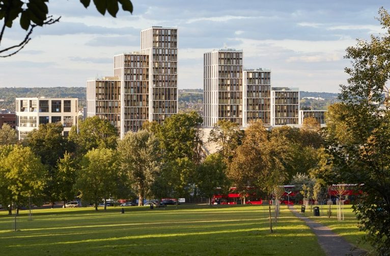
The London Borough of Harrow has launched an expanded digital twin of the city, using drone data to improve maintenance, planning, and public engagement. The project combines high-resolution drone imagery with existing lower-resolution data to create a more detailed and cost-effective digital model of the borough.

Harrow digital twin drone data

Using Site Scan drone software from Esri UK, Harrow is capturing and processing aerial data to build 3D models of key assets. These include parks, leisure centers, historic buildings, and other public infrastructure.

Reducing Costs and Improving Maintenance

The digital twin is already delivering measurable cost savings. Harrow used drone imagery to inspect the roof of Headstone Manor & Museum, a historic building dating back to 1310. This approach replaced traditional scaffolding and manual inspections.

The result was a savings of £12,000 on a single project.

Harrow digital twin drone data

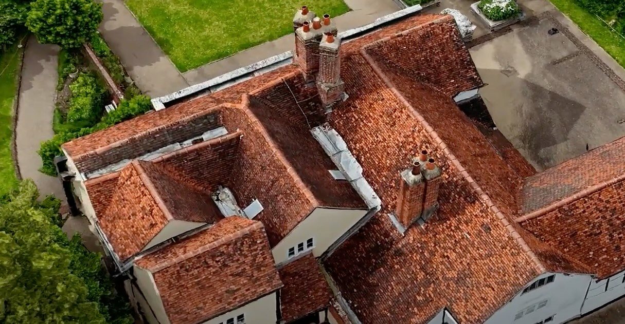
Ben Jones, Head of Digital at London Borough of Harrow, said: “The new drone approach is already saving time and money and fits our mission to work smarter and more efficiently. With minimal investment, the 3D data has the potential to deliver significant financial benefits over the next few years.”

The council is using a hybrid model. High-resolution drone data adds detail where needed, while existing lower-resolution data covers the wider area. This approach helps control costs while improving accuracy.

“Using a drone and Site Scan gives us a faster and more cost-effective method of examining our buildings and other assets,” commented Sam Tizzard, Head of GIS and Data Manager at London Borough of Harrow. “The hybrid approach using high and low resolution data keeps development costs down but delivers detail where it matters most. It’s a low cost, low risk strategy for creating a digital twin to drive significant time and cost savings. The potential for ongoing savings in roof inspections alone is huge.”

Expanding Use Cases Across the Borough

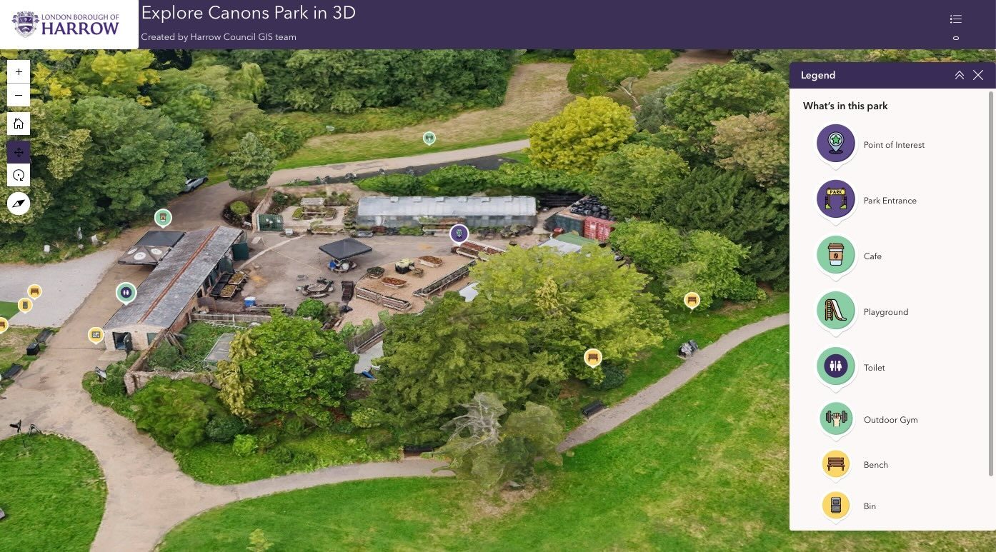
Harrow is also using its digital twin to support public engagement and environmental initiatives. Interactive 3D maps and 360-degree imagery are helping residents explore parks and public spaces online.

Canons Park is one of the first locations to use this approach. The project is part of the Healthier Harrow program, which aims to promote well-being and increase the use of green spaces.

Harrow digital twin drone data
 

The council is also testing drone-based mapping to address fly-tipping. High-resolution 3D images help identify problem areas and guide the placement of signage, fencing, and CCTV systems.

The Broader Role of Digital Twins in Cities

Harrow’s project reflects a wider trend in urban management. Cities around the world are building digital twins to improve planning and operations.

These models support a range of use cases beyond maintenance. Digital twins can help cities plan for floods and other natural disasters by simulating water flow and infrastructure stress. They also support resilience planning by identifying weak points in critical systems before failures occur.

In addition, digital twins play a role in preserving cultural heritage. High-resolution 3D models allow cities to document historic buildings and monuments in detail. This creates a permanent record and supports restoration efforts if damage occurs.

Urban planners also use digital twins to test new developments. They can model traffic patterns, analyze environmental impact, and improve land use decisions. In public safety, digital twins help agencies plan emergency response routes and coordinate resources more effectively.

Building Toward Real-Time Insights

Harrow plans to expand its digital twin with additional data sources and capabilities. Future steps include integrating BIM models and adding real-time data such as traffic and weather conditions.

The council is also training more staff as drone pilots to meet growing demand for aerial data.

“By making digital twins more affordable with drones and Site Scan, London Borough of Harrow is enabling smarter asset management, better planning and improved services for residents,” commented Paul Clarke, Head of Government at Esri UK.

As cities look to balance cost, efficiency, and service quality, Harrow’s approach offers a practical model. By combining drones with existing data systems, the borough is building a scalable digital twin that supports both immediate needs and long-term planning.

Read more:

  • From Intergeo 2025: Digital Twin Technology Preserves Alcatraz Island
  • Aechelon Techology Announces New Whole-Earth Digital Twin Project Orbion
  • Should Coachella be Using Drones and Digital Twins for Security? The New Standard in Event Management
Miriam McNabb

Miriam McNabb is the Editor-in-Chief of DRONELIFE and CEO of JobForDrones, a professional drone services marketplace, and a fascinated observer of the emerging drone industry and the regulatory environment for drones. Miriam has penned over 3,000 articles focused on the commercial drone space and is an international speaker and recognized figure in the industry.  Miriam has a degree from the University of Chicago and over 20 years of experience in high tech sales and marketing for new technologies.
For drone industry consulting or writing, Email Miriam.

TWITTER:@spaldingbarker

Subscribe to DroneLife here.

Filed Under: Applications, Data analytics, Digital Twins, Drone News, Drone News Feeds, Mapping, News, Products, Smart Cities, UK Drone Industry Tagged With: 3d mapping, asset management, city infrastructure, digital twin, drone data, drone inspections, drone mapping, Esri Site Scan, GIS, public sector drones, smart cities, UK drones, urban planning

Reader Interactions

Comments

  1. Sam Rivera says

    May 18, 2026 at 3:14 am

    Came across this while researching — glad I did. Very informative. interesting find

    Reply

Leave a Reply Cancel reply

Your email address will not be published. Required fields are marked *

Primary Sidebar

LATEST

5 Federal Drone Policies Flying Under the Radar This Summer

From World Cup airspace restrictions to critical infrastructure rulemaking, several federal initiatives could shape the drone industry in the months…

Continue Reading 5 Federal Drone Policies Flying Under the Radar This Summer

Drone Industry Insights Launches the 9th Edition of the Global Drone Survey — The World’s Largest Annual Industry Survey for the Drone Market

Survey open to all actors in the global drone market ecosystem — manufacturers, operators, investors, associations, regulators, and service providers…

Continue Reading Drone Industry Insights Launches the 9th Edition of the Global Drone Survey — The World’s Largest Annual Industry Survey for the Drone Market

Proposed Patent Bill Could Have Major Implications for Drone Industry Intellectual Property

Prohibiting Adversarial Patents Act would make certain patents unenforceable while leaving ownership intact A newly introduced bill in Congress concerning…

Continue Reading Proposed Patent Bill Could Have Major Implications for Drone Industry Intellectual Property

Seattle Stadium “No-Drone Zone” During FIFA Matches

By Dronelife Features Editor Jim Magill Federal officials on Monday urged drone operators to stay away from Lumen Field, which…

Continue Reading Seattle Stadium “No-Drone Zone” During FIFA Matches

Landair Surveys Uses SimActive Correlator3D for Planned Burns Mapping in Australia

The Australian geospatial firm is using Correlator3D to generate orthomosaics from aerial imagery captured for wildfire prevention and land management…

Continue Reading Landair Surveys Uses SimActive Correlator3D for Planned Burns Mapping in Australia

As Disaster Risks Grow, WingXpand and Verizon Explore New Tools for Emergency Response

WingXpand will work with Verizon Frontline and emergency teams to explore new tools for disaster assessment and community resilience As…

Continue Reading As Disaster Risks Grow, WingXpand and Verizon Explore New Tools for Emergency Response

HOVERAir’s UK Launch Raises a Bigger Question: Who Will Serve America’s Consumer Drone Market?

HOVERAir has announced the UK launch of its new X1 Smart, a 99-gram self-flying camera designed to make aerial content…

Continue Reading HOVERAir’s UK Launch Raises a Bigger Question: Who Will Serve America’s Consumer Drone Market?

DRONELIFE Exclusive Interview: Inside PDW’s Strategy to Build Drones That Can Operate When GPS and Communications Fail

PDW works to develop advanced drone communications systems By DRONELIFE Features Editor Jim Magill As modern warfare increasingly relies on…

Continue Reading DRONELIFE Exclusive Interview: Inside PDW’s Strategy to Build Drones That Can Operate When GPS and Communications Fail

AirData UAV and LeoSight Bring Live Drone Data for DFR Programs

The new LeoSight AirData integration streams real-time flight data, telemetry, and operational insights from AirData directly into LeoCommand, giving dispatchers…

Continue Reading AirData UAV and LeoSight Bring Live Drone Data for DFR Programs

New Boson SX8 Brings High-Resolution Thermal Imaging to NDAA-Compliant Drone Payloads

New thermal imaging module combines SXGA resolution with compact size and U.S. manufacturing Teledyne FLIR OEM has announced the Boson…

Continue Reading New Boson SX8 Brings High-Resolution Thermal Imaging to NDAA-Compliant Drone Payloads

Secondary Sidebar

Footer

SPONSORED

Inspired Flight Gremsy IF800 VIO F1 drones geo week

What Will It Take to Strengthen U.S. Drone Manufacturing? A Conversation with Inspired Flight’s CEO

Global Mapper Mobile data collection

Collection Ground Control Points with Global Mapper Mobile

Military Drone Mapping Solutions

How SimActive’s Correlator3D™ is Revolutionizing Military Mapping: An Exclusive Interview with CEO Philippe Simard

Photogrammetry Accuracy Standards

SimActive Photogrammetry Software: Enabling Users to Meet Accuracy Standards for Over 20 Years

NACT Engineering Parrot ANAFI tether indoor shot

Smart Tether for Parrot ANAFI USA from NACT Engineering

Blue Marble, features global mapper, features Blue Marble

Check Out These New Features in Global Mapper v25 from Blue Marble

About Us | Contact Us | Advertise With Us | Write for Us | Privacy Policy | Terms of Service

The Trusted Source for the Business of Drones.

This website uses cookies and third party services. By clicking OK, you are agreeing to our privacy policy. ACCEPT

Manage consent

Privacy Overview

This website uses cookies to improve your experience while you navigate through the website. Out of these, the cookies that are categorized as necessary are stored on your browser as they are essential for the working of basic functionalities of the website. We also use third-party cookies that help us analyze and understand how you use this website. These cookies will be stored in your browser only with your consent. You also have the option to opt-out of these cookies. But opting out of some of these cookies may affect your browsing experience.
Necessary
Always Enabled
Necessary cookies are absolutely essential for the website to function properly. These cookies ensure basic functionalities and security features of the website, anonymously.
CookieDurationDescription
cookielawinfo-checkbox-analytics11 monthsThis cookie is set by GDPR Cookie Consent plugin. The cookie is used to store the user consent for the cookies in the category "Analytics".
cookielawinfo-checkbox-functional11 monthsThe cookie is set by GDPR cookie consent to record the user consent for the cookies in the category "Functional".
cookielawinfo-checkbox-necessary11 monthsThis cookie is set by GDPR Cookie Consent plugin. The cookies is used to store the user consent for the cookies in the category "Necessary".
cookielawinfo-checkbox-others11 monthsThis cookie is set by GDPR Cookie Consent plugin. The cookie is used to store the user consent for the cookies in the category "Other.
cookielawinfo-checkbox-performance11 monthsThis cookie is set by GDPR Cookie Consent plugin. The cookie is used to store the user consent for the cookies in the category "Performance".
viewed_cookie_policy11 monthsThe cookie is set by the GDPR Cookie Consent plugin and is used to store whether or not user has consented to the use of cookies. It does not store any personal data.
Functional
Functional cookies help to perform certain functionalities like sharing the content of the website on social media platforms, collect feedbacks, and other third-party features.
Performance
Performance cookies are used to understand and analyze the key performance indexes of the website which helps in delivering a better user experience for the visitors.
Analytics
Analytical cookies are used to understand how visitors interact with the website. These cookies help provide information on metrics the number of visitors, bounce rate, traffic source, etc.
Advertisement
Advertisement cookies are used to provide visitors with relevant ads and marketing campaigns. These cookies track visitors across websites and collect information to provide customized ads.
Others
Other uncategorized cookies are those that are being analyzed and have not been classified into a category as yet.
SAVE & ACCEPT