New software stack combines AI, thermal imaging, and computational imaging to improve ground-based intelligence, surveillance, and reconnaissance Teledyne FLIR OEM has introduced Prism™ Ground ISR, a new AI-powered software stack designed to improve ground-based intelligence, surveillance, and reconnaissance (ISR) missions. The new release extends the company's Prism software … [Read more...] about Teledyne FLIR OEM Expands Prism AI Platform with Ground ISR Software for Military Target Classification
Data analytics
A Smarter City Model: Harrow’s Digital Twin Delivers Real-World Results

New approach reduces maintenance costs and improves planning, engagement, and public services The London Borough of Harrow has launched an expanded digital twin of the city, using drone data to improve maintenance, planning, and public engagement. The project combines high-resolution drone imagery with existing lower-resolution data to create a more detailed and cost-effective … [Read more...] about A Smarter City Model: Harrow’s Digital Twin Delivers Real-World Results
Blue Marble Shows How AI and LiDAR Deliver ROI for Rail Operators
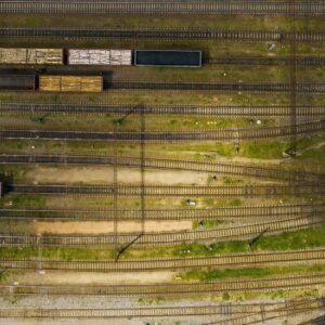
A New Moment for BVLOS Operations Drone operators in the U.S. now have more access to Beyond Visual Line of Sight (BVLOS) waivers than ever before. These waivers allow a single operator to fly longer routes without placing observers along the entire path. The FAA’s recent publication of the BVLOS Notice of Proposed Rulemaking (NPRM) also marks the first step toward routine … [Read more...] about Blue Marble Shows How AI and LiDAR Deliver ROI for Rail Operators
Managing Large Photogrammetry Projects Simultaneously: Can It Be Done?

How scalable workflows, automation, and distributed processing make managing large photogrammetry projects possible. DRONELIFE spoke with Philippe Simard, co-founder and CEO of SimActive, the Canadian company behind the Correlator3D photogrammetry suite, to explore one of the most pressing challenges in the aerial mapping industry: how to efficiently manage and process … [Read more...] about Managing Large Photogrammetry Projects Simultaneously: Can It Be Done?
SimActive Enables 3D Calculations from Drone Imagery at Mining Sites

Correlator3D Software Streamlines Volume Measurements and Terrain Analysis SimActive Inc. has announced that its Correlator3D™ software is being used in Germany to generate volumetric calculations from drone imagery. The technology creates dense point clouds at mining sites, enabling accurate volume measurements and detailed terrain analysis. Improving Mining Operations … [Read more...] about SimActive Enables 3D Calculations from Drone Imagery at Mining Sites


