• Skip to main content
  • Skip to secondary menu
  • Skip to primary sidebar
  • Skip to secondary sidebar
  • Skip to footer
  • DroneRacingLife
  • DroneFlyers
  • Newsletter
DroneLife

DRONELIFE

Stay up to date on all the latest Drone News

  • News
  • Products
  • Industries
    • Agriculture
    • Construction
    • Delivery
    • Dual Use
    • Inspection
    • Public Safety
    • Surveying
  • Enthusiasts
  • Regulations
  • Business
  • Video
  • Podcasts

US Army Corps of Engineers Deploys SimActive’s Correlator3D for Coastal Corridor Mapping

March 20, 2025 by Miriam McNabb Leave a Comment

Correlator3D streamlines image processing for the Joint Airborne Lidar Bathymetry Technical Center of Expertise, enhancing topo-bathy lidar mapping efficiency.

by DRONELIFE Staff Writer Ian J. McNabb

SimActive Inc. recently announced that their Correlator3D product was deployed by the US Army Corps of Engineers for corridor mapping. The software is used to process imagery and create mapping products in conjunction with topo-bathy lidar systems.

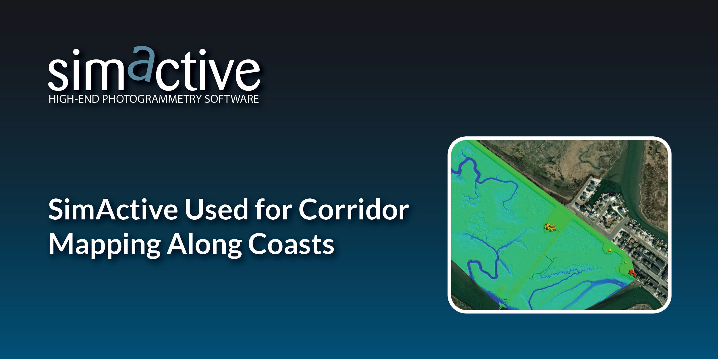
As part of the Corps of Engineers, the Joint Airborne Lidar Bathymetry Technical Center of Expertise (JALBTCX) uses an advanced set of sensors and mapping tools to accurately reproduce the United States’ extensive coastline. According to Simactive’s press release, in combination with topo-bathy lidar, imagery is collected with a Phase One 150MP camera. Surfaces are generated from the lidar data and imported into Correlator 3D along with the imagery to rapidly produce blocks of orthomosaics used for all types of assessments.

“Correlator3D is by far the easiest to use and fastest image processing software out there”, said J. Heath Harwood, Physical Scientist at the US Army Corps of Engineers. “Its DEM editing and mosaic editing tools are outstanding.”

Simactive CEO Phillippe Simard sat down with DroneLife a few months ago to discuss Correlator3D’s military applications. “The Canadian army was involved in Afghanistan back then. They had team rotations every six months. It took way too long to train their personnel for doing photogrammetry. They were looking for a simpler and faster photogrammetry suite. They gave us a multi-year contract to develop that capability for them.” Simactive’s rapid processing technology aligns perfectly with the military’s need for quick and intuitive mapping solutions, both for large infrastructure projects and drill/field operations.

Simactive recently announced the newest version of Correlator3D, 10.3, focusing on optimizations for large projects (like the kind of mapping being conducted by the Corps), making their solution even more streamlined and efficient.

“Optimizations made in Version 10.3 greatly enhance user experience when working with very large projects,” said Louis Simard, CTO at SimActive. “Having a fluidity when dealing with huge datasets not only improves user experience, but also allows for the processing of even more extensive projects.”

More information on Simactive and Correlator3D is available here.

Want DRONELIFE news delivered to your inbox every weekday?  Sign up here.

Read more:

  • Enhancing Drone Mapping with RTK and PPK: Insights from SimActive’s Eric Andelin
  • SimActive and Air Data Solutions Enhance Oil & Gas Mapping with High-Resolution Aerial Imagery
  • SimActive’s Correlator3D™ 10.3: Revolutionizing Large-Scale Mapping with Enhanced Speed and Flexibility


Miriam McNabb

Miriam McNabb is the Editor-in-Chief of DRONELIFE and CEO of JobForDrones, a professional drone services marketplace, and a fascinated observer of the emerging drone industry and the regulatory environment for drones. Miriam has penned over 3,000 articles focused on the commercial drone space and is an international speaker and recognized figure in the industry.  Miriam has a degree from the University of Chicago and over 20 years of experience in high tech sales and marketing for new technologies.
For drone industry consulting or writing, Email Miriam.

TWITTER:@spaldingbarker

Subscribe to DroneLife here.

Filed Under: Drone News, Drone News Feeds, Featured - Surveying, News Tagged With: aerial imagery processing, coastal mapping, correlator3d, geospatial technology, LiDAR mapping, orthomosaic generation, photogrammetry software, SimActive, topo-bathy lidar, US Army Corps mapping

Reader Interactions

Leave a Reply Cancel reply

Your email address will not be published. Required fields are marked *

Primary Sidebar

LATEST

Titan Protection Receives FAA Approval for One-to-Many Drone Operations

Titan Protection has secured FAA approval to conduct one-to-many drone operations, enabling a single remote pilot to oversee up to…

Continue Reading Titan Protection Receives FAA Approval for One-to-Many Drone Operations

DroneOD Joins Space Park Leicester to Advance Cross-Platform Drone Technologies

DroneOD, a UK start-up developing universal connectivity solutions for unmanned aerial systems, has joined Space Park Leicester at its £100…

Continue Reading DroneOD Joins Space Park Leicester to Advance Cross-Platform Drone Technologies

Autoflight Unveils First 5-Ton Heavy Lift eVTOL Aircraft

AutoFlight has introduced Matrix, the world’s first 5-ton eVTOL aircraft, successfully completing a public full transition flight demonstration at its…

Continue Reading Autoflight Unveils First 5-Ton Heavy Lift eVTOL Aircraft

FAA Signals Tougher Stance on Unauthorized Drone Operations

Agency issues fines, license suspensions, and revocations for unsafe and unauthorized drone operations The Federal Aviation Administration (FAA) took enforcement…

Continue Reading FAA Signals Tougher Stance on Unauthorized Drone Operations

New DIU Project Targets Scalable, Containerized Drone Launch and Recovery Systems

DoD Seeks Automated Infrastructure to Support Large-Scale Autonomous Drone Operations The U.S. Department of Defense (DoD), through the Defense Innovation…

Continue Reading New DIU Project Targets Scalable, Containerized Drone Launch and Recovery Systems

The Companies Tapped for the Pentagon’s Drone Dominance Push

U.S. Department of War Launches Industry Competition for Drone Dominance Program Phase I The U.S. Department of War has formally…

Continue Reading The Companies Tapped for the Pentagon’s Drone Dominance Push

MatrixSpace Expands AI Software Platform to Enable Multi-Sensor, Real-Time Counter-Drone Detection

Updated edge-to-cloud architecture supports early warning, threat assessment, and unified airspace awareness MatrixSpace has announced a major update to its…

Continue Reading MatrixSpace Expands AI Software Platform to Enable Multi-Sensor, Real-Time Counter-Drone Detection

Why “Best-in-Class” Components Aren’t Enough Anymore

How sourcing expectations are changing how drones are engineered Amprius’ newly announced U.S.-based manufacturing partnership with Nanotech Energy is more…

Continue Reading Why “Best-in-Class” Components Aren’t Enough Anymore

SkyDrive to Demonstrate Remotely Piloted eVTOL Operations in Tokyo

Japan-based eVTOL developer SkyDrive Inc. will conduct demonstration flights of its Model SD-05 in Tokyo between February 24 and February…

Continue Reading SkyDrive to Demonstrate Remotely Piloted eVTOL Operations in Tokyo

Chemitek Solar Develops Drone-Compatible Cleaning Solution for Agrivoltaic Systems

Portuguese manufacturer Chemitek Solar has announced the development of its Drone AgroPV Cleaning Agent, a specialized biodegradable cleaning solution engineered…

Continue Reading Chemitek Solar Develops Drone-Compatible Cleaning Solution for Agrivoltaic Systems

Secondary Sidebar

Footer

SPONSORED

Inspired Flight Gremsy IF800 VIO F1 drones geo week

What Will It Take to Strengthen U.S. Drone Manufacturing? A Conversation with Inspired Flight’s CEO

Global Mapper Mobile data collection

Collection Ground Control Points with Global Mapper Mobile

Military Drone Mapping Solutions

How SimActive’s Correlator3D™ is Revolutionizing Military Mapping: An Exclusive Interview with CEO Philippe Simard

Photogrammetry Accuracy Standards

SimActive Photogrammetry Software: Enabling Users to Meet Accuracy Standards for Over 20 Years

NACT Engineering Parrot ANAFI tether indoor shot

Smart Tether for Parrot ANAFI USA from NACT Engineering

Blue Marble, features global mapper, features Blue Marble

Check Out These New Features in Global Mapper v25 from Blue Marble

About Us | Contact Us | Advertise With Us | Write for Us | Privacy Policy | Terms of Service

The Trusted Source for the Business of Drones.

This website uses cookies and third party services. By clicking OK, you are agreeing to our privacy policy. ACCEPT

Manage consent

Privacy Overview

This website uses cookies to improve your experience while you navigate through the website. Out of these, the cookies that are categorized as necessary are stored on your browser as they are essential for the working of basic functionalities of the website. We also use third-party cookies that help us analyze and understand how you use this website. These cookies will be stored in your browser only with your consent. You also have the option to opt-out of these cookies. But opting out of some of these cookies may affect your browsing experience.
Necessary
Always Enabled
Necessary cookies are absolutely essential for the website to function properly. These cookies ensure basic functionalities and security features of the website, anonymously.
CookieDurationDescription
cookielawinfo-checkbox-analytics11 monthsThis cookie is set by GDPR Cookie Consent plugin. The cookie is used to store the user consent for the cookies in the category "Analytics".
cookielawinfo-checkbox-functional11 monthsThe cookie is set by GDPR cookie consent to record the user consent for the cookies in the category "Functional".
cookielawinfo-checkbox-necessary11 monthsThis cookie is set by GDPR Cookie Consent plugin. The cookies is used to store the user consent for the cookies in the category "Necessary".
cookielawinfo-checkbox-others11 monthsThis cookie is set by GDPR Cookie Consent plugin. The cookie is used to store the user consent for the cookies in the category "Other.
cookielawinfo-checkbox-performance11 monthsThis cookie is set by GDPR Cookie Consent plugin. The cookie is used to store the user consent for the cookies in the category "Performance".
viewed_cookie_policy11 monthsThe cookie is set by the GDPR Cookie Consent plugin and is used to store whether or not user has consented to the use of cookies. It does not store any personal data.
Functional
Functional cookies help to perform certain functionalities like sharing the content of the website on social media platforms, collect feedbacks, and other third-party features.
Performance
Performance cookies are used to understand and analyze the key performance indexes of the website which helps in delivering a better user experience for the visitors.
Analytics
Analytical cookies are used to understand how visitors interact with the website. These cookies help provide information on metrics the number of visitors, bounce rate, traffic source, etc.
Advertisement
Advertisement cookies are used to provide visitors with relevant ads and marketing campaigns. These cookies track visitors across websites and collect information to provide customized ads.
Others
Other uncategorized cookies are those that are being analyzed and have not been classified into a category as yet.
SAVE & ACCEPT