• Skip to main content
  • Skip to secondary menu
  • Skip to primary sidebar
  • Skip to secondary sidebar
  • Skip to footer
  • DroneRacingLife
  • DroneFlyers
  • Newsletter
DroneLife

DRONELIFE

Stay up to date on all the latest Drone News

  • News
  • Products
  • Industries
    • Agriculture
    • Construction
    • Delivery
    • Dual Use
    • Inspection
    • Public Safety
    • Surveying
  • Enthusiasts
  • Regulations
  • Business
  • Video
  • Podcasts

Wingcopter Expands into Long-Range LiDAR Surveying

February 10, 2025 by Miriam McNabb 1 Comment

New Application Enables Efficient Infrastructure and Terrain Mapping

Wingcopter has announced an expansion of its offerings to include long-range beyond visual line of sight (BVLOS) LiDAR surveying solutions. The Wingcopter 198, the company’s flagship drone, will be equipped with advanced laser scanning and camera systems to enable rapid, high-quality data collection.

LiDAR surveying solution Wingcopter

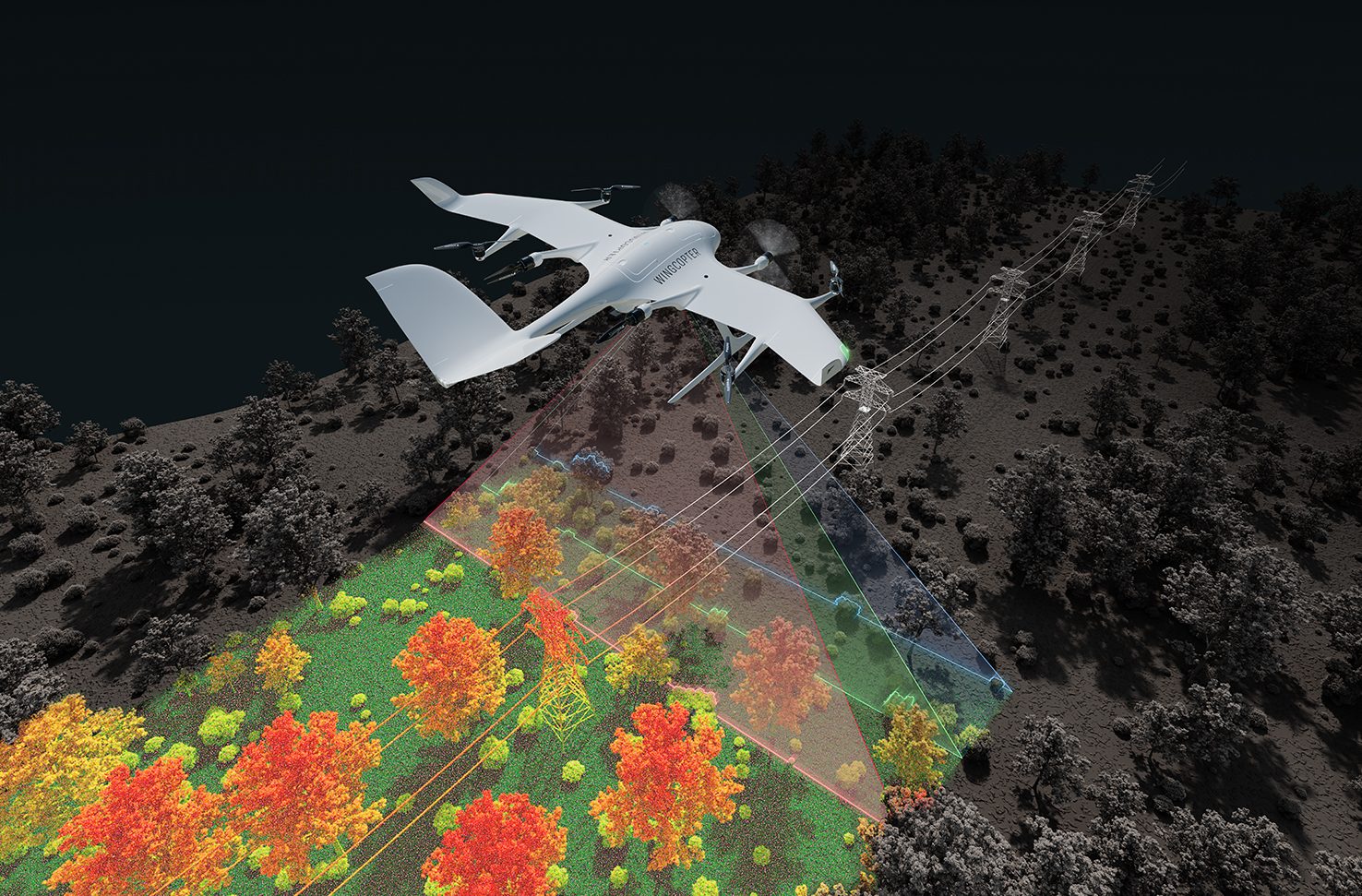
The new system allows customers to survey up to 37 miles (60 km) of infrastructure in one mission while carrying a 10 lbs (4.5 kg) sensor system. This capability makes it suitable for inspecting power lines, pipelines, railways, and roads, as well as mapping difficult-to-access terrain and vegetation.

Announcement at GEO WEEK

The announcement took place at GEO WEEK in Denver, Colorado, a trade show focused on geospatial technology. Wingcopter is showcasing the new application at the event, highlighting its capabilities in high-accuracy mapping. The planned system can collect up to 570 pts/m² with a sensor accuracy of 10 mm and a precision of 5 mm. Using a high-end LiDAR sensor, the Wingcopter 198 can scan up to 2,560 acres (10.3 square kilometers) in a single 42-minute BVLOS mission.

Ansgar Kadura, Co-Founder and Chief Strategy Officer at Wingcopter, stated: “After years of developing and relentless testing, we have frozen the Wingcopter 198 in the configuration that is currently undergoing FAA type certification in the United States. The drone has unique payload and range characteristics, and with a proven product lifetime of more than 1,000 flight hours, it is one of the most reliable long-range eVTOL UAS on the market. Based on this configuration, we are developing a solution to address the field of high-quality LiDAR surveying and integrating the best commercially available sensor systems. I look forward to discussing with surveyors and learning about their vision for an ideal BVLOS LiDAR surveying drone.”

Growing Interest in Brazil

There is strong interest in Wingcopter’s surveying solutions in Brazil. Synerjet, Wingcopter’s authorized local partner, plans to deploy fleets of Wingcopter 198 drones in the surveying market.

Augustinho Simoes, Synerjet’s Director of Drone Operations and Development, explained: “Together with Wingcopter, we are developing custom applications, adding more functionality to the aircraft and meeting requirements from other industries, such as asset inspections, vegetation monitoring and mapping. The first version will be equipped with a high-end LiDAR sensor that offers a wide 100-degree field of view and an extremely high pulse repetition rate of up to 2.4 MHz. The measuring beam is emitted consecutively in three different directions: it alternates from strictly nadir to +10 degrees forward, and to -10 degrees backward. This allows data acquisition with unparalleled completeness in data capture, especially in challenging environments with vertical surfaces, narrow canyons, transmission lines, railways, highways, forest plantations and many other applications.”

Those interested in Wingcopter’s LiDAR surveying capabilities and potential partnerships can find more details at www.wingcopter.com/surveying.

For additional details on Wingcopter and its technology, visit www.wingcopter.com.

Want DRONELIFE news delivered to your inbox every weekday?  Sign up here.

Read more:

  • Wingcopter and ITOCHU Advance Drone Delivery in Japan with New Certification Process
  • Wingcopter Drone Delivery in Africa: Lab Samples, Medical Supplies
  • More Powerful, Still Emission Free: ZAL GmbH Partners with Wingcopter for Hydrogen Drone Project


Miriam McNabb

Miriam McNabb is the Editor-in-Chief of DRONELIFE and CEO of JobForDrones, a professional drone services marketplace, and a fascinated observer of the emerging drone industry and the regulatory environment for drones. Miriam has penned over 3,000 articles focused on the commercial drone space and is an international speaker and recognized figure in the industry.  Miriam has a degree from the University of Chicago and over 20 years of experience in high tech sales and marketing for new technologies.
For drone industry consulting or writing, Email Miriam.

TWITTER:@spaldingbarker

Subscribe to DroneLife here.

Filed Under: Drone News, Drone News Feeds, Featured - Surveying, News, Products, Sensors, Surveying Tagged With: aerial data collection, BVLOS drone, drone mapping, eVTOL drone, geospatial technology, infrastructure inspection, LiDAR surveying, pipeline inspection, UAV surveying, Wingcopter

Reader Interactions

Comments

  1. Joseph says

    March 26, 2025 at 9:54 am

    Interesting article

    Reply

Leave a Reply Cancel reply

Your email address will not be published. Required fields are marked *

Primary Sidebar

LATEST

Teledyne FLIR OEM Upgrades Prism SKR Software for Autonomous Target Recognition

New release combines mission execution and intelligent supervision in a single autonomy platform Teledyne FLIR OEM has announced an upgrade…

Continue Reading Teledyne FLIR OEM Upgrades Prism SKR Software for Autonomous Target Recognition

Drone Operations Software Company AirHub Closes €4.4M Series A

AirHub, a European drone operations software company based in The Hague, has closed a €4.4 million Series A funding round.…

Continue Reading Drone Operations Software Company AirHub Closes €4.4M Series A

Arrive AI Patents Shared Drone Delivery Endpoint With Tenth U.S. Patent

Arrive AI (NASDAQ: ARAI) has secured its tenth U.S. patent, strengthening its intellectual property portfolio for autonomous drone delivery infrastructure.…

Continue Reading Arrive AI Patents Shared Drone Delivery Endpoint With Tenth U.S. Patent

Korean eVTOL Developer Airbility Partners on UAV Public Safety in Thailand

South Korean eVTOL developer Airbility has signed a four-party Memorandum of Understanding to deploy UAV systems for public safety and…

Continue Reading Korean eVTOL Developer Airbility Partners on UAV Public Safety in Thailand

Is U.S. Manufacturing the Answer? SKYROVER Signals a New Strategy as FCC Pressure Mounts

A Hong Kong-based drone company outlines a five-year U.S. roadmap, raising questions about compliance, supply chains, and market access A…

Continue Reading Is U.S. Manufacturing the Answer? SKYROVER Signals a New Strategy as FCC Pressure Mounts

Blue Marble Geographics and Avenza Systems Combine to Create Unified Geospatial Platform

Merger connects office-based analysis with field operations for end-to-end spatial workflows Blue Marble Geographics and Avenza Systems, Inc. have announced…

Continue Reading Blue Marble Geographics and Avenza Systems Combine to Create Unified Geospatial Platform

Amazon Prime Air Adjusts Course After Richardson Setbacks

After rocky start in Texas city, Amazon Air service flying high By DRONELIFE Features Editor Jim Magill After only a…

Continue Reading Amazon Prime Air Adjusts Course After Richardson Setbacks

Airspace Security at 2026 JUNO Awards

RF-Cyber counter-drone system enables non-disruptive protection for large public event D-Fend Solutions announced that its EnforceAir counter-drone system was deployed…

Continue Reading Airspace Security at 2026 JUNO Awards

Will States Be Ready with Counter Drone Tech for the FIFA World Cup?

Funding snafu, other issues delay counter-UAS ramp-up in Maryland, elsewhere By DRONELIFE Features Editor Jim Magill (Editor’s note: This is…

Continue Reading Will States Be Ready with Counter Drone Tech for the FIFA World Cup?

Strait of Hormuz Tensions Highlight a Growing Role for Small Drone Surveillance

Maritime risk, insurance pressure, and degraded navigation signals point to new use cases for commercial UAV systems Ongoing tension in…

Continue Reading Strait of Hormuz Tensions Highlight a Growing Role for Small Drone Surveillance

Secondary Sidebar

Footer

SPONSORED

Inspired Flight Gremsy IF800 VIO F1 drones geo week

What Will It Take to Strengthen U.S. Drone Manufacturing? A Conversation with Inspired Flight’s CEO

Global Mapper Mobile data collection

Collection Ground Control Points with Global Mapper Mobile

Military Drone Mapping Solutions

How SimActive’s Correlator3D™ is Revolutionizing Military Mapping: An Exclusive Interview with CEO Philippe Simard

Photogrammetry Accuracy Standards

SimActive Photogrammetry Software: Enabling Users to Meet Accuracy Standards for Over 20 Years

NACT Engineering Parrot ANAFI tether indoor shot

Smart Tether for Parrot ANAFI USA from NACT Engineering

Blue Marble, features global mapper, features Blue Marble

Check Out These New Features in Global Mapper v25 from Blue Marble

About Us | Contact Us | Advertise With Us | Write for Us | Privacy Policy | Terms of Service

The Trusted Source for the Business of Drones.

This website uses cookies and third party services. By clicking OK, you are agreeing to our privacy policy. ACCEPT

Manage consent

Privacy Overview

This website uses cookies to improve your experience while you navigate through the website. Out of these, the cookies that are categorized as necessary are stored on your browser as they are essential for the working of basic functionalities of the website. We also use third-party cookies that help us analyze and understand how you use this website. These cookies will be stored in your browser only with your consent. You also have the option to opt-out of these cookies. But opting out of some of these cookies may affect your browsing experience.
Necessary
Always Enabled
Necessary cookies are absolutely essential for the website to function properly. These cookies ensure basic functionalities and security features of the website, anonymously.
CookieDurationDescription
cookielawinfo-checkbox-analytics11 monthsThis cookie is set by GDPR Cookie Consent plugin. The cookie is used to store the user consent for the cookies in the category "Analytics".
cookielawinfo-checkbox-functional11 monthsThe cookie is set by GDPR cookie consent to record the user consent for the cookies in the category "Functional".
cookielawinfo-checkbox-necessary11 monthsThis cookie is set by GDPR Cookie Consent plugin. The cookies is used to store the user consent for the cookies in the category "Necessary".
cookielawinfo-checkbox-others11 monthsThis cookie is set by GDPR Cookie Consent plugin. The cookie is used to store the user consent for the cookies in the category "Other.
cookielawinfo-checkbox-performance11 monthsThis cookie is set by GDPR Cookie Consent plugin. The cookie is used to store the user consent for the cookies in the category "Performance".
viewed_cookie_policy11 monthsThe cookie is set by the GDPR Cookie Consent plugin and is used to store whether or not user has consented to the use of cookies. It does not store any personal data.
Functional
Functional cookies help to perform certain functionalities like sharing the content of the website on social media platforms, collect feedbacks, and other third-party features.
Performance
Performance cookies are used to understand and analyze the key performance indexes of the website which helps in delivering a better user experience for the visitors.
Analytics
Analytical cookies are used to understand how visitors interact with the website. These cookies help provide information on metrics the number of visitors, bounce rate, traffic source, etc.
Advertisement
Advertisement cookies are used to provide visitors with relevant ads and marketing campaigns. These cookies track visitors across websites and collect information to provide customized ads.
Others
Other uncategorized cookies are those that are being analyzed and have not been classified into a category as yet.
SAVE & ACCEPT