
• Skip to main content
  • Skip to secondary menu
  • Skip to primary sidebar
  • Skip to secondary sidebar
  • Skip to footer
  • DroneRacingLife
  • DroneFlyers
  • Newsletter
DroneLife

DRONELIFE

Stay up to date on all the latest Drone News

  • News
  • Products
  • Industries
    • Agriculture
    • Construction
    • Delivery
    • Dual Use
    • Inspection
    • Public Safety
    • Surveying
  • Enthusiasts
  • Regulations
  • Business
  • Video
  • Podcasts

Drone System Gives Landslide Responders a 3D Map Before They Send in Crews

July 28, 2026 by Miriam McNabb Leave a Comment

JOUAV demonstrates real-time mapping technology that helps emergency managers assess hazards and plan safer rescue operations

When landslides strike, emergency crews face an immediate challenge. They need to know where it is safe to send responders. Following a landslide in Pengshui County, Chongqing, on July 17, JOUAV demonstrated how real-time drone mapping can help emergency managers answer that question before crews move into hazardous areas.
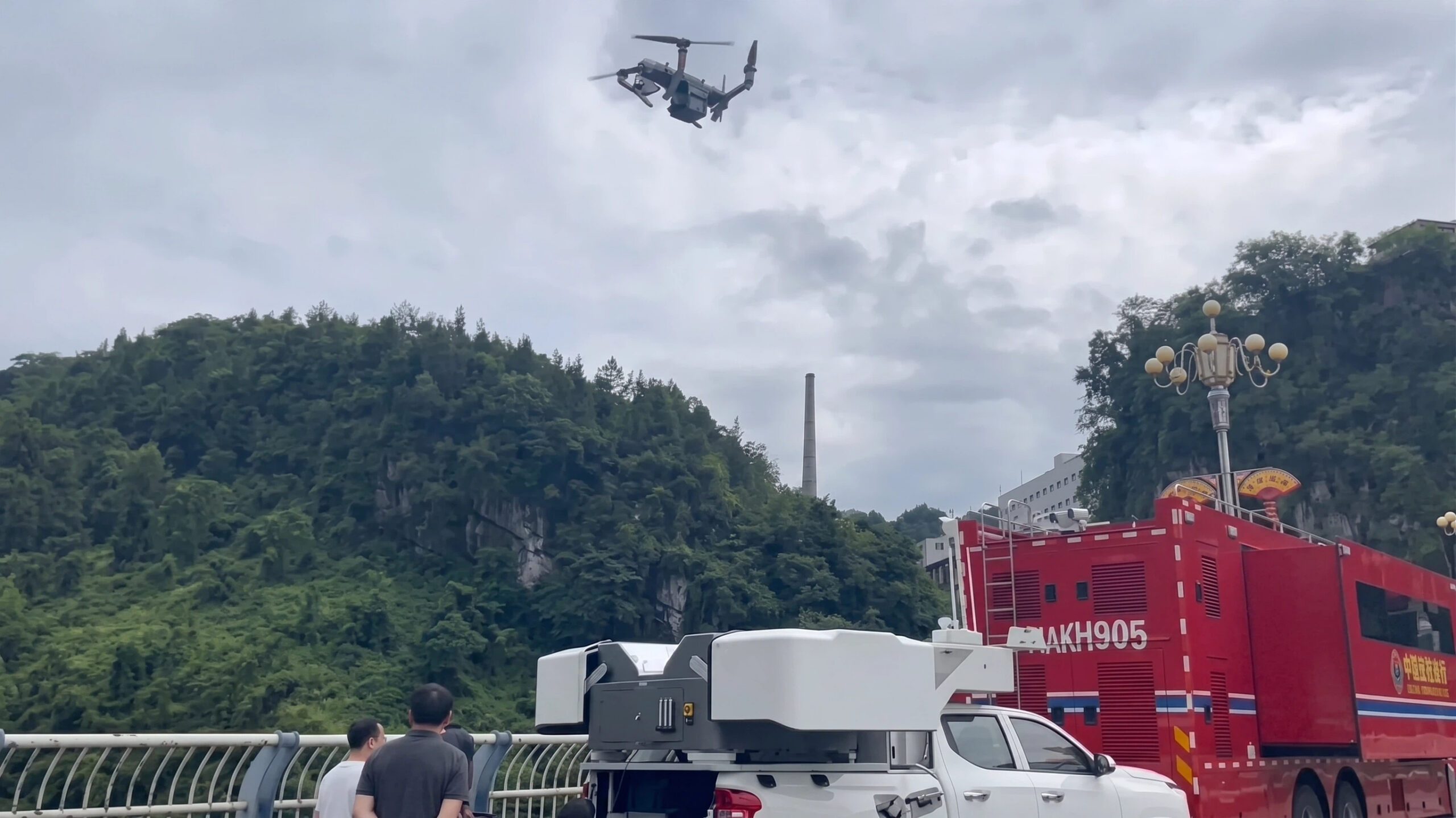
Using its JOS-P200 vehicle-mounted drone hangar, the company launched an autonomous aerial reconnaissance mission within minutes of arriving on site. In about one hour, responders received high-resolution aerial imagery and a detailed 3D model of the affected area. According to JOUAV, the data gave the command center an updated view of terrain conditions, landslide boundaries, and potential secondary hazards before committing personnel and equipment to the scene.

The deployment illustrates a growing role for drones in disaster response. When damaged roads, unstable ground, or dangerous conditions limit access, aerial mapping can provide critical information without placing responders at additional risk.

Helping Responders Decide Where to Go

At the center of the deployment was JOUAV’s JOS-P200 Real-Time 3D Mapping System. The platform combines a PH-10H multirotor UAV, remote sensing payloads, broadband communications, edge computing, and real-time modeling software.
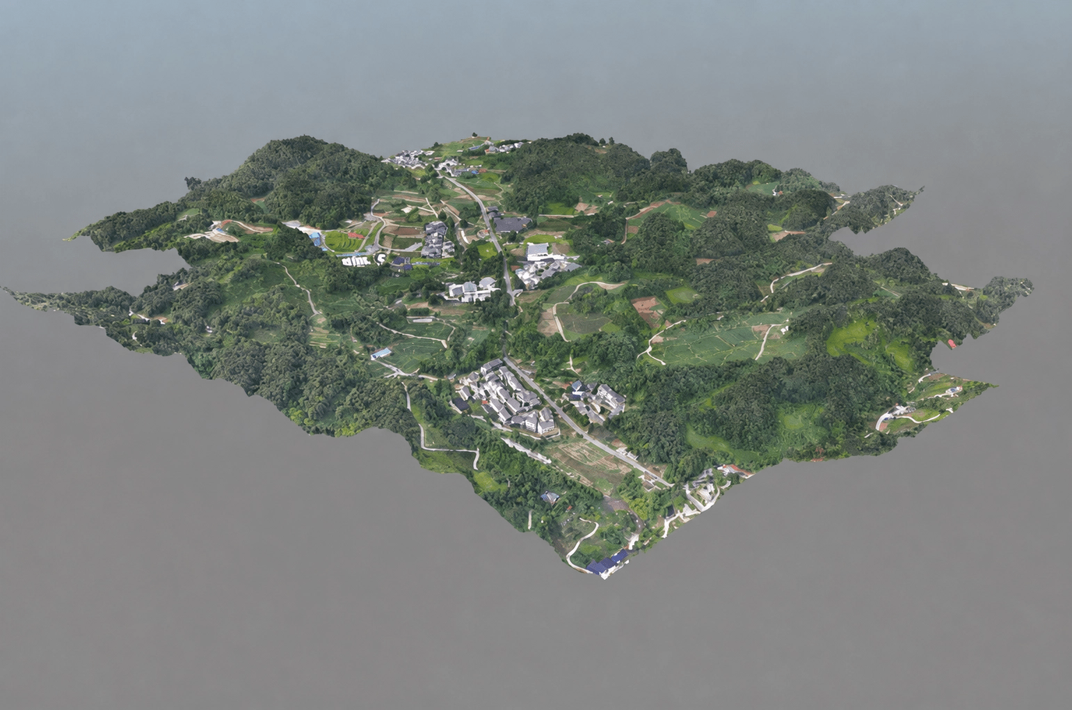
Unlike traditional mapping workflows, which often require processing after the aircraft lands, the system collects, transmits, processes, and models data at the same time. Orthomosaic maps, digital surface models, and textured 3D models become available while the drone remains in flight.

Unlike standard aerial video, a 3D model allows emergency managers to measure terrain, identify blocked routes, estimate the extent of the landslide, and better understand elevation changes that could affect rescue operations. That information can help incident commanders decide where to send crews and equipment first.

JOUAV says the system delivers spatial resolution of up to 10 centimeters and can model a one-square-kilometer disaster area in less than five minutes. The company says this reduces the time needed to produce the first operational map for emergency decision-making.

Beyond Live Video

Live video can show responders what a disaster scene looks like. A live 3D model provides additional context by allowing teams to measure distances, identify hazards, and mark locations while the aircraft continues collecting data.

According to JOUAV, the platform combines aerial imagery, live video, broadband communications, edge computing, and AI-assisted analysis into a single workflow. Emergency teams can identify roads, buildings, vehicles, forests, waterways, and other key features directly within the live 3D environment. They can also perform measurements, conduct spatial analysis, and add annotations without waiting for post-flight processing.

The company also says the platform can integrate field sensor data in real time, giving command personnel a more complete operational picture throughout the response.

Expanding Coverage for Larger Disasters

For larger incidents, JOUAV offers a similar real-time mapping solution built around its CW-15 VTOL UAV. The company says the aircraft supports long-range BVLOS operations across complex terrain while continuously transmitting mapping data to a mobile processing terminal for live scene reconstruction.

In a recent deployment, JOUAV reports that a CW-15 equipped with a five-camera oblique mapping payload generated a detailed 3D model covering 2.18 square kilometers about five minutes after data acquisition.

Fast disaster response depends on good information as much as it depends on personnel and equipment. As drone mapping systems continue to reduce the time needed to build accurate 3D models, emergency managers can begin planning rescue operations sooner and with a better understanding of the risks facing crews on the ground. While this deployment took place in China, the need for rapid situational awareness is shared by emergency response agencies around the world.

Read more:

  • FlyGuys and TerraFort Cut Disaster Damage Assessments from Months to Days
  • As Disaster Risks Grow, WingXpand and Verizon Explore New Tools for Emergency Response
  • TV Asahi and KDDI Smart Drone Partner for Disaster News Drone Deployment

Miriam McNabb

Miriam McNabb is the Editor-in-Chief of DRONELIFE and CEO of JobForDrones, a professional drone services marketplace, and a fascinated observer of the emerging drone industry and the regulatory environment for drones. Miriam has penned over 3,000 articles focused on the commercial drone space and is an international speaker and recognized figure in the industry.  Miriam has a degree from the University of Chicago and over 20 years of experience in high tech sales and marketing for new technologies.
For drone industry consulting or writing, Email Miriam.

TWITTER:@spaldingbarker

Subscribe to DroneLife here.

Filed Under: Applications, Asia, Disaster Response, Drone News, Drone News Feeds, Mapping, Mapping Technology, News Tagged With: 3d mapping, aerial mapping, BVLOS, disaster assessment, disaster response, drone emergency management, drone landslide response, emergency response drones, geospatial intelligence, JOUAV, Public Safety Drones, real time mapping, UAV mapping, vehicle-mounted drone hangar

Reader Interactions

Leave a Reply Cancel reply

Your email address will not be published. Required fields are marked *

Primary Sidebar

LATEST

U.S. Drone Manufacturing’s New Advantage Isn’t Just Factories. It’s Agility.

As demand accelerates, drone companies are scaling by building flexible engineering teams instead of trying to do everything in-house. The…

Continue Reading U.S. Drone Manufacturing’s New Advantage Isn’t Just Factories. It’s Agility.

DoorDash Is Building More Than a Drone Delivery Service

With its own aircraft, FAA air carrier certificate, and delivery platform, DoorDash is taking a vertically integrated approach that echoes…

Continue Reading DoorDash Is Building More Than a Drone Delivery Service

Drones vs. Bears? JUIDA Spotlights Six Solutions Across Japan

  This article published in collaboration with JUIDA, the Japan UAS Industrial Development Association.     The Bear Mitigation Technology Showcase…

Continue Reading Drones vs. Bears? JUIDA Spotlights Six Solutions Across Japan

Flytrex and Nash Partner to Route Drone and Courier Deliveries Across Dallas-Fort Worth

The autonomous-first, multi-modal integration is live at every Flytrex site in the Dallas-Fort Worth metro. Flytrex and Nash announced a…

Continue Reading Flytrex and Nash Partner to Route Drone and Courier Deliveries Across Dallas-Fort Worth

Designing a Heavy Lift Drone from the Ground Up: PyroDelta Energy on this Episode of the Drone Radio Show!

In this episode of the Drone Radio Show, Michael Abdelmaseh talks to host Randy Goers about the engineering behind PyroDelta’s…

Continue Reading Designing a Heavy Lift Drone from the Ground Up: PyroDelta Energy on this Episode of the Drone Radio Show!

Don’t Miss Mike Moulton on the Public Safety Drone Review, August 4

Join us Tuesday, August 4 at 3 p.m. ET for the next edition of the Public Safety Drone Review, presented…

Continue Reading Don’t Miss Mike Moulton on the Public Safety Drone Review, August 4

How the World Is Addressing Human Factors in Drone Operations

Part 2 of DRONELIFE’s Exclusive Series: The Human Edge: People, Perception, and the Future of Drone Operations As commercial drone…

Continue Reading How the World Is Addressing Human Factors in Drone Operations

FlyGuys and TerraFort Cut Disaster Damage Assessments from Months to Days

Integrated platform cuts damage assessment time from months to 10 days following Super Typhoon Sinlaku FlyGuys and disaster intelligence company…

Continue Reading FlyGuys and TerraFort Cut Disaster Damage Assessments from Months to Days

After 700 Drone Seizures, What Did the FIFA World Cup Really Prove?

The tournament suggests that layered counter-drone security can work. The next challenge may be preventing unnecessary incidents before they happen.…

Continue Reading After 700 Drone Seizures, What Did the FIFA World Cup Really Prove?

New FCC Language Reveals Next Phase of Trusted Drone Policy

Latest FCC notice suggests Conditional Approval is becoming a long-term compliance framework rather than a temporary exemption program The Federal…

Continue Reading New FCC Language Reveals Next Phase of Trusted Drone Policy

Secondary Sidebar

Footer

SPONSORED

Inspired Flight Gremsy IF800 VIO F1 drones geo week

What Will It Take to Strengthen U.S. Drone Manufacturing? A Conversation with Inspired Flight’s CEO

Global Mapper Mobile data collection

Collection Ground Control Points with Global Mapper Mobile

Military Drone Mapping Solutions

How SimActive’s Correlator3D™ is Revolutionizing Military Mapping: An Exclusive Interview with CEO Philippe Simard

Photogrammetry Accuracy Standards

SimActive Photogrammetry Software: Enabling Users to Meet Accuracy Standards for Over 20 Years

NACT Engineering Parrot ANAFI tether indoor shot

Smart Tether for Parrot ANAFI USA from NACT Engineering

Blue Marble, features global mapper, features Blue Marble

Check Out These New Features in Global Mapper v25 from Blue Marble

About Us | Contact Us | Advertise With Us | Write for Us | Privacy Policy | Terms of Service

The Trusted Source for the Business of Drones.

This website uses cookies and third party services. By clicking OK, you are agreeing to our privacy policy. ACCEPT

Manage consent

Privacy Overview

This website uses cookies to improve your experience while you navigate through the website. Out of these, the cookies that are categorized as necessary are stored on your browser as they are essential for the working of basic functionalities of the website. We also use third-party cookies that help us analyze and understand how you use this website. These cookies will be stored in your browser only with your consent. You also have the option to opt-out of these cookies. But opting out of some of these cookies may affect your browsing experience.
Necessary
Always Enabled
Necessary cookies are absolutely essential for the website to function properly. These cookies ensure basic functionalities and security features of the website, anonymously.
CookieDurationDescription
cookielawinfo-checkbox-analytics11 monthsThis cookie is set by GDPR Cookie Consent plugin. The cookie is used to store the user consent for the cookies in the category "Analytics".
cookielawinfo-checkbox-functional11 monthsThe cookie is set by GDPR cookie consent to record the user consent for the cookies in the category "Functional".
cookielawinfo-checkbox-necessary11 monthsThis cookie is set by GDPR Cookie Consent plugin. The cookies is used to store the user consent for the cookies in the category "Necessary".
cookielawinfo-checkbox-others11 monthsThis cookie is set by GDPR Cookie Consent plugin. The cookie is used to store the user consent for the cookies in the category "Other.
cookielawinfo-checkbox-performance11 monthsThis cookie is set by GDPR Cookie Consent plugin. The cookie is used to store the user consent for the cookies in the category "Performance".
viewed_cookie_policy11 monthsThe cookie is set by the GDPR Cookie Consent plugin and is used to store whether or not user has consented to the use of cookies. It does not store any personal data.
Functional
Functional cookies help to perform certain functionalities like sharing the content of the website on social media platforms, collect feedbacks, and other third-party features.
Performance
Performance cookies are used to understand and analyze the key performance indexes of the website which helps in delivering a better user experience for the visitors.
Analytics
Analytical cookies are used to understand how visitors interact with the website. These cookies help provide information on metrics the number of visitors, bounce rate, traffic source, etc.
Advertisement
Advertisement cookies are used to provide visitors with relevant ads and marketing campaigns. These cookies track visitors across websites and collect information to provide customized ads.
Others
Other uncategorized cookies are those that are being analyzed and have not been classified into a category as yet.
SAVE & ACCEPT




