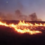
The Australian geospatial firm is using Correlator3D to generate orthomosaics from aerial imagery captured for wildfire prevention and land management projects. SimActive has announced that Landair Surveys is using its Correlator3D software to produce orthomosaics for planned burns mapping projects in Australia. The Montreal-based developer said the workflow is intended to … [Read more...] about Landair Surveys Uses SimActive Correlator3D for Planned Burns Mapping in Australia
Disaster Response
As Disaster Risks Grow, WingXpand and Verizon Explore New Tools for Emergency Response
WingXpand will work with Verizon Frontline and emergency teams to explore new tools for disaster assessment and community resilience As severe weather events continue to affect communities across the United States, drone and autonomous aircraft technologies are gaining attention as tools to support emergency response. This week, St. Louis-based WingXpand announced its … [Read more...] about As Disaster Risks Grow, WingXpand and Verizon Explore New Tools for Emergency Response
AirData UAV and LeoSight Bring Live Drone Data for DFR Programs
The new LeoSight AirData integration streams real-time flight data, telemetry, and operational insights from AirData directly into LeoCommand, giving dispatchers and field teams shared visibility across drone and DFR operations. LeoSight, a unified command software platform for public safety, has integrated with AirData UAV, one of the most widely deployed commercial drone … [Read more...] about AirData UAV and LeoSight Bring Live Drone Data for DFR Programs
Students Compete in XPRIZE Wildfire Finals With AI Drone Firefighting
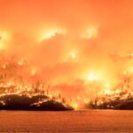
Silicon Valley students take on pros with wildfire drones. By Dronelife Features Editor Jim Magill The prestigious XPRIZE competition to find innovative solutions to battle the global threat of wildfires has attracted teams from all over the world, including teams of professional firefighters and first responders, teams representing drone and software industry … [Read more...] about Students Compete in XPRIZE Wildfire Finals With AI Drone Firefighting
Inside the Coachella Valley’s Plan to Centralize Drone First Responder Operations

By Dronelife Features Editor Jim Magill The Palm Springs, California Police Department is taking its Drones as First Responders (DFR) program to the next level, by jointly working with other cities and communities to integrate UAV dispatching operations into a region-wide system. Launched in December, the Coachella Valley Real-time Intelligence Center (CVRIC) pools the … [Read more...] about Inside the Coachella Valley’s Plan to Centralize Drone First Responder Operations


