• Skip to main content
  • Skip to secondary menu
  • Skip to primary sidebar
  • Skip to secondary sidebar
  • Skip to footer
  • DroneRacingLife
  • DroneFlyers
  • Newsletter
DroneLife

DRONELIFE

Stay up to date on all the latest Drone News

  • News
  • Products
  • Industries
    • Agriculture
    • Construction
    • Delivery
    • Dual Use
    • Inspection
    • Public Safety
    • Surveying
  • Enthusiasts
  • Regulations
  • Business
  • Video
  • Podcasts

Drone Mapping: Global Mapper Mobile New Features Mean Higher Accuracy Data Collection

July 27, 2022 by Miriam McNabb 7 Comments

Introducing Global Mapper Mobile’s New GNSS Device Support via TCP/IP Communication

Global Mapper Pro is a powerful geospatial data analysis program that contains tools for everything from raster image processing to photogrammetric point cloud creation with the Pixels to Points tool. Designed to work alongside Global Mapper Pro, the free iOS and Android Global Mapper Mobile app makes it easy for users to bring GIS data into the field for reference and GNSS data collection.

Continue reading below, or listen:

DroneLife · Global – Mapper – Mobiles – New – Features – Mean – More – Accurate – Drone – Data

Used for surveying, capturing images, and recording high-accuracy control points for drone-collected image processing, Global Mapper Mobile, with the subscription-based Pro Module, can be utilized in any industry.

Using the internal location services of the iOS or Android mobile device by default, users can capture images and create points, lines, and polygon features in Global Mapper Mobile. With the addition of the Global Mapper Mobile Pro Module, Advanced GPS functionality supports Bluetooth connection to external GNSS devices and RTK connection for higher accuracy data collection. The latest update to the mobile app, version 2.3, extends GNSS device support to the new Juniper Geode GNS3 and Garmin GLO GPS units and incorporates a new method for connection through TCP/IP communication.

 TCP/IP GNSS Device Communication

Before version 2.3 of the Global Mapper Mobile Pro Module, the Advanced GPS tools only supported connection to an external GNSS device via Bluetooth. Connecting to external devices via Bluetooth is reliable, but can require advanced permissions, which can be limiting in many situations. With a diverse market of available GNSS devices ready to be used by customers with Global Mapper Mobile, a new communication method was implemented, allowing GNSS device connection via TCP/IP communication.

The workflow to connect to a device using TCP/IP communication requires the IP configuration of the device through the Advanced GPS > IP Config option accessed through Global Mapper Mobile’s Main Menu. Here, information, including a name, hostname, and port, is specified for the new device, and the configuration is saved. Once set up, the GNSS device can be used in Global Mapper Mobile for more accurate GNSS-based positioning.

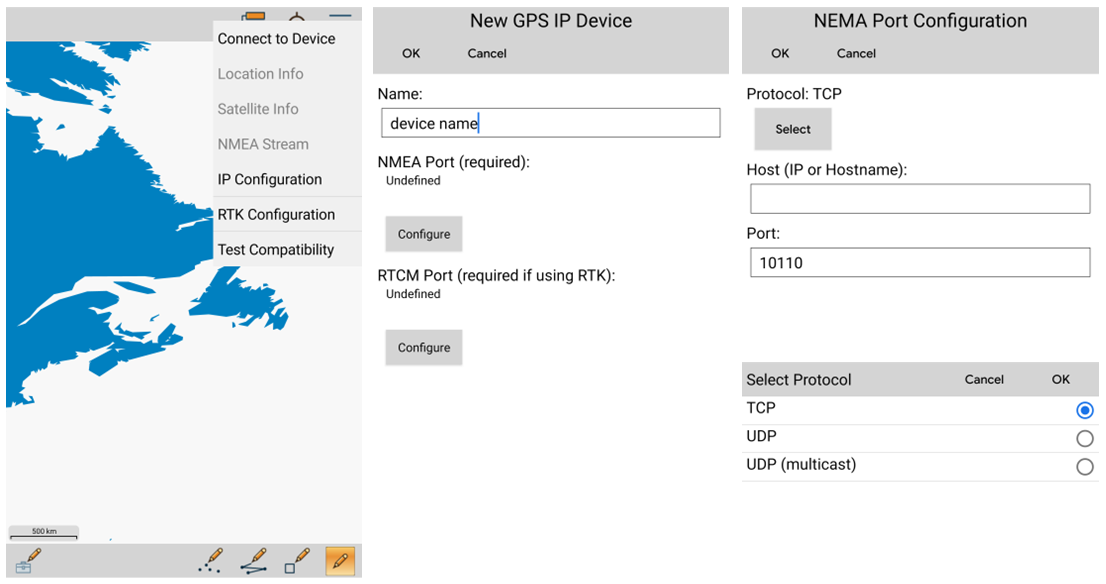
Accessed from the Main Menu > Advanced GPS tools, new GNSS devices can be connected to Global Mapper Mobile using TCP/IP communication.

While Global Mapper Mobile is available as a free download for both iOS and Android operating systems, the addition of the subscription-based Pro Module adds incredible value to the app through the suite of advanced tools. With external device Advanced GPS support for increased accuracy in data collection, additional online source availability, expanded projection support, and now, built-in analysis tools, Global Mapper Mobile with the Pro Module completes the Global Mapper set of geospatial data creation, collection, and analysis tools.

To test out Global Mapper Mobile, download the free app from the iOS App Store or Google Play Store today! Please contact us to purchase the Pro Module, or if you have any questions.


Miriam McNabb

Miriam McNabb is the Editor-in-Chief of DRONELIFE and CEO of JobForDrones, a professional drone services marketplace, and a fascinated observer of the emerging drone industry and the regulatory environment for drones. Miriam has penned over 3,000 articles focused on the commercial drone space and is an international speaker and recognized figure in the industry.  Miriam has a degree from the University of Chicago and over 20 years of experience in high tech sales and marketing for new technologies.
For drone industry consulting or writing, Email Miriam.

TWITTER:@spaldingbarker

Subscribe to DroneLife here.

Filed Under: Drone News, Drone News Feeds, News Tagged With: Blue Marble Graphics, drone mapping, Global Mapper Mobile, Global Mapper Mobile Pro

Reader Interactions

Trackbacks

  1. Drone Information of the Week July 29 DRONELIFE Headlines {Updated 2022} says:
    July 29, 2022 at 10:45 pm

    […] Drone Mapping: World Mapper Cellular New Options Imply Larger Accuracy Information Assortment […]

    Reply
  2. Drone Information of the Week July 29 DRONELIFE Headlines - Tech4SEO says:
    July 29, 2022 at 6:51 am

    […] Drone Mapping: World Mapper Cellular New Options Imply Greater Accuracy Information Assortment […]

    Reply
  3. Global Mapper Mobile New Features Drone Mapping says:
    July 28, 2022 at 8:34 am

    […] More… […]

    Reply
  4. Drone Mapping: Global Mapper Mobile New Features Mean Higher Accuracy Data Collection | taktik(z) GDI (Government Defense Infrastructure) says:
    July 27, 2022 at 11:31 pm

    […] post Drone Mapping: Global Mapper Mobile New Features Mean Higher Accuracy Data Collection appeared first on […]

    Reply
  5. World Mapper Cellular New Options Drone Mapping - Trend Directory says:
    July 27, 2022 at 6:51 pm

    […] Miriam McNabb is the Editor-in-Chief of DRONELIFE and CEO of JobForDrones, knowledgeable drone providers market, and a fascinated observer of the rising drone business and the regulatory surroundings for drones. Miriam has penned over 3,000 articles targeted on the industrial drone area and is a world speaker and acknowledged determine within the business.  Miriam has a level from the College of Chicago and over 20 years of expertise in excessive tech gross sales and advertising for brand spanking new applied sciences.For drone business consulting or writing, E mail Miriam. […]

    Reply
  6. Drone Mapping: Global Mapper Mobile New Features Mean Higher Accuracy Data Collection - UAV FL says:
    July 27, 2022 at 5:24 pm

    […] post Drone Mapping: Global Mapper Mobile New Features Mean Higher Accuracy Data Collection appeared first on […]

    Reply
  7. Global Mapper Mobile New Features Drone Mapping – Game Up News says:
    July 27, 2022 at 2:40 pm

    […] Source link […]

    Reply

Leave a Reply Cancel reply

Your email address will not be published. Required fields are marked *

Primary Sidebar

LATEST

Buffalo’s Natrion Rolls Out NDAA-Compliant Drone Battery Cells

The Buffalo-based battery materials company debuts NDAA-compliant pouch cells with up to 80% more energy density than standard Li-ion. Natrion…

Continue Reading Buffalo’s Natrion Rolls Out NDAA-Compliant Drone Battery Cells

ePropelled Launches Integrated Power System for Agricultural Drones

New propulsion platform targets growing precision agriculture UAV market As agricultural drone adoption continues to expand worldwide, ePropelled has introduced…

Continue Reading ePropelled Launches Integrated Power System for Agricultural Drones

FAA and DoD Are Building the Rules for Drones Operating Near Sensitive Airspace

FAA and DoD Explore How Drones, Counter-UAS Systems, and Airports Can Share Airspace XPONENTIAL panel highlights growing cooperation between civil…

Continue Reading FAA and DoD Are Building the Rules for Drones Operating Near Sensitive Airspace

Urban UAV Operations Need More than Drones

Cloud Century has implemented more than 200 drone docks in China, learning what urban drone operations require. In this guest…

Continue Reading Urban UAV Operations Need More than Drones

MatrixSpace Brings Portable Counter-Drone Radar to Lithuanian Exercise

The xTechCounter Strike winner deploys portable AI-powered radar to strengthen low-altitude airspace awareness for M-SHORAD units in Pabradė. MatrixSpace is…

Continue Reading MatrixSpace Brings Portable Counter-Drone Radar to Lithuanian Exercise

Industrial Policy and Wright’s Law: A New Perspective on Building the U.S. Drone Industry

At the AUVSI XPONENTIAL 2026 conference this week, Red Cat Holdings executive Brendan Stewart delivered one of the more historically…

Continue Reading Industrial Policy and Wright’s Law: A New Perspective on Building the U.S. Drone Industry

How DHS Is Helping World Cup Host Cities Get Counter-UAS Ready Before FIFA 2026

DHS lab equips World Cup cities with counter-drone guidance. By DRONELIFE Features Editor Jim Magill (Editor’s note: This is part…

Continue Reading How DHS Is Helping World Cup Host Cities Get Counter-UAS Ready Before FIFA 2026

Project ULTRA Aims to Normalize Drone Operations in Shared Airspace

FAA, DoD, and industry partners use Grand Forks test environment to develop scalable systems for UAS, logistics, and counter-UAS coordination…

Continue Reading Project ULTRA Aims to Normalize Drone Operations in Shared Airspace

Michigan’s Bet on the Low Altitude Economy: How M Air Connects Aerospace Innovation and Detroit Manufacturing

At XPONENTIAL 2026 this week, leaders from University of Michigan outlined an ambitious vision for the future of drones and…

Continue Reading Michigan’s Bet on the Low Altitude Economy: How M Air Connects Aerospace Innovation and Detroit Manufacturing

CVS, SkyfireAI, and Thales Outline Drone-Based Healthcare Response Network at XPONENTIAL 2026

Panel highlights healthcare logistics, emergency response, and disaster resilience as key drone use cases At the XPONENTIAL 2026 conference in…

Continue Reading CVS, SkyfireAI, and Thales Outline Drone-Based Healthcare Response Network at XPONENTIAL 2026

Secondary Sidebar

Footer

SPONSORED

Inspired Flight Gremsy IF800 VIO F1 drones geo week

What Will It Take to Strengthen U.S. Drone Manufacturing? A Conversation with Inspired Flight’s CEO

Global Mapper Mobile data collection

Collection Ground Control Points with Global Mapper Mobile

Military Drone Mapping Solutions

How SimActive’s Correlator3D™ is Revolutionizing Military Mapping: An Exclusive Interview with CEO Philippe Simard

Photogrammetry Accuracy Standards

SimActive Photogrammetry Software: Enabling Users to Meet Accuracy Standards for Over 20 Years

NACT Engineering Parrot ANAFI tether indoor shot

Smart Tether for Parrot ANAFI USA from NACT Engineering

Blue Marble, features global mapper, features Blue Marble

Check Out These New Features in Global Mapper v25 from Blue Marble

About Us | Contact Us | Advertise With Us | Write for Us | Privacy Policy | Terms of Service

The Trusted Source for the Business of Drones.

This website uses cookies and third party services. By clicking OK, you are agreeing to our privacy policy. ACCEPT

Manage consent

Privacy Overview

This website uses cookies to improve your experience while you navigate through the website. Out of these, the cookies that are categorized as necessary are stored on your browser as they are essential for the working of basic functionalities of the website. We also use third-party cookies that help us analyze and understand how you use this website. These cookies will be stored in your browser only with your consent. You also have the option to opt-out of these cookies. But opting out of some of these cookies may affect your browsing experience.
Necessary
Always Enabled
Necessary cookies are absolutely essential for the website to function properly. These cookies ensure basic functionalities and security features of the website, anonymously.
CookieDurationDescription
cookielawinfo-checkbox-analytics11 monthsThis cookie is set by GDPR Cookie Consent plugin. The cookie is used to store the user consent for the cookies in the category "Analytics".
cookielawinfo-checkbox-functional11 monthsThe cookie is set by GDPR cookie consent to record the user consent for the cookies in the category "Functional".
cookielawinfo-checkbox-necessary11 monthsThis cookie is set by GDPR Cookie Consent plugin. The cookies is used to store the user consent for the cookies in the category "Necessary".
cookielawinfo-checkbox-others11 monthsThis cookie is set by GDPR Cookie Consent plugin. The cookie is used to store the user consent for the cookies in the category "Other.
cookielawinfo-checkbox-performance11 monthsThis cookie is set by GDPR Cookie Consent plugin. The cookie is used to store the user consent for the cookies in the category "Performance".
viewed_cookie_policy11 monthsThe cookie is set by the GDPR Cookie Consent plugin and is used to store whether or not user has consented to the use of cookies. It does not store any personal data.
Functional
Functional cookies help to perform certain functionalities like sharing the content of the website on social media platforms, collect feedbacks, and other third-party features.
Performance
Performance cookies are used to understand and analyze the key performance indexes of the website which helps in delivering a better user experience for the visitors.
Analytics
Analytical cookies are used to understand how visitors interact with the website. These cookies help provide information on metrics the number of visitors, bounce rate, traffic source, etc.
Advertisement
Advertisement cookies are used to provide visitors with relevant ads and marketing campaigns. These cookies track visitors across websites and collect information to provide customized ads.
Others
Other uncategorized cookies are those that are being analyzed and have not been classified into a category as yet.
SAVE & ACCEPT