• Skip to main content
  • Skip to secondary menu
  • Skip to primary sidebar
  • Skip to secondary sidebar
  • Skip to footer
  • DroneRacingLife
  • DroneFlyers
  • Newsletter
DroneLife

DRONELIFE

Stay up to date on all the latest Drone News

  • News
  • Products
  • Industries
    • Agriculture
    • Construction
    • Delivery
    • Dual Use
    • Inspection
    • Public Safety
    • Surveying
  • Enthusiasts
  • Regulations
  • Business
  • Video
  • Podcasts

Making Sense of Big Drone Data with Optelos

August 23, 2018 by Sponsored Post 10 Comments

Commercial drone adoption is currently at an all-time high.  But we’re still far from where drones are fully integrated into the processes that make businesses grow.   Maybe we are not quite as the level of the pioneers of aviation like the Wright brothers were but let’s agree that we are early in the process.  As builders, growers, engineers, and the like continue to scale their drone operations the applications use increasing amount of data to make better decisions and a larger percentage of the total number of applications will use drones and the data that they can provide.   The amount of drone data collected is only going to rise as will the importance of the data that drones provide.

While it’s exciting to see companies gather more drone data, sometimes, additional information can be more of a burden than a benefit. How do you make sense of all this data and streamline the decision-making process?  No one wants to pour over large amounts of files manually looking for exceptions or to be able to identify those characteristics that allow user to be able to gauge progress, show volume, or find exceptions from a standard.

DroneLife reached out to CEO David Tran of Optelos on the importance of integrating with DroneDeploy.

“We are thrilled to be working with DroneDeploy and helping customers streamline the inspection and analysis of their drone data.  Our customers can seamlessly export their DroneDeploy results such as Orthomosaics, Point Clouds, and imagery directly into Optelos.  They can then use our powerful inspection and analytics tools to complete their deliverables to clients faster than ever before.  Customers want actionable answers, so our goal at Optelos is to work with our partners, like DroneDeploy, to create a streamlined workflow that transforms data into business decision-enabling insights as quickly as possible.”

So let’s dig down a little deeper,  the Optelos Drone Work Advisor™ app. app seamlessly transfers your collected and processed data from DroneDeploy straight into the Optelos’ Drone Work Advisor™ platform.

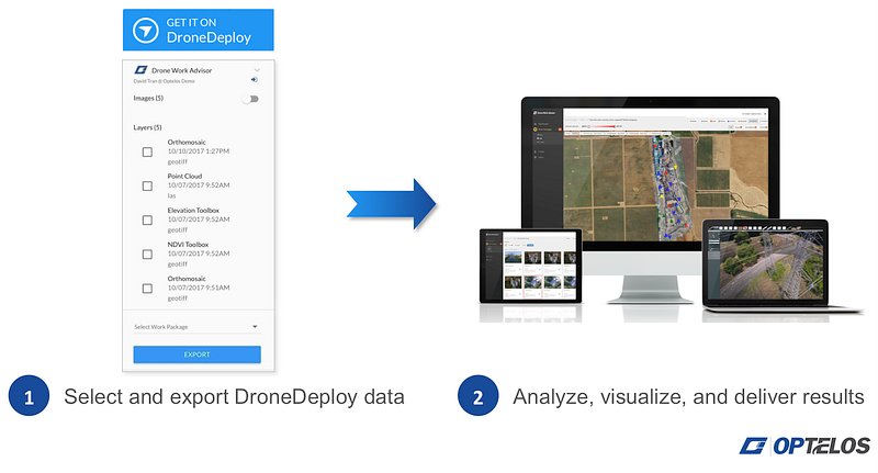
Optelos has a comprehensive suite of tools that link together images, videos, maps, 2D Orthomosaics, and 3D models in a simple dashboard.

Manage data with powerful analytics and results visualization

 You can also inspect, annotate and tag images, and view other media types including panoramas, PDFs, and Microsoft Word, PowerPoint, and Excel documents.

Optelos provides comprehensive support to view your data

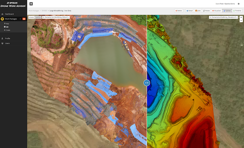
Compare Orthomosaics, Digital Elevation Models, and More Side by Side

As an example you can quickly overlay orthomosaics makes it simple to see site progress or compare maps to elevation models instantly.  Useful for applications in construction or mining.

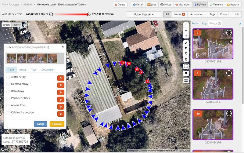
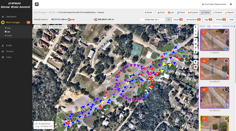
Assign Tasks, Highlight Issues and add Descriptions to Drone Imagery

As you work through your maps and photos, you can annotate the data to assign tasks, submit descriptions, and tag issues quickly — all of which is searchable using filters.  Allowing your team to work on the data more effectively where the data collection and analysis may very well be done by different people.

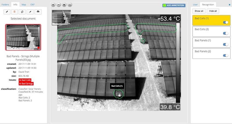
Automate Analysis with AI-Powered Insights built into the Optelos toolset

Optelos offers Enterprise customers the ability to automate image inspection.  By identifying and tagging known issues such as roof damage, broken solar cells, and more, it shortens the amount of time necessary to review data files. This eliminates time spent poring through images from visual inspections and tagging issues manually.  In many cases,  AI can identify those problems that a operator might miss freeing them up to do other things.

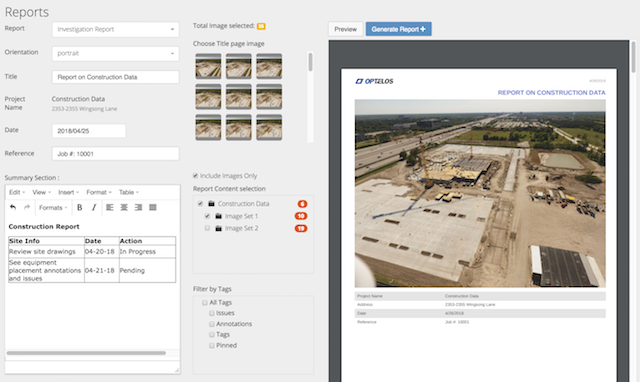
Share Data and Generate Customized Reports

Once data has been analyzed, it’s easy to share your insights with key stakeholders. You can either share folders directly or generate custom reports in PDF and HTML formats.

Want to start taking advantage of the combined power of DroneDeploy and Optelos? Add the Optelos Drone Work Advisor™ app to your DroneDeploy Dashboard to get started.

You can learn more at Optelos.  Much of this information was first published at DroneDeploy.  Learn more about some some cool new AI and Machine Learning features just announced by DroneDeploy.

Going to Interdrone?  You can learn how best to check these companies out at our guide at DroneLife guide to Interdrone.


Filed Under: Aerospace, Agriculture, Applications, Business and Finance, Chemical, Construction, Defense, Delivery, Education, Entertainment, Mining and Aggregates, Real Estate, Telecommunications, Uncategorized Tagged With: big data drones, drone mapping, DroneDeploy, Optelos

Reader Interactions

Trackbacks

  1. 8 Ways to Optimize Drone Asset Inspections – DRONELIFE – DroneLife – Inspection-Detection Pakistan says:
    December 12, 2021 at 5:15 pm

    […] too often something implemented after implementing a drone asset inspection program.  Start with a robust data management platform that will support collaboration, accommodate multiple data sources, and integrate with analysis […]

    Reply
  2. 8 Ways to Optimize Drone Asset Inspections - Droneoids says:
    July 27, 2021 at 5:01 pm

    […] too often something implemented after implementing a drone asset inspection program.  Start with a robust data management platform that will support collaboration, accommodate multiple data sources, and integrate with analysis […]

    Reply
  3. 8 Ways to Optimize Drone Asset Inspections - Best Drones Online says:
    July 27, 2021 at 3:57 pm

    […] too often something implemented after implementing a drone asset inspection program.  Start with a robust data management platform that will support collaboration, accommodate multiple data sources, and integrate with analysis […]

    Reply
  4. 8 Ways to Optimize Drone Asset Inspections: Optelos Puts Together Lessons Learned from Enterprise Clients - Summer Of Drones News says:
    July 27, 2021 at 12:33 pm

    […] one thing carried out after implementing a drone asset inspection program.  Start with a robust data management platform that may assist collaboration, accommodate a number of knowledge sources, and combine with […]

    Reply
  5. 8 Ways to Optimize Drone Asset Inspections - Secopter says:
    July 27, 2021 at 12:25 pm

    […] too often something implemented after implementing a drone asset inspection program.  Start with a robust data management platform that will support collaboration, accommodate multiple data sources, and integrate with analysis […]

    Reply
  6. 8 Ways to Optimize Drone Asset Inspections: Optelos Puts Together Lessons Learned from Enterprise Clients - The Drone Page says:
    July 27, 2021 at 12:05 pm

    […] too often something implemented after implementing a drone asset inspection program.  Start with a robust data management platform that will support collaboration, accommodate multiple data sources, and integrate with analysis […]

    Reply
  7. Optelos DSP Inspector Program Proves Partnerships are the Way to Get Customers and Thrive in the Drone Industry - The Digital Report says:
    March 7, 2021 at 2:51 pm

    […] an industry leading SaaS platform for Enterprises, offers a drone data management ecosystem that helps infrastructure companies digitize their inspections.  Frequently, however, […]

    Reply
  8. Optelos DSP Inspector Program Proves Partnerships are the Way to Get Customers and Thrive in the Drone Industry | Drone Films Limited says:
    March 2, 2021 at 8:24 am

    […] an industry leading SaaS platform for Enterprises, offers a drone data management ecosystem that helps infrastructure companies digitize their inspections.  Frequently, […]

    Reply
  9. Optelos DSP Inspector Program Proves Partnerships are the Way to Get Customers and Thrive in the Drone Industry - The Drone Page says:
    March 2, 2021 at 8:19 am

    […] an industry leading SaaS platform for Enterprises, offers a drone data management ecosystem that helps infrastructure companies digitize their inspections.  Frequently, however, […]

    Reply
  10. Making Sense of Big Drone Data with Optelos | News and Reviews about Drones, Quadcopter, Camera says:
    August 25, 2018 at 7:54 pm

    […] Source link […]

    Reply

Leave a Reply Cancel reply

Your email address will not be published. Required fields are marked *

Primary Sidebar

LATEST

European Defense Firms Partner on Sensor-to-Interceptor Counter-Drone Network

European companies combine detection, command-and-control, and interception technologies in layered air defense approach European counter-drone company Alpine Eagle and Latvian…

Continue Reading European Defense Firms Partner on Sensor-to-Interceptor Counter-Drone Network

From “Predictable Surprise” to Policy Priority: The Push for Faster Counter-Drone Deployment

As the planned attack on the White House highlights, drone threats are evolving faster than response capabilities. The reported disruption…

Continue Reading From “Predictable Surprise” to Policy Priority: The Push for Faster Counter-Drone Deployment

Japan Agriculture Drone Market Projected to Reach $357.8M by 2034

This article published in collaboration with JUIDA, the Japan UAS Industrial Development Association.   A new report from Tokyo-based Market Research…

Continue Reading Japan Agriculture Drone Market Projected to Reach $357.8M by 2034

WaiV Robotics Brings Autonomous Drone Recovery at Sea to U.S. Offshore Operators

As offshore energy assets move farther from shore, operators face growing challenges in inspection, maintenance, and emergency response. This week,…

Continue Reading WaiV Robotics Brings Autonomous Drone Recovery at Sea to U.S. Offshore Operators

Terra Drone Establishes Estonia-Based Defense Subsidiary to Support European Expansion

New company reflects broader shift from commercial drone services to defense and counter-drone systems Japan’s Terra Drone Corporation has established…

Continue Reading Terra Drone Establishes Estonia-Based Defense Subsidiary to Support European Expansion

NASA, UNOS and LifeNet Complete Successful BVLOS Drone Flights Carrying Human Kidneys

Study Examines Potential Role of Drones in Future Transplant Logistics All images, courtesy NASA. A new research collaboration between the…

Continue Reading NASA, UNOS and LifeNet Complete Successful BVLOS Drone Flights Carrying Human Kidneys

5 Federal Drone Policies Flying Under the Radar This Summer

From World Cup airspace restrictions to critical infrastructure rulemaking, several federal initiatives could shape the drone industry in the months…

Continue Reading 5 Federal Drone Policies Flying Under the Radar This Summer

Drone Industry Insights Launches the 9th Edition of the Global Drone Survey — The World’s Largest Annual Industry Survey for the Drone Market

Survey open to all actors in the global drone market ecosystem — manufacturers, operators, investors, associations, regulators, and service providers…

Continue Reading Drone Industry Insights Launches the 9th Edition of the Global Drone Survey — The World’s Largest Annual Industry Survey for the Drone Market

Proposed Patent Bill Could Have Major Implications for Drone Industry Intellectual Property

Prohibiting Adversarial Patents Act would make certain patents unenforceable while leaving ownership intact A newly introduced bill in Congress concerning…

Continue Reading Proposed Patent Bill Could Have Major Implications for Drone Industry Intellectual Property

Seattle Stadium “No-Drone Zone” During FIFA Matches

By Dronelife Features Editor Jim Magill Federal officials on Monday urged drone operators to stay away from Lumen Field, which…

Continue Reading Seattle Stadium “No-Drone Zone” During FIFA Matches

Secondary Sidebar

Footer

SPONSORED

Inspired Flight Gremsy IF800 VIO F1 drones geo week

What Will It Take to Strengthen U.S. Drone Manufacturing? A Conversation with Inspired Flight’s CEO

Global Mapper Mobile data collection

Collection Ground Control Points with Global Mapper Mobile

Military Drone Mapping Solutions

How SimActive’s Correlator3D™ is Revolutionizing Military Mapping: An Exclusive Interview with CEO Philippe Simard

Photogrammetry Accuracy Standards

SimActive Photogrammetry Software: Enabling Users to Meet Accuracy Standards for Over 20 Years

NACT Engineering Parrot ANAFI tether indoor shot

Smart Tether for Parrot ANAFI USA from NACT Engineering

Blue Marble, features global mapper, features Blue Marble

Check Out These New Features in Global Mapper v25 from Blue Marble

About Us | Contact Us | Advertise With Us | Write for Us | Privacy Policy | Terms of Service

The Trusted Source for the Business of Drones.

This website uses cookies and third party services. By clicking OK, you are agreeing to our privacy policy. ACCEPT

Manage consent

Privacy Overview

This website uses cookies to improve your experience while you navigate through the website. Out of these, the cookies that are categorized as necessary are stored on your browser as they are essential for the working of basic functionalities of the website. We also use third-party cookies that help us analyze and understand how you use this website. These cookies will be stored in your browser only with your consent. You also have the option to opt-out of these cookies. But opting out of some of these cookies may affect your browsing experience.
Necessary
Always Enabled
Necessary cookies are absolutely essential for the website to function properly. These cookies ensure basic functionalities and security features of the website, anonymously.
CookieDurationDescription
cookielawinfo-checkbox-analytics11 monthsThis cookie is set by GDPR Cookie Consent plugin. The cookie is used to store the user consent for the cookies in the category "Analytics".
cookielawinfo-checkbox-functional11 monthsThe cookie is set by GDPR cookie consent to record the user consent for the cookies in the category "Functional".
cookielawinfo-checkbox-necessary11 monthsThis cookie is set by GDPR Cookie Consent plugin. The cookies is used to store the user consent for the cookies in the category "Necessary".
cookielawinfo-checkbox-others11 monthsThis cookie is set by GDPR Cookie Consent plugin. The cookie is used to store the user consent for the cookies in the category "Other.
cookielawinfo-checkbox-performance11 monthsThis cookie is set by GDPR Cookie Consent plugin. The cookie is used to store the user consent for the cookies in the category "Performance".
viewed_cookie_policy11 monthsThe cookie is set by the GDPR Cookie Consent plugin and is used to store whether or not user has consented to the use of cookies. It does not store any personal data.
Functional
Functional cookies help to perform certain functionalities like sharing the content of the website on social media platforms, collect feedbacks, and other third-party features.
Performance
Performance cookies are used to understand and analyze the key performance indexes of the website which helps in delivering a better user experience for the visitors.
Analytics
Analytical cookies are used to understand how visitors interact with the website. These cookies help provide information on metrics the number of visitors, bounce rate, traffic source, etc.
Advertisement
Advertisement cookies are used to provide visitors with relevant ads and marketing campaigns. These cookies track visitors across websites and collect information to provide customized ads.
Others
Other uncategorized cookies are those that are being analyzed and have not been classified into a category as yet.
SAVE & ACCEPT