• Skip to main content
  • Skip to secondary menu
  • Skip to primary sidebar
  • Skip to secondary sidebar
  • Skip to footer
  • DroneRacingLife
  • DroneFlyers
  • Newsletter
DroneLife

DRONELIFE

Stay up to date on all the latest Drone News

  • News
  • Products
  • Industries
    • Agriculture
    • Construction
    • Delivery
    • Dual Use
    • Inspection
    • Public Safety
    • Surveying
  • Enthusiasts
  • Regulations
  • Business
  • Video
  • Podcasts

DJI Unveils DJI Modify: Intelligent 3D Model Editing Software for Seamless Integration with Enterprise Drones and Mapping Solutions

January 18, 2024 by Ian McNabb 6 Comments

DJI Modify: Drone Model EditingDJI Modify Enhances Workflow Efficiency in Surveying, Transportation, and Emergency Response with Interoperability and Smart Editing Capabilities

by DRONELIFE Staff Writer Ian J. McNab

DJI recently announced their new model editing software, DJI Modify, which is designed to integrate seamlessly with their range of enterprise drones and 3D 
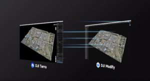
modelling and mapping software, DJI Terra. The combined solution is designed to serve the needs of a range of industries, including surveying, transportation, and emergency response. 

DJI touts the interoperability of their new solution, with Modify being designed to quickly and easily import and export complex files like ply, obj, and b3dm, enabling compatibility with both Terra and other software solutions. If combined with Terra, Modify can be launched using one click in any project, immediately creating Terra models for editing, including pre-identified objects and pre-processing of the model. This allows for easy repairs on common 3D model defects, streamlining workflows.

DJI Modify Drone Model Editing
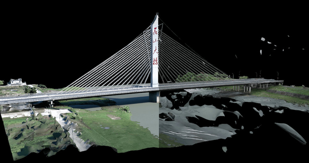
Modify’s intelligent auto-repair function supports flattening, editing textures, repairing water surfaces, removing floating parts, and filling holes. The smoother function displays both high and low-quality models and is capable of editing both via a single interface which can be previewed immediately. For customers seeking more control, the repair function can also be controlled manually by selecting custom polygons, areas, or meshes. 


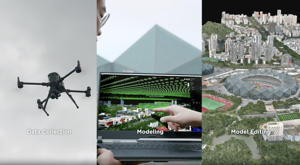
“Complex model processing work has been a challenge for the aerial survey industry for a long time. As DJI‘s first intelligent 3D model editing software, DJI Modify has completed the last piece of the puzzle in DJI’s entire enterprise solution from data collection, data processing, to model editing,” said Christina Zhang, Senior Director of Corporate Strategy at DJI. “We believe this will lead the editing of live 3D models to a more intelligent new realm, empowering surveyors, transportation operators, and first responders to improve their workflow.”

DJI Modify: Drone Model Editing

The official price of the DJI Modify software will be $1580. More information is available here. 

Read more:

  • DJI Delivery Drone Launched Globally: FlyCart 30
  • Baby, it’s Cold Outside: DJI Enterprise Publishes Winter Drone Guidelines
  • DJI Announces New Zenmuse L2 Drone LiDAR: From the Floor of Intergeo
  • The New DJI Mini 4: Here’s What the Reviewers are Saying (and Why)

Ian McNabb is a staff writer based in Boston, MA. His interests include geopolitics, emerging technologies, environmental sustainability, and Boston College sports.


Ian McNabb

Ian McNabb is a journalist focusing on drone technology and lifestyle content at Dronelife. He is based between Boston and NH and, when not writing, enjoys hiking and Boston area sports.

Filed Under: Data analytics, DJI, Drone News, Drone News Feeds, Drones in the News, Featured, News, Products Tagged With: 3D Model Editing, DJI Modify, dji terra, emergency response, enterprise drones, Interoperability, mapping software, Surveying Solutions, Transportation Industry, Workflow Efficiency

Reader Interactions

Trackbacks

  1. DJI Releases New FPV Drone: Avata 2 with Advanced Features – Techno News says:
    April 12, 2024 at 1:55 pm

    […] DJI Unveils DJI Modify: Intelligent 3D Model Editing Software for Seamless Integration with Enterpri… […]

    Reply
  2. DJI Modify: Drone Mannequin Enhancing - TC Technology News says:
    January 19, 2024 at 4:50 am

    […] Supply hyperlink […]

    Reply
  3. DJI Modify: Drone Mannequin Enhancing - Hello says:
    January 19, 2024 at 3:53 am

    […] Supply hyperlink […]

    Reply
  4. DJI Modify: Drone Mannequin Modifying - Enjbs says:
    January 18, 2024 at 5:44 pm

    […] Supply hyperlink […]

    Reply
  5. DJI Modify: Drone Model Modifying - Tech Gate says:
    January 18, 2024 at 3:35 pm

    […] Examine much more on google information […]

    Reply
  6. DJI Unveils DJI Modify: Intelligent 3D Model Editing Software for Seamless Integration with Enterprise Drones and Mapping Solutions – Independent Drone Exchange says:
    January 18, 2024 at 2:57 pm

    […] post DJI Unveils DJI Modify: Intelligent 3D Model Editing Software for Seamless Integration with Enterpri… appeared first on […]

    Reply

Leave a Reply Cancel reply

Your email address will not be published. Required fields are marked *

Primary Sidebar

LATEST

Buffalo’s Natrion Rolls Out NDAA-Compliant Drone Battery Cells

The Buffalo-based battery materials company debuts NDAA-compliant pouch cells with up to 80% more energy density than standard Li-ion. Natrion…

Continue Reading Buffalo’s Natrion Rolls Out NDAA-Compliant Drone Battery Cells

ePropelled Launches Integrated Power System for Agricultural Drones

New propulsion platform targets growing precision agriculture UAV market As agricultural drone adoption continues to expand worldwide, ePropelled has introduced…

Continue Reading ePropelled Launches Integrated Power System for Agricultural Drones

FAA and DoD Are Building the Rules for Drones Operating Near Sensitive Airspace

FAA and DoD Explore How Drones, Counter-UAS Systems, and Airports Can Share Airspace XPONENTIAL panel highlights growing cooperation between civil…

Continue Reading FAA and DoD Are Building the Rules for Drones Operating Near Sensitive Airspace

Urban UAV Operations Need More than Drones

Cloud Century has implemented more than 200 drone docks in China, learning what urban drone operations require. In this guest…

Continue Reading Urban UAV Operations Need More than Drones

MatrixSpace Brings Portable Counter-Drone Radar to Lithuanian Exercise

The xTechCounter Strike winner deploys portable AI-powered radar to strengthen low-altitude airspace awareness for M-SHORAD units in Pabradė. MatrixSpace is…

Continue Reading MatrixSpace Brings Portable Counter-Drone Radar to Lithuanian Exercise

Industrial Policy and Wright’s Law: A New Perspective on Building the U.S. Drone Industry

At the AUVSI XPONENTIAL 2026 conference this week, Red Cat Holdings executive Brendan Stewart delivered one of the more historically…

Continue Reading Industrial Policy and Wright’s Law: A New Perspective on Building the U.S. Drone Industry

How DHS Is Helping World Cup Host Cities Get Counter-UAS Ready Before FIFA 2026

DHS lab equips World Cup cities with counter-drone guidance. By DRONELIFE Features Editor Jim Magill (Editor’s note: This is part…

Continue Reading How DHS Is Helping World Cup Host Cities Get Counter-UAS Ready Before FIFA 2026

Project ULTRA Aims to Normalize Drone Operations in Shared Airspace

FAA, DoD, and industry partners use Grand Forks test environment to develop scalable systems for UAS, logistics, and counter-UAS coordination…

Continue Reading Project ULTRA Aims to Normalize Drone Operations in Shared Airspace

Michigan’s Bet on the Low Altitude Economy: How M Air Connects Aerospace Innovation and Detroit Manufacturing

At XPONENTIAL 2026 this week, leaders from University of Michigan outlined an ambitious vision for the future of drones and…

Continue Reading Michigan’s Bet on the Low Altitude Economy: How M Air Connects Aerospace Innovation and Detroit Manufacturing

CVS, SkyfireAI, and Thales Outline Drone-Based Healthcare Response Network at XPONENTIAL 2026

Panel highlights healthcare logistics, emergency response, and disaster resilience as key drone use cases At the XPONENTIAL 2026 conference in…

Continue Reading CVS, SkyfireAI, and Thales Outline Drone-Based Healthcare Response Network at XPONENTIAL 2026

Secondary Sidebar

Footer

SPONSORED

Inspired Flight Gremsy IF800 VIO F1 drones geo week

What Will It Take to Strengthen U.S. Drone Manufacturing? A Conversation with Inspired Flight’s CEO

Global Mapper Mobile data collection

Collection Ground Control Points with Global Mapper Mobile

Military Drone Mapping Solutions

How SimActive’s Correlator3D™ is Revolutionizing Military Mapping: An Exclusive Interview with CEO Philippe Simard

Photogrammetry Accuracy Standards

SimActive Photogrammetry Software: Enabling Users to Meet Accuracy Standards for Over 20 Years

NACT Engineering Parrot ANAFI tether indoor shot

Smart Tether for Parrot ANAFI USA from NACT Engineering

Blue Marble, features global mapper, features Blue Marble

Check Out These New Features in Global Mapper v25 from Blue Marble

About Us | Contact Us | Advertise With Us | Write for Us | Privacy Policy | Terms of Service

The Trusted Source for the Business of Drones.

This website uses cookies and third party services. By clicking OK, you are agreeing to our privacy policy. ACCEPT

Manage consent

Privacy Overview

This website uses cookies to improve your experience while you navigate through the website. Out of these, the cookies that are categorized as necessary are stored on your browser as they are essential for the working of basic functionalities of the website. We also use third-party cookies that help us analyze and understand how you use this website. These cookies will be stored in your browser only with your consent. You also have the option to opt-out of these cookies. But opting out of some of these cookies may affect your browsing experience.
Necessary
Always Enabled
Necessary cookies are absolutely essential for the website to function properly. These cookies ensure basic functionalities and security features of the website, anonymously.
CookieDurationDescription
cookielawinfo-checkbox-analytics11 monthsThis cookie is set by GDPR Cookie Consent plugin. The cookie is used to store the user consent for the cookies in the category "Analytics".
cookielawinfo-checkbox-functional11 monthsThe cookie is set by GDPR cookie consent to record the user consent for the cookies in the category "Functional".
cookielawinfo-checkbox-necessary11 monthsThis cookie is set by GDPR Cookie Consent plugin. The cookies is used to store the user consent for the cookies in the category "Necessary".
cookielawinfo-checkbox-others11 monthsThis cookie is set by GDPR Cookie Consent plugin. The cookie is used to store the user consent for the cookies in the category "Other.
cookielawinfo-checkbox-performance11 monthsThis cookie is set by GDPR Cookie Consent plugin. The cookie is used to store the user consent for the cookies in the category "Performance".
viewed_cookie_policy11 monthsThe cookie is set by the GDPR Cookie Consent plugin and is used to store whether or not user has consented to the use of cookies. It does not store any personal data.
Functional
Functional cookies help to perform certain functionalities like sharing the content of the website on social media platforms, collect feedbacks, and other third-party features.
Performance
Performance cookies are used to understand and analyze the key performance indexes of the website which helps in delivering a better user experience for the visitors.
Analytics
Analytical cookies are used to understand how visitors interact with the website. These cookies help provide information on metrics the number of visitors, bounce rate, traffic source, etc.
Advertisement
Advertisement cookies are used to provide visitors with relevant ads and marketing campaigns. These cookies track visitors across websites and collect information to provide customized ads.
Others
Other uncategorized cookies are those that are being analyzed and have not been classified into a category as yet.
SAVE & ACCEPT