

SimActive and Correlator3D™: A Closer Look
Drone mapping has transformed industries by making geospatial data more accessible. However, achieving high-quality results requires both the right tools and the right approach. DRONELIFE.com interviewed Eric Andelin, Senior Workflow Specialist at SimActive, to uncover actionable tips for drone operators. SimActive, a leader in photogrammetry solutions, offers Correlator3D™, a robust mapping software designed to convert drone data into accurate geospatial products.
In this interview, Andelin shares advice on overcoming challenges, optimizing workflows, and setting up drone mapping projects for success.
Can you give us a brief introduction to SimActive and your flagship mapping software? What sets SimActive’s mapping software apart from other solutions in the market?
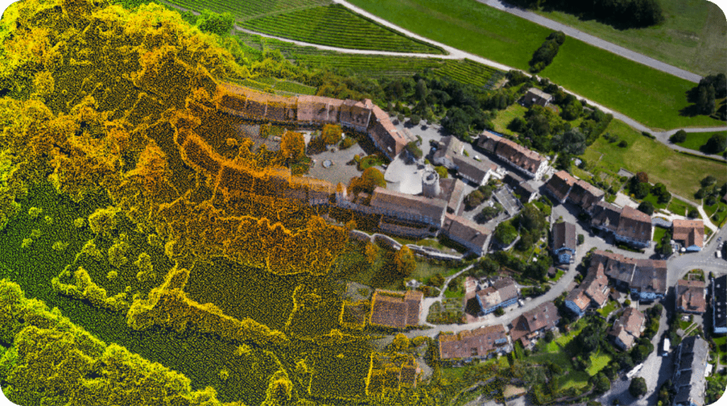
SimActive developed Correlator3D™, a photogrammetry software that generates geospatial data from satellite and aerial imagery, including drone-captured images. The software provides tools for aerial triangulation (AT), creating dense digital surface models (DSMs), digital terrain models (DTMs), orthomosaics, and even vectorized 3D features.
According to Andelin, Correlator3D™ offers a simple-to-follow interface that doesn’t require extensive retraining when expanding to other imaging platforms: “Regardless of acquisition platform, the processing steps are the same: as users’ business grows beyond drones, they do not have to reinvest time learning new processing steps.”
Additionally, SimActive maximizes processing speed by relying on GPUs instead of CPUs, enabling faster and more efficient workflows.
Addressing Common Challenges in Drone Mapping
What are the most common challenges drone operators face when mapping, and how does SimActive help address those?
While drones simplify image collection, many operators struggle with processing complexities. Andelin explained: “Without some understanding of photogrammetry, when drone mappers do not achieve the output results desired, they often do not understand why this is. This is a result of oversimplification, cloud, and one button processing solutions.”
SimActive helps operators overcome these challenges by allowing fine-tuning of workflows to produce outputs tailored to specific project requirements. This flexibility ensures users achieve the desired results without frustration.
Could you walk us through the process of using SimActive software to create accurate maps from drone data?
Correlator3D™ follows a modular workflow that progresses in a linear sequence. Projects begin with aerial triangulation, followed by surface model creation, orthorectification, and mosaic generation. Each module allows user customization, enabling operators to optimize outputs at every stage.
Best Practices for Drone Mapping
What are the top three tips you would give to drone operators aiming to get the best results when mapping?
Andelin emphasized three key strategies for success:
- Plan your flights carefully. Consider terrain, subject, flying height, overlap, and direction.
- Incorporate ground control. Results tied to ground control are more reliable than relying solely on RTK or PPK.
- Focus on actionable deliverables. While 3D models are engaging, maps often provide greater value to clients.
How important is flight planning when it comes to drone mapping, and what should operators keep in mind?
Flight planning is critical to mapping accuracy. Operators should evaluate the terrain and subject before setting their flight parameters. Andelin provided an example: “Consider a solar farm, the subject is very homogenous, like tree farms. This can trip up processing software if flown in a way where each consecutive image is basically the same.”
Flying higher or breaking projects into smaller areas can improve results. Environmental factors such as wind and sun angle should also be accounted for during planning.
Are there specific environmental conditions or drone settings that significantly affect mapping accuracy?
Wind and sun angle are two major factors to consider, said Andelin. While shadows might be useful in certain projects, they can complicate others. Operators should always align their settings with the intended output deliverables.
Data Processing and Ensuring Accuracy
How does SimActive handle the large volumes of data generated by drones during mapping missions?
SimActive designed Correlator3D™ to handle unlimited images. Projects can benefit from distributed processing, which allows operators to leverage multiple PCs and GPUs to manage extensive datasets efficiently.
What role does precision in data acquisition (altitude, overlap, etc.) play in the final mapping results, and how does your software ensure this accuracy?
Precision in data collection directly impacts map quality. Andelin highlighted the importance of on-site visits for tailoring flights to specific terrain and output needs. After aerial triangulation, SimActive generates an accuracy report: “An AT report with accuracy results including spatial accuracy and resolution are provided. The user can accept the results, or make adjustments and process another iteration if needed.”
How does your software support multispectral or LiDAR data processing for more advanced mapping applications?
SimActive allows multispectral and LiDAR data integration. LiDAR enhances mapping where photogrammetry cannot see the ground, while also enabling image alignment and ground control. The software even supports colorizing LiDAR point clouds, making them more versatile as standalone deliverables.
The Future of Drone Mapping
How do you see the future of drone mapping evolving, and what advancements in SimActive’s software can we expect in the near future?
The future of drone mapping is promising, with advancements in sensors and multi-sensor systems driving innovation. Andelin shared his optimism: “Considering there is a geospatial component to almost everything we as a society do, the future of mapping and drone mapping is very bright.”
Are there any emerging technologies or trends you believe will shape the future of drone mapping and geospatial data collection?
Andelin says that oblique sensors and multi-sensor systems are on the rise, driven by a desire for more information such as denser point clouds and 3D models.
Final Thoughts for Drone Operators
If you could give one final piece of advice to drone operators just starting out in mapping, what would it be?
Andelin offered thoughtful advice for operators new to drone mapping, emphasizing the importance of focus, proficiency, and quality work: “Focus on what your drone or drones are best suited for. Become proficient in the specific processing skill required using software such as Correlator3D locally, and build a good customer base on quality work. Outsourcing your processing to a cloud-based solution may not serve you well. Be local, be kind, and know that there are many other drone operators out there.”
By concentrating on their strengths, mastering essential processing skills, and prioritizing high-quality deliverables, new operators can establish themselves in a competitive industry. Embracing a local approach and fostering strong customer relationships can set a solid foundation for long-term success.
Want DRONELIFE news delivered to your inbox every weekday? Sign up here.
Read more:
- SimActive Software Enhances Construction Mapping for Bullseye Construction
- SimActive’s Correlator3D Used for Mapping in New Zealand’s Challenging Terrain
- How SimActive’s Correlator3D™ is Revolutionizing Military Mapping: An Exclusive Interview with CEO Philippe Simard

Miriam McNabb is the Editor-in-Chief of DRONELIFE and CEO of JobForDrones, a professional drone services marketplace, and a fascinated observer of the emerging drone industry and the regulatory environment for drones. Miriam has penned over 3,000 articles focused on the commercial drone space and is an international speaker and recognized figure in the industry. Miriam has a degree from the University of Chicago and over 20 years of experience in high tech sales and marketing for new technologies.
For drone industry consulting or writing, Email Miriam.
TWITTER:@spaldingbarker
Subscribe to DroneLife here.






Leave a Reply