• Skip to main content
  • Skip to secondary menu
  • Skip to primary sidebar
  • Skip to secondary sidebar
  • Skip to footer
  • DroneRacingLife
  • DroneFlyers
  • Newsletter
DroneLife

DRONELIFE

Stay up to date on all the latest Drone News

  • News
  • Products
  • Industries
    • Agriculture
    • Construction
    • Delivery
    • Dual Use
    • Inspection
    • Public Safety
    • Surveying
  • Enthusiasts
  • Regulations
  • Business
  • Video
  • Podcasts

SkyeBrowse Unveils Major Update for Faster 3D Modeling

July 10, 2024 by Miriam McNabb Leave a Comment

Enhanced Processing Speed and New GPS Feature Boost Accuracy for Construction, Surveying, and Public Safety

by DRONELIFE Staff Writer Ian J. McNab

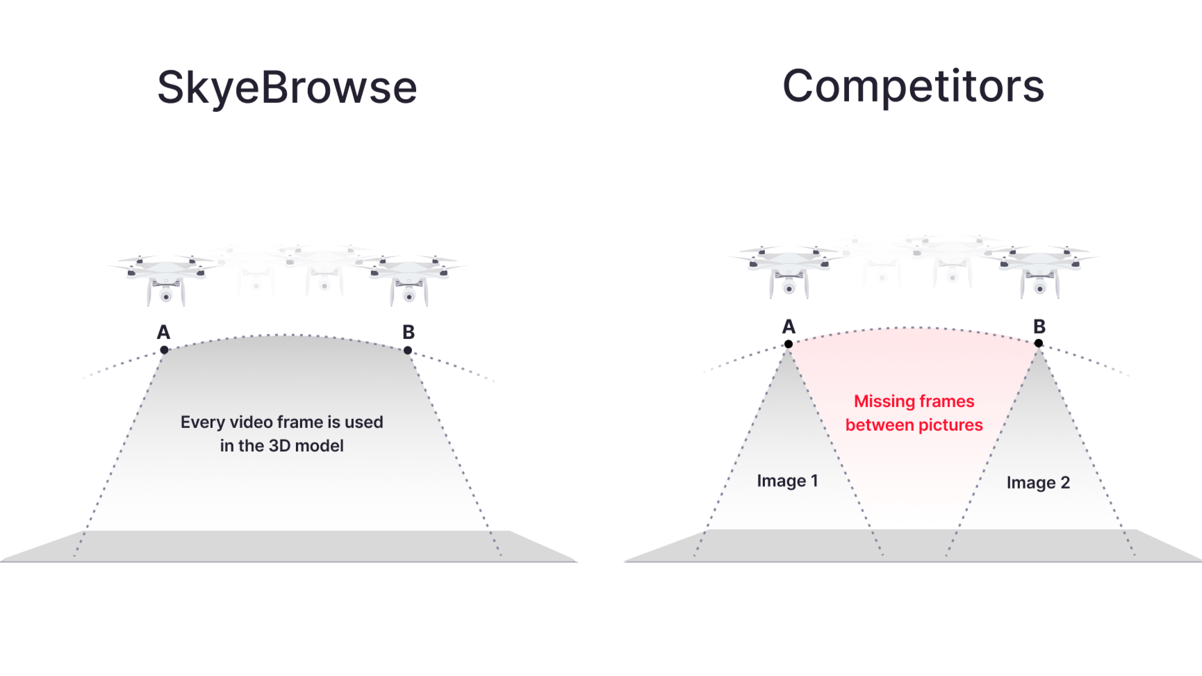
Telemetry software developer SkyeBrowse recently announced a major update to their flagship product, bringing them substantially closer to their stated goal of creating truly real-time 3D models using UAV assets. As part of these efforts, their processing speed has been increased 1.5x, allowing for significantly faster 3D modeling, and SkyeBrowse has added a new widely-requested GPS feature, allowing users to pinpoint specific locations. 

SkyeBrowse update


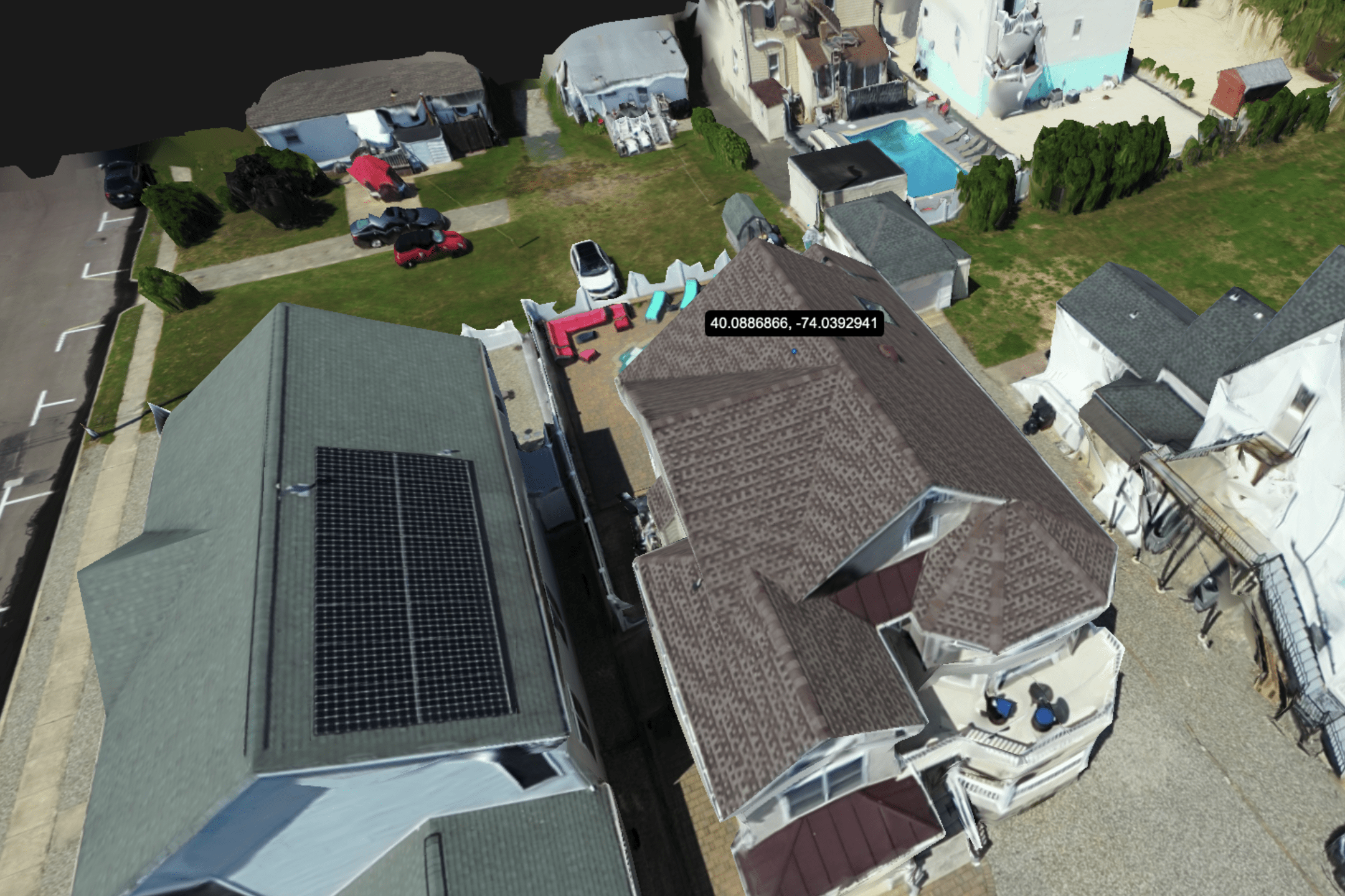
A simple point-and-click method allows for finding exact coordinates with a high degree of accuracy- as little as .25 inches of error for premium users (with Lite users getting 2 inches of error, and freemium users around 6-12 inches). Designed for clients in the construction, surveying, and public safety spaces, where accurate measurements are key, SkyeBrowse’s GPS system is perfect for looping in off-site analysts and giving them the detailed location data they need to do their jobs correctly. All location data can be shared using a simple link that can be accessed from any device, including phones, laptops, and traditional desktop computers. 

According to their press release, “Real-time 3D modeling is revolutionizing industries like public safety and emergency response. Imagine SWAT teams generating building interiors on entry, or firefighters mapping burning structures as they navigate. This technology enhances situational awareness and safety for first responders. In disaster response and urban planning, it enables immediate damage assessments, speeding up recovery efforts. For construction and real estate, it offers instant progress tracking and on-the-fly virtual tours. While real-time 3D modeling exists in laser scanners, they’re expensive, bulky, and require specialized training. They struggle in smoke-filled or reflective environments, limiting their use in dynamic situations. Our goal is to democratize this technology, making it accessible through smartphones and existing drone fleets. We’ve reduced processing times from hours to minutes, processing 100 times more data than traditional methods with our patented videogrammetry.”

More information on SkyeBrowse and their software solutions can be found here. 

Read more:

  • SkyeBrowse Wins DHS Grant for New Technology to Deal With School Shooters
  • Videogrammetry StartUp SkyeBrowse Raises $2.3 Million Seed Round – and Team Grows from 4 to 24


Miriam McNabb

Miriam McNabb is the Editor-in-Chief of DRONELIFE and CEO of JobForDrones, a professional drone services marketplace, and a fascinated observer of the emerging drone industry and the regulatory environment for drones. Miriam has penned over 3,000 articles focused on the commercial drone space and is an international speaker and recognized figure in the industry.  Miriam has a degree from the University of Chicago and over 20 years of experience in high tech sales and marketing for new technologies.
For drone industry consulting or writing, Email Miriam.

TWITTER:@spaldingbarker

Subscribe to DroneLife here.

Filed Under: Data analytics, Drone News, Drone News Feeds, News, Products Tagged With: construction technology, drone 3D modeling, GPS accuracy, public safety software, real time mapping, real-time 3D modeling, SkyeBrowse update, surveying tools, UAV 3D models, videogrammetry

Reader Interactions

Leave a Reply Cancel reply

Your email address will not be published. Required fields are marked *

Primary Sidebar

LATEST

Aeronext Unveils ActiveWing Logistics Drone Prototype for Long-Range Delivery

This article published in collaboration with JUIDA, the Japan UAS Industrial Development Association.     The Tokyo company’s new multicopter pairs…

Continue Reading Aeronext Unveils ActiveWing Logistics Drone Prototype for Long-Range Delivery

FBI, Atlanta PD Stress Need for ‘No-Drone Zone’ Compliance

By Dronelife Features Editor Jim Magill (Editor’s note: This story is part of a series of reports on efforts to…

Continue Reading FBI, Atlanta PD Stress Need for ‘No-Drone Zone’ Compliance

Building a Resilient Supply Chain: Regional Security Leaders Focus on Industrial Readiness

Northeast National Security Conference examines how the U.S. can strengthen its defense industrial base Supply chain security has become a…

Continue Reading Building a Resilient Supply Chain: Regional Security Leaders Focus on Industrial Readiness

Defense Leaders Call for Faster Paths from Innovation to the Field

Remarks at the Northeast National Security Conference highlight growing demand for rapid, commercially informed defense solutions The 2026 Northeast National…

Continue Reading Defense Leaders Call for Faster Paths from Innovation to the Field

Collective Defence Acquires Asterion in $1 Billion Deal Combining Cybersecurity and Counter-Drone Technology

Transaction creates Luxembourg’s first defense unicorn and brings together cyber defense and combat-tested counter-UAS capabilitie Collective Defence has announced its…

Continue Reading Collective Defence Acquires Asterion in $1 Billion Deal Combining Cybersecurity and Counter-Drone Technology

Vantis BVLOS System Adds New Partner, FAA Waiver Across 5,000 Square Miles

A new FAA aircraft-agnostic waiver lets Frontier Precision fly any NDAA-compliant drone under 55 pounds across more than 5,000 square…

Continue Reading Vantis BVLOS System Adds New Partner, FAA Waiver Across 5,000 Square Miles

MatrixSpace Validated in U.S. Army’s Operation Jailbreak Integration Sprint

The portable radar maker’s integration with Anduril Lattice and IBCS-M passed Army validation at Fort Carson, joining 55 companies in…

Continue Reading MatrixSpace Validated in U.S. Army’s Operation Jailbreak Integration Sprint

Army Medical Brigade Expands Drone Use for Battlefield Resupply

New training program helps medical personnel deliver critical supplies faster while reducing risk to soldiers The U.S. Army’s 44th Medical…

Continue Reading Army Medical Brigade Expands Drone Use for Battlefield Resupply

Counter-Drone Partnership Sends Ouster Shares Higher as Investors Focus on Airspace Security

Lidar company’s agreement with German counter-UAS firm highlights growing market for drone detection and interception technologies Shares of lidar manufacturer…

Continue Reading Counter-Drone Partnership Sends Ouster Shares Higher as Investors Focus on Airspace Security

Airport Drone Closures Raise a Bigger Question: What Do Authorities Actually Know?

Recent airport disruptions highlight a growing challenge: detecting an object in protected airspace is often easier than identifying it, locating…

Continue Reading Airport Drone Closures Raise a Bigger Question: What Do Authorities Actually Know?

Secondary Sidebar

Footer

SPONSORED

Inspired Flight Gremsy IF800 VIO F1 drones geo week

What Will It Take to Strengthen U.S. Drone Manufacturing? A Conversation with Inspired Flight’s CEO

Global Mapper Mobile data collection

Collection Ground Control Points with Global Mapper Mobile

Military Drone Mapping Solutions

How SimActive’s Correlator3D™ is Revolutionizing Military Mapping: An Exclusive Interview with CEO Philippe Simard

Photogrammetry Accuracy Standards

SimActive Photogrammetry Software: Enabling Users to Meet Accuracy Standards for Over 20 Years

NACT Engineering Parrot ANAFI tether indoor shot

Smart Tether for Parrot ANAFI USA from NACT Engineering

Blue Marble, features global mapper, features Blue Marble

Check Out These New Features in Global Mapper v25 from Blue Marble

About Us | Contact Us | Advertise With Us | Write for Us | Privacy Policy | Terms of Service

The Trusted Source for the Business of Drones.

This website uses cookies and third party services. By clicking OK, you are agreeing to our privacy policy. ACCEPT

Manage consent

Privacy Overview

This website uses cookies to improve your experience while you navigate through the website. Out of these, the cookies that are categorized as necessary are stored on your browser as they are essential for the working of basic functionalities of the website. We also use third-party cookies that help us analyze and understand how you use this website. These cookies will be stored in your browser only with your consent. You also have the option to opt-out of these cookies. But opting out of some of these cookies may affect your browsing experience.
Necessary
Always Enabled
Necessary cookies are absolutely essential for the website to function properly. These cookies ensure basic functionalities and security features of the website, anonymously.
CookieDurationDescription
cookielawinfo-checkbox-analytics11 monthsThis cookie is set by GDPR Cookie Consent plugin. The cookie is used to store the user consent for the cookies in the category "Analytics".
cookielawinfo-checkbox-functional11 monthsThe cookie is set by GDPR cookie consent to record the user consent for the cookies in the category "Functional".
cookielawinfo-checkbox-necessary11 monthsThis cookie is set by GDPR Cookie Consent plugin. The cookies is used to store the user consent for the cookies in the category "Necessary".
cookielawinfo-checkbox-others11 monthsThis cookie is set by GDPR Cookie Consent plugin. The cookie is used to store the user consent for the cookies in the category "Other.
cookielawinfo-checkbox-performance11 monthsThis cookie is set by GDPR Cookie Consent plugin. The cookie is used to store the user consent for the cookies in the category "Performance".
viewed_cookie_policy11 monthsThe cookie is set by the GDPR Cookie Consent plugin and is used to store whether or not user has consented to the use of cookies. It does not store any personal data.
Functional
Functional cookies help to perform certain functionalities like sharing the content of the website on social media platforms, collect feedbacks, and other third-party features.
Performance
Performance cookies are used to understand and analyze the key performance indexes of the website which helps in delivering a better user experience for the visitors.
Analytics
Analytical cookies are used to understand how visitors interact with the website. These cookies help provide information on metrics the number of visitors, bounce rate, traffic source, etc.
Advertisement
Advertisement cookies are used to provide visitors with relevant ads and marketing campaigns. These cookies track visitors across websites and collect information to provide customized ads.
Others
Other uncategorized cookies are those that are being analyzed and have not been classified into a category as yet.
SAVE & ACCEPT