• Skip to main content
  • Skip to secondary menu
  • Skip to primary sidebar
  • Skip to secondary sidebar
  • Skip to footer
  • DroneRacingLife
  • DroneFlyers
  • Newsletter
DroneLife

DRONELIFE

Stay up to date on all the latest Drone News

  • News
  • Products
  • Industries
    • Agriculture
    • Construction
    • Delivery
    • Dual Use
    • Inspection
    • Public Safety
    • Surveying
  • Enthusiasts
  • Regulations
  • Business
  • Video
  • Podcasts

Drone-Based LiDAR for Explosive Ordnance Disposal Units: More than Mapping

October 6, 2021 by Miriam McNabb 7 Comments

drone-based LiDARDrone-based LiDAR systems are being used by Explosive Ordnance Disposal (EOD) technicians for 3D mapping, in a successful transfer of technology from DoD laboratories to the field.

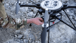
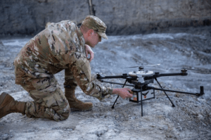
“RedTail LiDAR Systems, a leader in microelectromechanical systems (MEMS) mirror-based light detection and ranging (LiDAR) technology, has delivered six LiDAR systems to the 707th Ordnance Company stationed at Joint Base Lewis-McChord,” says a press release.  The deployment will allow the EOD techs to explore how drone-based LiDAR systems can be used to meet their goals.

The testing is focused on using LiDAR to map terrain.  LiDAR produces 3D maps, referred to as point clouds, that allow users to view mapped areas from any perspective, traveling around the models in 3D space using rotation and zoom capabilities in the viewer software.  This functionality will enable the EOD technicians to use the  RedTail LiDAR Systems RTL-450, integrated onto the Teledyne FLIR SkyRaider Unmanned Aerial System (UAS), to perform a broad range of functions: calculating crater volumes from improvised explosive device (IED) blasts, planning routes for unmanned ground vehicles, mission planning, and  surveillance.

MEMS Drone-Based LiDAR for Denser Point Clouds

drone-based LiDARThe  LiDAR technology  in the RTL-450 was developed in the Army Research Laboratory (ARL).  “The MEMS mirror-based design provides enhanced 3D imagery due to the fact that the laser pulses are steered to the ground in a very well-defined and controlled scan pattern,” says the press release.  The high density of the point clouds makes the technology ideal for use with AI and Machine Learning  algorithms, which allow automated target detection and classification.

The system can operate in either a raster scan mode for surveillance missions or a side-to-side line scan mode for area mapping while the UAS is flying.  The intuitive command and control, high-brightness display integrated into the ground control station (GCS), and real time 3D map generation allows operators to begin mission planning and analysis even before the mapping or surveillance missions are completed.

“Delivering these six LiDAR systems to EOD technicians for test and evaluation is a significant step forward in using MEMS mirror-based LiDAR technology to address a broad range of Department of Defense 3D mapping needs.  In addition, this delivery represents a true success story in transitioning a technology out of a Department of Defense laboratory and back into the hands of military operators,” said Brad DeRoos, President and CEO of RedTail LiDAR Systems.

To read more about drone-based LiDAR technology, read these previous articles on coaxial drones equipped with LiDAR, micro LiDAR sensors, the differences between LiDAR and photogrammetry, and how LiDAR is used in commercial drone applications.


Miriam McNabb

Miriam McNabb is the Editor-in-Chief of DRONELIFE and CEO of JobForDrones, a professional drone services marketplace, and a fascinated observer of the emerging drone industry and the regulatory environment for drones. Miriam has penned over 3,000 articles focused on the commercial drone space and is an international speaker and recognized figure in the industry.  Miriam has a degree from the University of Chicago and over 20 years of experience in high tech sales and marketing for new technologies.
For drone industry consulting or writing, Email Miriam.

TWITTER:@spaldingbarker

Subscribe to DroneLife here.

Filed Under: Drone News Feeds, Featured, News, Products, Sensors, Thermal imaging Tagged With: bomb disposal, LiDAR mapping, LiDAR sensors, RedTail LiDAR, Teledyne FLIR

Reader Interactions

Trackbacks

  1. Drone-Based LiDAR for Explosive Ordnance Disposal Units – DRONELIFE – DroneLife – Inspection-Detection Pakistan says:
    December 18, 2021 at 10:55 am

    […] source […]

    Reply
  2. Drone-Based LiDAR for Explosive Ordnance Disposal Units – Dronestagram Blog says:
    October 7, 2021 at 1:13 am

    […] More… […]

    Reply
  3. Drone-Based LiDAR for Explosive Ordnance Disposal Units: More than Mapping | taktik(z) GDI (Government Defense Infrastructure) says:
    October 6, 2021 at 7:21 pm

    […] DroneLife source|articles […]

    Reply
  4. Drone-Based LiDAR for Explosive Ordnance Disposal Units – Game Up News says:
    October 6, 2021 at 6:32 pm

    […] Source link […]

    Reply
  5. Drone-Based LiDAR for Explosive Ordnance Disposal Units - DRONELIFE - DroneLife - K드론팀 says:
    October 6, 2021 at 2:01 pm

    […] Drone-Based LiDAR for Explosive Ordnance Disposal Units – DRONELIFE  DroneLife […]

    Reply
  6. Drone-Based LiDAR for Explosive Ordnance Disposal Units: More than Mapping – DronePilots.News says:
    October 6, 2021 at 11:23 am

    […] post Drone-Based LiDAR for Explosive Ordnance Disposal Units: More than Mapping appeared first on […]

    Reply
  7. Drone-Based LiDAR for Explosive Ordnance Disposal Units: More than Mapping | Drone Films Limited says:
    October 6, 2021 at 11:16 am

    […] post Drone-Based LiDAR for Explosive Ordnance Disposal Units: More than Mapping appeared first on […]

    Reply

Leave a Reply Cancel reply

Your email address will not be published. Required fields are marked *

Primary Sidebar

LATEST

UK Firm Unveils New High Speed Drone Interceptor

Drone Defence, a UK-based technology firm, has introduced AeroStrike, a high-speed drone interceptor designed to physically counter hostile or unauthorized unmanned…

Continue Reading UK Firm Unveils New High Speed Drone Interceptor

FAA and FBI Establish Comprehensive Drone Restrictions for Super Bowl LX

The Federal Aviation Administration (FAA), in coordination with the Federal Bureau of Investigation (FBI), has established extensive drone restrictions for…

Continue Reading FAA and FBI Establish Comprehensive Drone Restrictions for Super Bowl LX

Draganfly FPV Drones Selected for U.S. Air Force Special Operations Training

Draganfly Inc. has been awarded a contract to supply Flex FPV drones and comprehensive training to U.S. Air Force Special…

Continue Reading Draganfly FPV Drones Selected for U.S. Air Force Special Operations Training

The Companies and Technologies Capturing the Counter-Drone Funding Surge

Governments around the world are no longer debating whether counter-drone systems are necessary. They are deciding which technologies, architectures, and…

Continue Reading The Companies and Technologies Capturing the Counter-Drone Funding Surge

February Public Safety Drone Review: Gemma Alcock of SkyBound Joins the Conversation

Register here to join the live broadcast on Tuesday, February 3 at 3 p.m. EST. The next edition of the…

Continue Reading February Public Safety Drone Review: Gemma Alcock of SkyBound Joins the Conversation

News Media Coalition Letter Challenges FAA’s Expansive NOTAM

By Dronelife Features Editor Jim Magill A coalition of news media associations has sent a letter to the FAA, raising…

Continue Reading News Media Coalition Letter Challenges FAA’s Expansive NOTAM

Ondas Unveils Integrated C-UAS System at Singapore Airshow

Ondas Holdings Inc. (Nasdaq: ONDS) has launched its unified Defence and Security portfolio at the Singapore Airshow 2026, featuring an…

Continue Reading Ondas Unveils Integrated C-UAS System at Singapore Airshow

UAVOS Tests Stratospheric Drone Payload for Earth Observation

UAVOS has announced successful flight testing of an advanced optoelectronic payload system integrated aboard the ApusNeo 18, a solar-powered high-altitude…

Continue Reading UAVOS Tests Stratospheric Drone Payload for Earth Observation

The Drone Industry’s Next Bottleneck Isn’t the Aircraft

Why Networks, Chips, and Trusted Infrastructure Will Decide Who Scales (News and commentary.) Commercial drones are increasingly shaped by forces…

Continue Reading The Drone Industry’s Next Bottleneck Isn’t the Aircraft

UK MOD Selects Seven Partners for Project NYX Apache Wingman Drone Project

The UK Ministry of Defence has invited seven industry partners to advance designs for autonomous drones designed to operate alongside…

Continue Reading UK MOD Selects Seven Partners for Project NYX Apache Wingman Drone Project

Secondary Sidebar

Footer

SPONSORED

Inspired Flight Gremsy IF800 VIO F1 drones geo week

What Will It Take to Strengthen U.S. Drone Manufacturing? A Conversation with Inspired Flight’s CEO

Global Mapper Mobile data collection

Collection Ground Control Points with Global Mapper Mobile

Military Drone Mapping Solutions

How SimActive’s Correlator3D™ is Revolutionizing Military Mapping: An Exclusive Interview with CEO Philippe Simard

Photogrammetry Accuracy Standards

SimActive Photogrammetry Software: Enabling Users to Meet Accuracy Standards for Over 20 Years

NACT Engineering Parrot ANAFI tether indoor shot

Smart Tether for Parrot ANAFI USA from NACT Engineering

Blue Marble, features global mapper, features Blue Marble

Check Out These New Features in Global Mapper v25 from Blue Marble

About Us | Contact Us | Advertise With Us | Write for Us | Privacy Policy | Terms of Service

The Trusted Source for the Business of Drones.

This website uses cookies and third party services. By clicking OK, you are agreeing to our privacy policy. ACCEPT

Manage consent

Privacy Overview

This website uses cookies to improve your experience while you navigate through the website. Out of these, the cookies that are categorized as necessary are stored on your browser as they are essential for the working of basic functionalities of the website. We also use third-party cookies that help us analyze and understand how you use this website. These cookies will be stored in your browser only with your consent. You also have the option to opt-out of these cookies. But opting out of some of these cookies may affect your browsing experience.
Necessary
Always Enabled
Necessary cookies are absolutely essential for the website to function properly. These cookies ensure basic functionalities and security features of the website, anonymously.
CookieDurationDescription
cookielawinfo-checkbox-analytics11 monthsThis cookie is set by GDPR Cookie Consent plugin. The cookie is used to store the user consent for the cookies in the category "Analytics".
cookielawinfo-checkbox-functional11 monthsThe cookie is set by GDPR cookie consent to record the user consent for the cookies in the category "Functional".
cookielawinfo-checkbox-necessary11 monthsThis cookie is set by GDPR Cookie Consent plugin. The cookies is used to store the user consent for the cookies in the category "Necessary".
cookielawinfo-checkbox-others11 monthsThis cookie is set by GDPR Cookie Consent plugin. The cookie is used to store the user consent for the cookies in the category "Other.
cookielawinfo-checkbox-performance11 monthsThis cookie is set by GDPR Cookie Consent plugin. The cookie is used to store the user consent for the cookies in the category "Performance".
viewed_cookie_policy11 monthsThe cookie is set by the GDPR Cookie Consent plugin and is used to store whether or not user has consented to the use of cookies. It does not store any personal data.
Functional
Functional cookies help to perform certain functionalities like sharing the content of the website on social media platforms, collect feedbacks, and other third-party features.
Performance
Performance cookies are used to understand and analyze the key performance indexes of the website which helps in delivering a better user experience for the visitors.
Analytics
Analytical cookies are used to understand how visitors interact with the website. These cookies help provide information on metrics the number of visitors, bounce rate, traffic source, etc.
Advertisement
Advertisement cookies are used to provide visitors with relevant ads and marketing campaigns. These cookies track visitors across websites and collect information to provide customized ads.
Others
Other uncategorized cookies are those that are being analyzed and have not been classified into a category as yet.
SAVE & ACCEPT