GeoCue, a leading provider of high-accuracy LiDAR mapping hardware and LP360 software, has announced a strategic distribution partnership with JGC Geoinformation System S.A. to bring TrueView LiDAR sensors and LP360 point cloud processing software to Greece, Cyprus, and Balkan countries. Drone LiDAR Mapping Technology for Regional Expansion The partnership positions JGC to … [Read more...] about GeoCue Partners with JGC Geoinformation Systems to Expand LiDAR Mapping Solutions in Greece and Balkans
LiDAR sensors
Live Flight Demonstrations: From the Field at Commercial UAV Expo
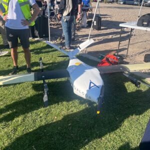
A Showcase of Cutting-Edge Drone Technology in Action Amidst a Stunning Desert Landscape by DRONELIFE Contributor Paul Rossi The early morning sun shines over the gathering, with a large screen displaying the live drone demonstrations for the attendees. This morning’s live flight demonstration at the Commercial UAV Expo hosted by Sundance Media Group was a … [Read more...] about Live Flight Demonstrations: From the Field at Commercial UAV Expo
Drone-Based LiDAR for Explosive Ordnance Disposal Units: More than Mapping
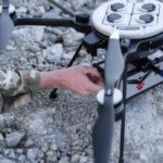
Drone-based LiDAR systems are being used by Explosive Ordnance Disposal (EOD) technicians for 3D mapping, in a successful transfer of technology from DoD laboratories to the field. "RedTail LiDAR Systems, a leader in microelectromechanical systems (MEMS) mirror-based light detection and ranging (LiDAR) technology, has delivered six LiDAR systems to the 707th Ordnance Company … [Read more...] about Drone-Based LiDAR for Explosive Ordnance Disposal Units: More than Mapping


