• Skip to main content
  • Skip to secondary menu
  • Skip to primary sidebar
  • Skip to secondary sidebar
  • Skip to footer
  • DroneRacingLife
  • DroneFlyers
  • Newsletter
DroneLife

DRONELIFE

Stay up to date on all the latest Drone News

  • News
  • Products
  • Industries
    • Agriculture
    • Construction
    • Delivery
    • Dual Use
    • Inspection
    • Public Safety
    • Surveying
  • Enthusiasts
  • Regulations
  • Business
  • Video
  • Podcasts

DroneDeploy Gives a “Peek Under the Hood” of MapEngine

October 11, 2018 by Miriam McNabb 2 Comments

DroneDeploy‘s annual user conference opened today in San Francisco; and in addition to training opportunities, partner demonstrations, and a lot of face time with other drone professionals;, the company is offering a closer look at the technology behind their industry-leading platform.

DroneDeploy co-founder Jono Millin said in his opening remarks that working in the drone space offers a unique opportunity.  When speaking with users, says Millin: “I get to watch an entire industry being formed in front of my eyes.”

To help those users understand DroneDeploy’s focus and get the best out of their platform, Nicholas Pilkington, co-founder and CTO, kicked off the day with an introduction to photogrammetry and MapEngine, explaining how the process works to create high quality mapping and measurements.

MapEngine’s focus is three-fold.  The platform is “Cloud-charged – so that we can always take advantage of the latest and greatest hardware,” explains Pilkington.  “It’s industry-tuned: we’re focused on drone imagery in the industries our customers care about most.  And it’s in your pocket.  Much of our technology is being developed for mobile.”

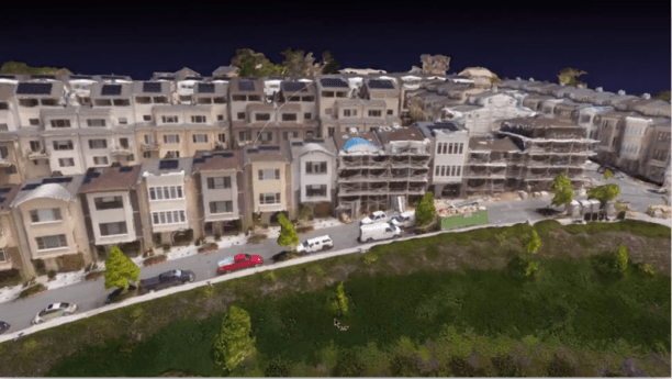
Pilkington then went on to explain how MapEngine takes aerial images and creates high quality output.  “Photogrammetry means measuring using light,” says Pilkington.  “And it  starts with the camera.  Distortion , even slight, is an issue when you are measuring things…scale is also an issue, it’s difficult to see how big things are from a photograph.”

“We’re creating a 3D reconstruction,” says Pilkington.  “We’re not just stitching images together out on the ground – that’s not a true orthomosaic or map.  You need perspective, true reconstructions looked at from the top down. ”

MapEngine is a sophisticated piece of software that takes images and applies a series of processes to reach the end product:

  • Calibration – the software matches points in multiple images, determines the internal geometry of the camera and establishes where the images were taken.
  • Densify – the software uses neighboring views to estimate the depth of pixels in an image. Then MapEngine fuses depth maps into a dense point cloud.
  • Meshing – MapEngine fits a surface through the dense point cloud to mitigate holes, noise, outliers, and misalignment.
  • Texturing – the software generates 3D model texture using views perpendicular to each surface to color in the point cloud.

Finally, the software generates an orthomosaic using nadir views, looking straight down at the 3D model from the top to create the map.

It’s a simplified explanation of the complex process that the software performs, but it helps users understand what the software is looking for in order to provide better data to get a better output. If those steps weren’t obvious, that’s because DroneDeploy has worked to make the process seamless for the user. “We make a huge investment in making this as fast as possible and as useful as possible,” says Pilkington.

In addition to Pilkington’s MapEngine discussion, today’s conference content was in-depth and focused on professionals.  “The vast majority of the people in this room are actually using drones to provide value,” explains Millin. “That makes this a special conference.”

Miriam McNabb

Miriam McNabb is the Editor-in-Chief of DRONELIFE and CEO of JobForDrones, a professional drone services marketplace, and a fascinated observer of the emerging drone industry and the regulatory environment for drones. Miriam has penned over 3,000 articles focused on the commercial drone space and is an international speaker and recognized figure in the industry.  Miriam has a degree from the University of Chicago and over 20 years of experience in high tech sales and marketing for new technologies.
For drone industry consulting or writing, Email Miriam.

TWITTER:@spaldingbarker

Subscribe to DroneLife here.

Filed Under: Drone News Feeds, News Tagged With: Commercial Drones, drone conferences, drone mapping, Drone Software, DroneDeploy, MapEngine

Reader Interactions

Trackbacks

  1. DroneDeploy Gives a “Peek Under the Hood” of MapEngine | News and Reviews about Drones, Quadcopter, Camera says:
    October 12, 2018 at 10:35 am

    […] Source link […]

    Reply
  2. DroneDeploy Gives a “Peek Under the Hood” of MapEngine - Drones Crunch says:
    October 11, 2018 at 6:13 pm

    […] DRONELIFE […]

    Reply

Leave a Reply Cancel reply

Your email address will not be published. Required fields are marked *

Primary Sidebar

LATEST

FCC Adds More Drone Exemptions to Covered List Ban: Elevon Aerial, Air6 Systems

New FCC notice expands the list of conditionally approved foreign-made drone systems exempted from the agency’s broad Covered List restrictions…

Continue Reading FCC Adds More Drone Exemptions to Covered List Ban: Elevon Aerial, Air6 Systems

Students Compete in XPRIZE Wildfire Finals With AI Drone Firefighting

Silicon Valley students take on pros with wildfire drones. By Dronelife Features Editor Jim Magill

https://dronelife.com/wp-content/uploads/2026/05/Powerus_xFold-DragonH-Fire.mp4
The…

Continue Reading Students Compete in XPRIZE Wildfire Finals With AI Drone Firefighting

Robin Radar Names Homeland Security and Defense Leads for US Expansion

The Hague-based maker of the IRIS drone-detection radar adds senior US sales leadership and larger Virginia headquarters as homeland security…

Continue Reading Robin Radar Names Homeland Security and Defense Leads for US Expansion

Buffalo’s Natrion Rolls Out NDAA-Compliant Drone Battery Cells

The Buffalo-based battery materials company debuts NDAA-compliant pouch cells with up to 80% more energy density than standard Li-ion. Natrion…

Continue Reading Buffalo’s Natrion Rolls Out NDAA-Compliant Drone Battery Cells

ePropelled Launches Integrated Power System for Agricultural Drones

New propulsion platform targets growing precision agriculture UAV market As agricultural drone adoption continues to expand worldwide, ePropelled has introduced…

Continue Reading ePropelled Launches Integrated Power System for Agricultural Drones

FAA and DoD Are Building the Rules for Drones Operating Near Sensitive Airspace

FAA and DoD Explore How Drones, Counter-UAS Systems, and Airports Can Share Airspace XPONENTIAL panel highlights growing cooperation between civil…

Continue Reading FAA and DoD Are Building the Rules for Drones Operating Near Sensitive Airspace

Urban UAV Operations Need More than Drones

Cloud Century has implemented more than 200 drone docks in China, learning what urban drone operations require. In this guest…

Continue Reading Urban UAV Operations Need More than Drones

MatrixSpace Brings Portable Counter-Drone Radar to Lithuanian Exercise

The xTechCounter Strike winner deploys portable AI-powered radar to strengthen low-altitude airspace awareness for M-SHORAD units in Pabradė. MatrixSpace is…

Continue Reading MatrixSpace Brings Portable Counter-Drone Radar to Lithuanian Exercise

Industrial Policy and Wright’s Law: A New Perspective on Building the U.S. Drone Industry

At the AUVSI XPONENTIAL 2026 conference this week, Red Cat Holdings executive Brendan Stewart delivered one of the more historically…

Continue Reading Industrial Policy and Wright’s Law: A New Perspective on Building the U.S. Drone Industry

How DHS Is Helping World Cup Host Cities Get Counter-UAS Ready Before FIFA 2026

DHS lab equips World Cup cities with counter-drone guidance. By DRONELIFE Features Editor Jim Magill (Editor’s note: This is part…

Continue Reading How DHS Is Helping World Cup Host Cities Get Counter-UAS Ready Before FIFA 2026

Secondary Sidebar

Footer

SPONSORED

Inspired Flight Gremsy IF800 VIO F1 drones geo week

What Will It Take to Strengthen U.S. Drone Manufacturing? A Conversation with Inspired Flight’s CEO

Global Mapper Mobile data collection

Collection Ground Control Points with Global Mapper Mobile

Military Drone Mapping Solutions

How SimActive’s Correlator3D™ is Revolutionizing Military Mapping: An Exclusive Interview with CEO Philippe Simard

Photogrammetry Accuracy Standards

SimActive Photogrammetry Software: Enabling Users to Meet Accuracy Standards for Over 20 Years

NACT Engineering Parrot ANAFI tether indoor shot

Smart Tether for Parrot ANAFI USA from NACT Engineering

Blue Marble, features global mapper, features Blue Marble

Check Out These New Features in Global Mapper v25 from Blue Marble

About Us | Contact Us | Advertise With Us | Write for Us | Privacy Policy | Terms of Service

The Trusted Source for the Business of Drones.

This website uses cookies and third party services. By clicking OK, you are agreeing to our privacy policy. ACCEPT

Manage consent

Privacy Overview

This website uses cookies to improve your experience while you navigate through the website. Out of these, the cookies that are categorized as necessary are stored on your browser as they are essential for the working of basic functionalities of the website. We also use third-party cookies that help us analyze and understand how you use this website. These cookies will be stored in your browser only with your consent. You also have the option to opt-out of these cookies. But opting out of some of these cookies may affect your browsing experience.
Necessary
Always Enabled
Necessary cookies are absolutely essential for the website to function properly. These cookies ensure basic functionalities and security features of the website, anonymously.
CookieDurationDescription
cookielawinfo-checkbox-analytics11 monthsThis cookie is set by GDPR Cookie Consent plugin. The cookie is used to store the user consent for the cookies in the category "Analytics".
cookielawinfo-checkbox-functional11 monthsThe cookie is set by GDPR cookie consent to record the user consent for the cookies in the category "Functional".
cookielawinfo-checkbox-necessary11 monthsThis cookie is set by GDPR Cookie Consent plugin. The cookies is used to store the user consent for the cookies in the category "Necessary".
cookielawinfo-checkbox-others11 monthsThis cookie is set by GDPR Cookie Consent plugin. The cookie is used to store the user consent for the cookies in the category "Other.
cookielawinfo-checkbox-performance11 monthsThis cookie is set by GDPR Cookie Consent plugin. The cookie is used to store the user consent for the cookies in the category "Performance".
viewed_cookie_policy11 monthsThe cookie is set by the GDPR Cookie Consent plugin and is used to store whether or not user has consented to the use of cookies. It does not store any personal data.
Functional
Functional cookies help to perform certain functionalities like sharing the content of the website on social media platforms, collect feedbacks, and other third-party features.
Performance
Performance cookies are used to understand and analyze the key performance indexes of the website which helps in delivering a better user experience for the visitors.
Analytics
Analytical cookies are used to understand how visitors interact with the website. These cookies help provide information on metrics the number of visitors, bounce rate, traffic source, etc.
Advertisement
Advertisement cookies are used to provide visitors with relevant ads and marketing campaigns. These cookies track visitors across websites and collect information to provide customized ads.
Others
Other uncategorized cookies are those that are being analyzed and have not been classified into a category as yet.
SAVE & ACCEPT