Exhibitors, product launches, and presentations highlight drones’ expanding role in mapping, monitoring, and emergency response. The world’s largest geospatial event, INTERGEO 2025, returns to Frankfurt from October 7–9, 2025. This year, drones and unmanned systems are in the spotlight across the exhibition floor and conference stages. From new product launches to in-depth … [Read more...] about Headed to INTERGEO 2025? Unmanned Systems Take Center Stage in Frankfurt
Blue Marble Geographics
Headed to Commercial UAV Expo 2025? Can’t-Miss Partners, Innovations, and Keynotes in Las Vegas

The Commercial UAV Expo returns to Las Vegas September 2 to 4, 2025, bringing together more than 3,500 professionals from over 70 countries at Caesars Forum. This year’s event carries even greater weight as it is the first major industry gathering since the FAA released its long awaited Part 108 Beyond Visual Line of Sight (BVLOS) NPRM, now in its public comment period. With … [Read more...] about Headed to Commercial UAV Expo 2025? Can’t-Miss Partners, Innovations, and Keynotes in Las Vegas
Blue Marble Geographics Offers Live Webinar on Bathymetry and Terrain Analysis
Hallowell, ME-based mapping company Blue Marble Geographics will host a free webinar on Thursday, August 21, at 10:00 AM EDT, focusing on bathymetry and terrain analysis with their software Global Mapper Pro. This event, which also serves as the debut live show of the GEOTalks Podcast, aims to help participants understand how geographic information system (GIS) professionals … [Read more...] about Blue Marble Geographics Offers Live Webinar on Bathymetry and Terrain Analysis
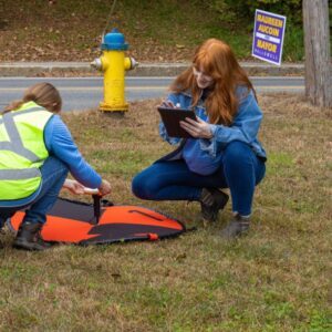
Drone Mapping Transforms Police Crash Investigations: A Blue Marble Geographics Case Study

Drones are rapidly becoming indispensable tools for law enforcement, not only for real-time situational awareness and Drone as First Responder (DFR) programs, but also for post-incident documentation and analysis. A recent case study from Blue Marble Geographics, featuring the Windham, Maine Police Department, illustrates how drone mapping is revolutionizing crash … [Read more...] about Drone Mapping Transforms Police Crash Investigations: A Blue Marble Geographics Case Study
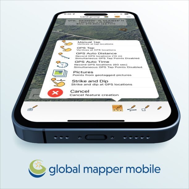
Collection Ground Control Points with Global Mapper Mobile
Effortless Field Data Collection with Global Mapper Mobile Global Mapper Mobile brings data collection into the palm of your hand, making it easy to record ground control points and other key features on site when collecting drone-images for processing in Global Mapper desktop’s Pixels to Points tool. Available on iOS and Android mobile operating systems, Global Mapper Mobile … [Read more...] about Collection Ground Control Points with Global Mapper Mobile