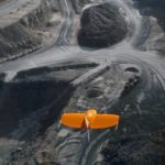
Swiss drone manufacturer Wingtra this week announced the launch of the WingtraOne PPK (Post-Processed Kinematics) model. Working with photogrammetry software provider Pix4D and PPK provider Septentrio, the company says it can now provide orthomosaics mapping and 3D models “with an absolute accuracy down to .4 inches.” Several industry sectors – mining, construction, … [Read more...] about Wingtra’s New Drone Sets Benchmark in Precision Mapping
3d mapping
What’s the Difference Between 3D Modeling and 3D Mapping?
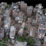
If you've ever wondered what the difference is between 3D modeling and 3D mapping, you're not alone. There is some overlap between the two in technology and solutions. We asked the experts at Pix4D to explain the difference. Pix4D is one of the leading providers of photogrammetry solutions for drones, creating both 2D and 3D information from images. Dr. Christoph Strecha, … [Read more...] about What’s the Difference Between 3D Modeling and 3D Mapping?
So Much For Pictures of the Pool: Pix4D Shows Off the Ultimate Real Estate Experience

The days of trying to sell a home to distant home buyers by carefully cropping out the recycling center next door from the pictures are over, thanks to drone mapping. Even aerial images that show off the landscaping are now old school. Pix4D, the Swiss photogrammetry-powered, drone-based solution provider, has released a sample website demonstrating the ultimate property … [Read more...] about So Much For Pictures of the Pool: Pix4D Shows Off the Ultimate Real Estate Experience


