• Skip to main content
  • Skip to secondary menu
  • Skip to primary sidebar
  • Skip to secondary sidebar
  • Skip to footer
  • DroneRacingLife
  • DroneFlyers
  • Newsletter
DroneLife

DRONELIFE

Stay up to date on all the latest Drone News

  • News
  • Products
  • Industries
    • Agriculture
    • Construction
    • Delivery
    • Dual Use
    • Inspection
    • Public Safety
    • Surveying
  • Enthusiasts
  • Regulations
  • Business
  • Video
  • Podcasts

What’s the Difference Between 3D Modeling and 3D Mapping?

April 18, 2017 by Miriam McNabb 14 Comments

image: Pix4D

If you’ve ever wondered what the difference is between 3D modeling and 3D mapping, you’re not alone.  There is some overlap between the two in technology and solutions.  We asked the experts at Pix4D to explain the difference.

Pix4D is one of the leading providers of photogrammetry solutions for drones, creating both 2D and 3D information from images.  Dr. Christoph Strecha, Pix4D’s founder and CEO, says that the difference is in how the data is used.  “There is no difference scientifically,” explains Strecha.  “A map is really 2D, something flat – but with modeling, the result is not a 2D map but a triangulated model where you can also see facades.”

3D Mapping

While the map is flat, most drone technology companies call it 3D mapping – because creating an accurate map from aerial images gives a result that doesn’t look anything like the kind of map you buy in a gas station.  Instead, it’s a precise picture of terrain – including all of the buildings and natural components of the terrain.  It can give a sense of size and depth.  It’s often combined with other information, such as thermographic data or industry specific data (think agriculture crop counting systems) to make the map an actionable tool.

image: Pix4D
image: Pix4D

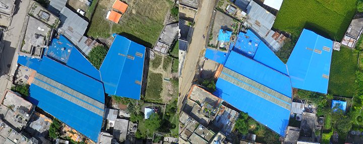
Data solutions use photogrammetry (the science of taking measurements from pictures) and orthomosaics to create 3D maps.  Orthomosaics is a combination of  processes.  Ortho-rectifying or creating an orthophoto means adjusting an image for topographic relief, lens distortion, and camera tilt: allowing it to be used for true measurement.  “Mosaics” is stitching together multiple images into one.  The resulting maps – now highly accurate – can be used for a wide range of industrial applications, such as construction, surveying, urban planning, and land management.

3D Modeling

Strecha says that more and more clients now want to go beyond mapping into 3D modeling.  “Even in traditional surveying and mapping, the needs are changing,” says Strecha.  “On the professional side, there is more and more interest in 3D modeling.”  Strecha uses the example of the ubiquitous Google maps – once strictly 2D but now giving users the experience of walking down a neighborhood street, viewing the houses.

While the equipment required is the same for both processes, drone operators who want a 3D model as a result will need to provide more oblique shots, providing images of the facades.  With those, modeling software can create realistic 3D models or fly-through videos.

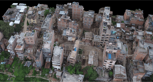
3D modeling can be used for commercial purposes like real estate; or, like the image at the top of the page, to create more informative maps.

Applications

There is good news for the drone operator: processing software and platforms can do all the work, building maps or models from the images they provide.  The operator may just need to make their client aware of what’s available.  While agronomists may still find 3D maps most useful, construction, geospatial or real estate applications are finding more benefit from 3D modeling.


Miriam McNabb

Miriam McNabb is the Editor-in-Chief of DRONELIFE and CEO of JobForDrones, a professional drone services marketplace, and a fascinated observer of the emerging drone industry and the regulatory environment for drones. Miriam has penned over 3,000 articles focused on the commercial drone space and is an international speaker and recognized figure in the industry.  Miriam has a degree from the University of Chicago and over 20 years of experience in high tech sales and marketing for new technologies.
For drone industry consulting or writing, Email Miriam.

TWITTER:@spaldingbarker

Subscribe to DroneLife here.

Filed Under: DL Exclusive, News Tagged With: 3d mapping, 3d modelling software, commercial drone platform, commercial drone software., Pix4D

Reader Interactions

Trackbacks

  1. 3D Drone Mapping: Inside Parrot’s “Impossible” Mission Over Positano [VIDEO] - DroneDaddy says:
    November 3, 2021 at 3:03 pm

    […] Logiroad, a French software company with expertise in creating digital twins of cities, to create a 3D model of the picturesque but hard-to-map […]

    Reply
  2. Pix 4D Celebrates 10 Year Anniversary: Paying Homage to its History - The Drone Page says:
    June 1, 2021 at 12:34 pm

    […] is celebrating its 10 year anniversary with social media posts and an upcoming interview feature with Christoph Strecha. Pix4D is a world-leading photogrammetry specialist and will continue to innovate, develop, and […]

    Reply
  3. Thanks big fan here – Drones With Camera HD says:
    February 13, 2019 at 5:01 am

    […] drone technology emerges, more mapping professionals recognize the importance of 3D modeling, according to JobForDrones.com CEO Miriam McNabb. Drone technology has had such a big impact on the surveying […]

    Reply
  4. Anything related to is so important – Drones With Camera HD says:
    February 13, 2019 at 3:00 am

    […] drone technology emerges, more mapping professionals recognize the importance of 3D modeling, according to JobForDrones.com CEO Miriam McNabb. Drone technology has had such a big impact on the surveying […]

    Reply
  5. anyone else love this as much as i do – Drones With Camera HD says:
    February 13, 2019 at 12:11 am

    […] drone technology emerges, more mapping professionals recognize the importance of 3D modeling, according to JobForDrones.com CEO Miriam McNabb. Drone technology has had such a big impact on the surveying […]

    Reply
  6. Amazing I love – Drones With Camera HD says:
    February 12, 2019 at 8:05 pm

    […] drone technology emerges, more mapping professionals recognize the importance of 3D modeling, according to JobForDrones.com CEO Miriam McNabb. Drone technology has had such a big impact on the surveying […]

    Reply
  7. 5 Fields of Strong Growth for Professional Drone Pilots – Don't Drone Me! says:
    February 12, 2019 at 12:12 am

    […] drone technology emerges, more mapping professionals recognize the importance of 3D modeling, according to JobForDrones.com CEO Miriam McNabb. Drone technology has had such a big impact on the surveying […]

    Reply
  8. 5 Fields of Robust Development for Skilled Drone Pilots - Gadgets Now Website says:
    February 11, 2019 at 5:30 pm

    […] drone expertise emerges, extra mapping professionals acknowledge the significance of 3D modeling, in accordance to JobForDrones.com CEO Miriam McNabb. Drone expertise has had such a huge impact on the surveying […]

    Reply
  9. 5 Fields of Strong Growth for Professional Drone Pilots – Air and Ground says:
    February 11, 2019 at 5:08 pm

    […] drone technology emerges, more mapping professionals recognize the importance of 3D modeling, according to JobForDrones.com CEO Miriam McNabb. Drone technology has had such a big impact on the surveying […]

    Reply
  10. I always love anything like this – Drones With Camera HD says:
    February 11, 2019 at 4:01 pm

    […] drone technology emerges, more mapping professionals recognize the importance of 3D modeling, according to JobForDrones.com CEO Miriam McNabb. Drone technology has had such a big impact on the surveying […]

    Reply
  11. 5 Fields of Strong Growth for Professional Drone Pilots - Drones Crunch says:
    February 11, 2019 at 3:19 pm

    […] drone technology emerges, more mapping professionals recognize the importance of 3D modeling, according to JobForDrones.com CEO Miriam McNabb. Drone technology has had such a big impact on the surveying […]

    Reply
  12. drone helicopter | Inspection Drones Illuminate Duke Energy’s World says:
    March 13, 2018 at 11:04 am

    […] the program’s inception four years ago, Duke has improved the program by adding Pix4Dmapper Pro for Orthomosaic to map, stitch still images and enhance […]

    Reply
  13. Inspection Drones Illuminate Duke Energy’s World - Drones Crunch says:
    March 12, 2018 at 10:59 pm

    […] the program’s inception four years ago, Duke has improved the program by adding Pix4Dmapper Pro for Orthomosaic to map, stitch still images and enhance […]

    Reply
  14. The Difference Between 3D Modeling and 3D Mapping Explained - Daily Drone News says:
    April 19, 2017 at 6:13 am

    […] Read the full story here. […]

    Reply

Leave a Reply Cancel reply

Your email address will not be published. Required fields are marked *

Primary Sidebar

LATEST

National Resilience Strategy Connects the Dots Behind U.S. Drone Policy

New White House strategy frames commercial drones as part of a broader effort to strengthen U.S. manufacturing, infrastructure, and supply…

Continue Reading National Resilience Strategy Connects the Dots Behind U.S. Drone Policy

Beyond the Drone: Percepto’s New Platform Brings AI to Infrastructure Inspections

Percepto launches next-gen inspection software By DRONELIFE Features Editor Jim Magill For energy companies, producing actionable data is almost as…

Continue Reading Beyond the Drone: Percepto’s New Platform Brings AI to Infrastructure Inspections

Danish Investigation Finds No Proof Drones Caused Copenhagen Airport Shutdown

Nine-month investigation underscores the need for better airspace awareness, not just more speculation News and Commentary.  A nine-month investigation into…

Continue Reading Danish Investigation Finds No Proof Drones Caused Copenhagen Airport Shutdown

Flytrex and Wing Report Zero Airspace Conflicts for Multi-Operator Drone Delivery

Flytrex says automated UTM coordination with Wing has deconflicted 100% of operations in Dallas–Fort Worth shared airspace, with zero conflicts.…

Continue Reading Flytrex and Wing Report Zero Airspace Conflicts for Multi-Operator Drone Delivery

BRINC Partnership Gives Public Safety Agencies an “Immediate Upgrade” in Incident Intelligence

BRINC and Nova Partner to Add Advanced Mapping and Thermal Intelligence for Public Safet Public safety drone manufacturer BRINC has…

Continue Reading BRINC Partnership Gives Public Safety Agencies an “Immediate Upgrade” in Incident Intelligence

Prodrone Debuts All-Japanese Industrial Drone

This article published in collaboration with JUIDA, the Japan UAS Industrial Development Association.     Aichi-based Prodrone introduces the PD4B-MS prototype,…

Continue Reading Prodrone Debuts All-Japanese Industrial Drone

Uruguayan Government Announces New Drone Dispatch Program

The Montevideo deployment, run in partnership with Uruguayan technology firm Timerix, ties gunshot-detection alerts to automated drone dispatch and live…

Continue Reading Uruguayan Government Announces New Drone Dispatch Program

Utilities Prepare for BVLOS While Navigating the Post-DJI Transition

Utilities face challenges in establishing drone programs By DRONELIFE Features Editor Jim Magill While the owners of electric utility assets…

Continue Reading Utilities Prepare for BVLOS While Navigating the Post-DJI Transition

FCC Drone Exemption List Offers Clues to Trusted Supplier Requirements

Six months of conditional approvals reveal a broad range of accepted drone applications, while key details of the review process…

Continue Reading FCC Drone Exemption List Offers Clues to Trusted Supplier Requirements

China’s Export Restrictions on Red Cat Highlight a Bigger Challenge for U.S. Drone Manufacturing

Recent Chinese export controls targeting Red Cat may have limited immediate impact, but they underscore why U.S. drone manufacturers are…

Continue Reading China’s Export Restrictions on Red Cat Highlight a Bigger Challenge for U.S. Drone Manufacturing

Secondary Sidebar

Footer

SPONSORED

Inspired Flight Gremsy IF800 VIO F1 drones geo week

What Will It Take to Strengthen U.S. Drone Manufacturing? A Conversation with Inspired Flight’s CEO

Global Mapper Mobile data collection

Collection Ground Control Points with Global Mapper Mobile

Military Drone Mapping Solutions

How SimActive’s Correlator3D™ is Revolutionizing Military Mapping: An Exclusive Interview with CEO Philippe Simard

Photogrammetry Accuracy Standards

SimActive Photogrammetry Software: Enabling Users to Meet Accuracy Standards for Over 20 Years

NACT Engineering Parrot ANAFI tether indoor shot

Smart Tether for Parrot ANAFI USA from NACT Engineering

Blue Marble, features global mapper, features Blue Marble

Check Out These New Features in Global Mapper v25 from Blue Marble

About Us | Contact Us | Advertise With Us | Write for Us | Privacy Policy | Terms of Service

The Trusted Source for the Business of Drones.

This website uses cookies and third party services. By clicking OK, you are agreeing to our privacy policy. ACCEPT

Manage consent

Privacy Overview

This website uses cookies to improve your experience while you navigate through the website. Out of these, the cookies that are categorized as necessary are stored on your browser as they are essential for the working of basic functionalities of the website. We also use third-party cookies that help us analyze and understand how you use this website. These cookies will be stored in your browser only with your consent. You also have the option to opt-out of these cookies. But opting out of some of these cookies may affect your browsing experience.
Necessary
Always Enabled
Necessary cookies are absolutely essential for the website to function properly. These cookies ensure basic functionalities and security features of the website, anonymously.
CookieDurationDescription
cookielawinfo-checkbox-analytics11 monthsThis cookie is set by GDPR Cookie Consent plugin. The cookie is used to store the user consent for the cookies in the category "Analytics".
cookielawinfo-checkbox-functional11 monthsThe cookie is set by GDPR cookie consent to record the user consent for the cookies in the category "Functional".
cookielawinfo-checkbox-necessary11 monthsThis cookie is set by GDPR Cookie Consent plugin. The cookies is used to store the user consent for the cookies in the category "Necessary".
cookielawinfo-checkbox-others11 monthsThis cookie is set by GDPR Cookie Consent plugin. The cookie is used to store the user consent for the cookies in the category "Other.
cookielawinfo-checkbox-performance11 monthsThis cookie is set by GDPR Cookie Consent plugin. The cookie is used to store the user consent for the cookies in the category "Performance".
viewed_cookie_policy11 monthsThe cookie is set by the GDPR Cookie Consent plugin and is used to store whether or not user has consented to the use of cookies. It does not store any personal data.
Functional
Functional cookies help to perform certain functionalities like sharing the content of the website on social media platforms, collect feedbacks, and other third-party features.
Performance
Performance cookies are used to understand and analyze the key performance indexes of the website which helps in delivering a better user experience for the visitors.
Analytics
Analytical cookies are used to understand how visitors interact with the website. These cookies help provide information on metrics the number of visitors, bounce rate, traffic source, etc.
Advertisement
Advertisement cookies are used to provide visitors with relevant ads and marketing campaigns. These cookies track visitors across websites and collect information to provide customized ads.
Others
Other uncategorized cookies are those that are being analyzed and have not been classified into a category as yet.
SAVE & ACCEPT