- Blue Innovation Deploys Drones for Nighttime Wildfire Imaging in JapanThis article published in collaboration with JUIDA, the Japan UAS Industrial Development Association. Blue Innovation Co., Ltd. deployed drones for nighttime aerial imaging during a forest fire on Mount Ogi in Yamanashi Prefecture, Japan. The company responded to a dispatch request from the Japan Ground Self-Defense Force (JGSDF) Eastern Army, relayed through the Japan… Read more: Blue Innovation Deploys Drones for Nighttime Wildfire Imaging in Japan
- Windracers ULTRA to Map Greenland’s Petermann Glacier
 By Dronelife Features Editor Jim Magill An international team of researchers plans to deploy Windracers’ dual-use heavy-lift drone technology to study the interactions of ice and ocean water in the frigid Arctic region of northwestern Greenland. The study, which is expected to get under way this summer, will be a critical part of the so-called GIANT… Read more: Windracers ULTRA to Map Greenland’s Petermann Glacier
 - Spexi Orthomosaic Drone Imagery Now Available on SkyWatch Platform
 SkyWatch has announced the addition of Spexi orthomosaic drone imagery to its platform, expanding access to standardized aerial data for mapping and analysis. The integration allows users to source ultra-high-resolution drone imagery directly through SkyWatch’s EXPLORE and HUB applications. With the launch, SkyWatch customers can access Spexi’s stitched, orthorectified imagery over 38 cities across North… Read more: Spexi Orthomosaic Drone Imagery Now Available on SkyWatch Platform
 - Phase One Unveils iXM-FS130 Camera for Sub-Centimeter Aerial Mapping

 Phase One has announced the iXM-FS130, a next-generation aerial mapping camera designed to capture sub-centimeter ground sample distance imagery from fixed-wing aircraft at speeds exceeding 120 knots. The camera introduces Phase One’s patented Fusion Shutter technology to the commercial aerial mapping market. This enables operators to maintain image quality while increasing mission efficiency. Fusion Shutter… Read more: Phase One Unveils iXM-FS130 Camera for Sub-Centimeter Aerial Mapping
 - Wingcopter 198 Drones to Support Aerial Surveying in Japan
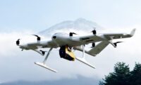
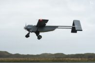
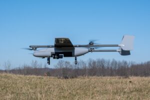
 Wingcopter’s long-range Wingcopter 198 drone will be deployed for aerial surveying in Japan under a new collaboration between ITOCHU Corporation, PASCO Corporation, and YellowScan Japan Co., Ltd. The partners have signed an MOU to apply the platform to disaster management, terrain mapping, and post-event restoration tasks. The Wingcopter 198 combines vertical takeoff and landing (VTOL) capability with fixed-wing flight… Read more: Wingcopter 198 Drones to Support Aerial Surveying in Japan
 - SPH Engineering Adds 600 MHz UAV GPR Antennas for High-Resolution Subsurface Mapping
 SPH Engineering has expanded its drone-based ground-penetrating radar (GPR) portfolio with two 600 MHz antennas designed for UAV integration: the MALÅ GeoDrone 600 and the Zond Aero 600 NG. The new systems are aimed at high-resolution subsurface mapping in engineering, utility detection, archaeology, environmental studies, and geophysical research, particularly where access for ground carts is… Read more: SPH Engineering Adds 600 MHz UAV GPR Antennas for High-Resolution Subsurface Mapping
 - From Intergeo 2025: Digital Twin Technology Preserves Alcatraz Island
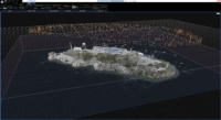
 A groundbreaking digital preservation project has created the most comprehensive 3D map of Alcatraz Island ever produced, combining cutting-edge drone technology, artificial intelligence, and reality capture systems to document one of America’s most notorious historical sites. Pete Kelsey, founder of VCTO Labs, presented the remarkable achievements of this ambitious project at Intergeo 2025 in Frankfurt,… Read more: From Intergeo 2025: Digital Twin Technology Preserves Alcatraz Island
 - Orkid Unveils All-in-One Drone Combining LiDAR, Photogrammetry, GNSS, and Starlink
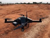
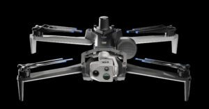
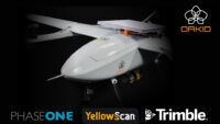 Orkid has announced a new variant of its ORKID 260 vertical take-off and landing (VTOL) drone, bringing together four of the most advanced aerial data capture technologies into one integrated, NDAA-compliant system. The ORKID 260VTOL integrated drone combines LiDAR, photogrammetry, GNSS, and Starlink satellite connectivity onboard, allowing all systems to operate simultaneously. The drone features… Read more: Orkid Unveils All-in-One Drone Combining LiDAR, Photogrammetry, GNSS, and Starlink
 - Photogrammetry vs. LiDAR: Choosing the Right Tool for the Job, with Dr. Philippe Simard
 SimActive Inc. has played a pivotal role in the evolution of geospatial data processing since its founding in 2003. Leading the company is Dr. Philippe Simard, a pioneer in the industry with a doctorate in electrical engineering from McGill University, specializing in computer vision. Under Dr. Simard’s leadership, SimActive’s flagship software, Correlator3D™, has become a… Read more: Photogrammetry vs. LiDAR: Choosing the Right Tool for the Job, with Dr. Philippe Simard
 - Enhancing Drone Mapping with RTK and PPK: Insights from SimActive’s Eric Andelin
 Drone mapping technology has advanced significantly in recent years, with Real-Time Kinematic (RTK) and Post-Processed Kinematic (PPK) positioning emerging as game-changing technologies. These methods enhance mapping accuracy and efficiency, reducing reliance on traditional Ground Control Points (GCPs). SimActive, a leading provider of photogrammetry software, offers powerful tools for geospatial professionals, including its flagship product, Correlator3D.… Read more: Enhancing Drone Mapping with RTK and PPK: Insights from SimActive’s Eric Andelin
 - Wingcopter Expands into Long-Range LiDAR Surveying

 New Application Enables Efficient Infrastructure and Terrain Mapping Wingcopter has announced an expansion of its offerings to include long-range beyond visual line of sight (BVLOS) LiDAR surveying solutions. The Wingcopter 198, the company’s flagship drone, will be equipped with advanced laser scanning and camera systems to enable rapid, high-quality data collection. The new system allows… Read more: Wingcopter Expands into Long-Range LiDAR Surveying
 - GeoCue and Clogworks Technologies Announce Partnership to Expand LiDAR Drone Mapping Solutions
 New Collaboration Enhances Aerial Surveying Capabilities with Integrated LiDAR and Software Solutions GeoCue has announced a new partnership with UK-based drone manufacturer Clogworks Technologies Limited. This collaboration integrates GeoCue’s TrueView LiDAR and LP360 software with Clogworks’ Dark Matter series of UAVs. The partnership aims to provide surveyors and mapping professionals with an efficient, all-in-one data… Read more: GeoCue and Clogworks Technologies Announce Partnership to Expand LiDAR Drone Mapping Solutions
 - North Carolina Drone Photographer Seeks Supreme Court Support for First Amendment Rights
 Michael Jones asks the court to uphold his right to provide aerial information to clients. Yesterday, the Institute for Justice (IJ) filed a petition with the United States Supreme Court on behalf of Michael Jones, a drone photographer in North Carolina. The case brings forward an important question: does providing data and information through aerial… Read more: North Carolina Drone Photographer Seeks Supreme Court Support for First Amendment Rights
 - New Drones in India: Surveyaan V1 Receives Certification
 Surveyaan V1 Drone by Nibrus Technologies Receives DGCA Type Certification New Certification Marks a Milestone for India’s Drone Industry Nibrus Technologies, a drone manufacturer in India, has announced that its Surveyaan V1 drone has received Type Certification from the Directorate General of Civil Aviation (DGCA). This accomplishment represents a significant achievement for Nibrus Technologies, reinforcing… Read more: New Drones in India: Surveyaan V1 Receives Certification
 - North Carolina Drone Operator to Seek Further Review in First Amendment Lawsuit
 Appeals Court Upholds Ban on Aerial Mapping by Non-Surveyors A three-judge panel of the 4th U.S. Circuit Court of Appeals has ruled that North Carolina can prohibit the creation of aerial maps by anyone other than licensed land surveyors. This decision affects Michael Jones, a drone operator based in Goldsboro, North Carolina, as well as… Read more: North Carolina Drone Operator to Seek Further Review in First Amendment Lawsuit
 - Pix4D Releases Enhanced PIX4Dcatch 2.0 with AR Features
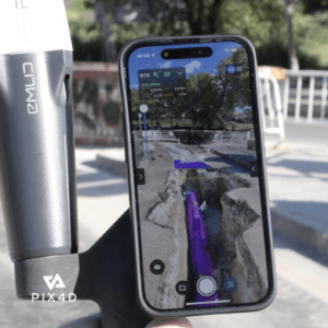
 Latest update integrates professional augmented reality tools for improved precision in AEC sectors. Swiss-based Pix4D, a leading provider of drone and terrestrial mapping solutions, announced today the release of the upgraded version of their mobile scanning app, PIX4Dcatch 2.0. This update introduces augmented reality (AR) capabilities and expands compatibility with various RTK devices, aiming to… Read more: Pix4D Releases Enhanced PIX4Dcatch 2.0 with AR Features
 - SimActive Photogrammetry Software: Enabling Users to Meet Accuracy Standards for Over 20 Years
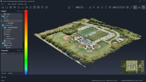 Mastering Precision: Navigating the Evolving Landscape of Photogrammetry with SimActive SimActive, a Montreal-based photogrammetry software company with over 20 years serving the mapping community. From satellites to aircraft and drones, one software for all acquisition platforms, designed to support all sizes of professional photogrammetry providers. Accuracy standards are crucial in promoting consistency, reliability, and quality… Read more: SimActive Photogrammetry Software: Enabling Users to Meet Accuracy Standards for Over 20 Years
 - Event 38 Unmanned Systems Incorporates Advanced LiDAR Technology into E455 Drone
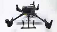
 Event 38 Unmanned Systems Integrates Advanced LiDAR onto E455 Drone Event 38 Unmanned Systems, a global leader in the manufacturing of unmanned aerial vehicles, has announced a significant upgrade to their Heavy VTOL E455 Drone. The drone can now be equipped with multiple LiDAR systems, including the Resepi Hesai LIDAR XT-32 developed by Inertial Labs.… Read more: Event 38 Unmanned Systems Incorporates Advanced LiDAR Technology into E455 Drone
 - Breaking Barriers: Censys Technologies Soars to New Heights with 30-Mile BVLOS Flight Milestone
 Censys Technologies Achieves 30-Mile BVLOS Flight Milestone with Sentaero 5 Censys Technologies conducted a 30-mile beyond visual line of sight (BVLOS) operation on November 17th, successfully flying the Sentaero 5 over a cellular network in South Florida adjacent to Lake Okeechobee. This milestone was achieved by leveraging a performance-based, non-geo constrained shielded operations waiver, marking… Read more: Breaking Barriers: Censys Technologies Soars to New Heights with 30-Mile BVLOS Flight Milestone
 - Skydio, Trimble Partner to Bring Centimeter Level Accuracy to the X10
 Skydio and Trimble Collaborate on New Integration for Utilities, Construction and State Transportation Agencies by DRONELIFE Staff Writer Ian J. McNabb Skydio, a California-based drone and UAV manufacturer focused on autonomy, recently announced a new strategic partnership with Trimble to create new integrated workflows designed to unite data capture, data visualization, and data analytics for… Read more: Skydio, Trimble Partner to Bring Centimeter Level Accuracy to the X10
- Skip to main content
- Skip to secondary menu
- Skip to primary sidebar
- Skip to secondary sidebar
- Skip to footer
DRONELIFE
Stay up to date on all the latest Drone News
Footer
SPONSORED


