- Teledyne FLIR OEM Launches Lepton XDS Dual Thermal-Visible Camera Module
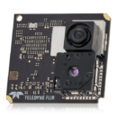
 Compact MSX-Enabled System Targets Rapid OEM Integration Across Embedded and Industrial Applications Teledyne FLIR OEM has introduced the Lepton® XDS, a compact dual thermal and visible camera module, at Mobile World Congress in Barcelona. The new module brings the company’s patented MSX® imaging technology into a small, OEM-ready format. The company says the product is… Read more: Teledyne FLIR OEM Launches Lepton XDS Dual Thermal-Visible Camera Module
 - New Partnership Building Farming Drone Batteries in Texas

 KULR Technology Group and Hylio have entered a joint collaboration to produce NDAA-compliant battery systems for agricultural drones built in Texas. The partnership centers on U.S.-based design and manufacturing to strengthen secure domestic supply chains for drone energy systems. The companies plan to design, prototype, and qualify high-performance batteries for Hylio’s unmanned aerial systems. Engineering… Read more: New Partnership Building Farming Drone Batteries in Texas
 - Sentrycs Scout Expands Counter-Drone Capabilities for Law Enforcement
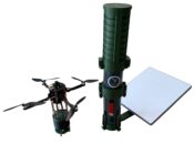
 Sentrycs, an Ondas Inc. subsidiary specializing in counter-drone technology, has delivered its C-UAS solution to a German State Police department. The deployment arrives as Sentrycs prepares to launch its new portable system, Sentrycs Scout, at the Enforce Tac exhibition in Germany. The system uses a proprietary “Cyber over RF” technique, also known as Protocol Manipulation,… Read more: Sentrycs Scout Expands Counter-Drone Capabilities for Law Enforcement
 - Promo Drone Announces New Distribution For Signage Drone

 Promo Drone has partnered with Almo Pro AV to expand use of the Starling X.2 drone-mounted digital sign. The companies plan joint demos, training, and outreach to Pro AV and public safety customers. Starling X.2 drone-mounted digital sign The Starling X.2 is a drone platform that carries an ultra-bright LED sign for digital messaging and… Read more: Promo Drone Announces New Distribution For Signage Drone
 - New Lithium Project Advances in Utah, Supporting Domestic Supply Chains
 Intrepid Potash-Wendover, Aquatech International, and Adionics have advanced their Wendover Lithium Project in Utah, reporting high lithium recovery and battery-grade product quality from potash brine waste streams. The project is positioned as a domestic source of critical minerals that could support electrification and downstream industries, including batteries for uncrewed systems and other defense and aerospace… Read more: New Lithium Project Advances in Utah, Supporting Domestic Supply Chains
 - Amprius Expands Korea Battery Alliance with NDAA-Compliant Manufacturing Network
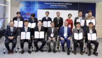
 Amprius Technologies, Inc. (NYSE: AMPX) has announced the expansion of the Amprius Korea Battery Alliance following a successful launch event in Daejeon, South Korea. The battery manufacturer, which specializes in next-generation lithium-ion batteries built on its Silicon Anode Platform, added three contract manufacturers to the consortium, significantly increasing its global production capacity and strengthening NDAA-compliant… Read more: Amprius Expands Korea Battery Alliance with NDAA-Compliant Manufacturing Network
 - Blue Marble Shows How AI and LiDAR Deliver ROI for Rail Operators
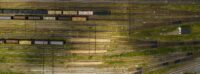
 A New Moment for BVLOS Operations Drone operators in the U.S. now have more access to Beyond Visual Line of Sight (BVLOS) waivers than ever before. These waivers allow a single operator to fly longer routes without placing observers along the entire path. The FAA’s recent publication of the BVLOS Notice of Proposed Rulemaking (NPRM)… Read more: Blue Marble Shows How AI and LiDAR Deliver ROI for Rail Operators
 - Managing Large Photogrammetry Projects Simultaneously: Can It Be Done?

 How scalable workflows, automation, and distributed processing make managing large photogrammetry projects possible. DRONELIFE spoke with Philippe Simard, co-founder and CEO of SimActive, the Canadian company behind the Correlator3D photogrammetry suite, to explore one of the most pressing challenges in the aerial mapping industry: how to efficiently manage and process massive datasets from large-scale projects,… Read more: Managing Large Photogrammetry Projects Simultaneously: Can It Be Done?
 - Blue Marble Geographics Unveils Global Mapper® v26.2 at Intergeo 2025

 New update delivers user-driven interface improvements, expanded visualization tools, and enhanced file format support. Blue Marble Geographics has announced the release of Global Mapper® v26.2, the latest version of its all-in-one GIS software. The update was introduced this week at Intergeo 2025, the international mapping conference taking place in Frankfurt, Germany this week. The new… Read more: Blue Marble Geographics Unveils Global Mapper® v26.2 at Intergeo 2025
 - From the Floor of Intergeo 2025: Xer Showcases Their Hybrid-Electric X8 Infrastructure Inspection Drone

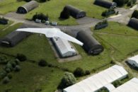
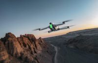
 Swiss manufacturer Xer Technologies presented its Xer X8 hybrid-electric unmanned aircraft system at Intergeo 2025 in Frankfurt, demonstrating the platform’s advanced capabilities for large-scale infrastructure monitoring operations. The Xer X8 addresses critical operational limitations of battery-powered drones through innovative hybrid propulsion technology. Xer X8 Technical Specifications and Performance The Xer X8, (available in an NDAA-compliant… Read more: From the Floor of Intergeo 2025: Xer Showcases Their Hybrid-Electric X8 Infrastructure Inspection Drone
 - Verge Aerospace Reveals New AI Drone Show Tools
 All-in-one drone show system developer Verge Aero recently announced the release of their new AI drone show tool, designed to produce advanced UAV shows from a text prompt. The new functionality, built directly into Verge’s design studio, allows anyone to quickly bring their ideas from concept to flight-ready show in minutes. Key Features Key features… Read more: Verge Aerospace Reveals New AI Drone Show Tools
 - Alpine Eagle Completes Counter-Drone Trials with Ukrainian Armed Forces
 Field Tests Demonstrate Autonomous Air-to-Air C-UAS System in Critical Operational Environment European defence technology company Alpine Eagle has successfully completed trials of its counter-unmanned aircraft system (C-UAS) with the Armed Forces of Ukraine (AFU). The tests, conducted over the summer, showcased the company’s air-to-air counter-drone capabilities in one of the most challenging operational environments in… Read more: Alpine Eagle Completes Counter-Drone Trials with Ukrainian Armed Forces
 - SimActive Enables 3D Calculations from Drone Imagery at Mining Sites
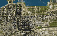
 Correlator3D Software Streamlines Volume Measurements and Terrain Analysis SimActive Inc. has announced that its Correlator3D™ software is being used in Germany to generate volumetric calculations from drone imagery. The technology creates dense point clouds at mining sites, enabling accurate volume measurements and detailed terrain analysis. Improving Mining Operations with Drone Photogrammetry Mining operations often require… Read more: SimActive Enables 3D Calculations from Drone Imagery at Mining Sites
 - From Data to Value: Unlocking ROI in Enterprise Drone Programs from the Floor of Commercial UAV Expo
 Commercial UAV Expo returned to Las Vegas September 2–4, 2025, bringing together industry leaders to discuss the latest trends, technologies, and challenges in the uncrewed systems sector. The event featured a wide range of panels and keynote sessions designed to help operators, enterprises, and government agencies understand how to maximize the value of their drone… Read more: From Data to Value: Unlocking ROI in Enterprise Drone Programs from the Floor of Commercial UAV Expo
 - GeoCue Announces New Street View, Photo Kit for LP360
 Aerial mapping solutions provider GeoCue recently announced the launch of the TrueView GO 360 Photo Kit and the new Street View Navigation in LP360, bringing immersive visualization and intelligent navigation to desktops. LP360’s new Street View mode in Immersive View allows users to navigate through a 360° scene, set a point of view and direction… Read more: GeoCue Announces New Street View, Photo Kit for LP360
 - ACSL Announces New TAITEN Controller, New Thermal Tech via Flir

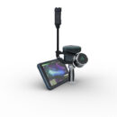
 Japanese drone developer ACSL made several announcements today, including the launch of its new NDAA-compliant smart controller, TAITEN, upgrades to its advanced SAMO thermal camera payload for the SOTEN drone, and official collaboration with Teledyne FLIR’s Thermal by FLIR Program. NEW TAITEN SMART CONTROLLER TAITEN, an NDAA-compliant smart controller, features a high-resolution 7” built-in display… Read more: ACSL Announces New TAITEN Controller, New Thermal Tech via Flir
 - ePropelled Expands U.S. Manufacturing to Meet Rising Demand for Drone Components
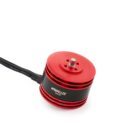 New Hampshire facility set to produce NDAA-compliant propulsion systems as defense demand grows Global propulsion solutions provider ePropelled, Inc. announced a major expansion of its U.S. operations, positioning itself as the first American-based drone component manufacturer with a fully compliant Department of Defense supply chain. The move comes as legislative efforts to limit imports of… Read more: ePropelled Expands U.S. Manufacturing to Meet Rising Demand for Drone Components
 - Antigravity A1 Introduces 8K 360 Capture to the Skies
 New drone offers immersive aerial storytelling with intuitive controls and lightweight design Antigravity A1: A New Way to Experience Drone Flight Antigravity, a consumer drone brand developed by Insta360 and partners, has announced the launch of its first product: the Antigravity A1. The company says it is the world’s first drone to feature 8K 360-degree… Read more: Antigravity A1 Introduces 8K 360 Capture to the Skies
 - This Tiny Polish Drone Launches from a Tube
 DefendEye, a Kraków-based technology company, has developed a tube-launched, fully autonomous drone intended for rapid deployment in a range of operational environments. Weighing under 250 grams, the drone meets sub-250 g regulatory thresholds, which means it can be operated without a pilot’s license in most jurisdictions. The system is aimed at professional users in sectors… Read more: This Tiny Polish Drone Launches from a Tube
 - Managing Multiple Photogrammetry Projects: SimActive Hosts Expert Webinar
 Webinar to Offer Strategies for Streamlining Large-Scale Geospatial Data Processing SimActive Inc., a leading developer of photogrammetry software, will host a live webinar focused on managing multiple large-scale mapping projects at once. The session will take place online and is open to professionals interested in learning how to streamline complex workflows in geospatial production environments.… Read more: Managing Multiple Photogrammetry Projects: SimActive Hosts Expert Webinar
- Skip to main content
- Skip to secondary menu
- Skip to primary sidebar
- Skip to secondary sidebar
- Skip to footer
DRONELIFE
Stay up to date on all the latest Drone News
Footer
SPONSORED


