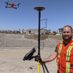
Real-Time Kinematic (RTK) is a buzz term in the UA industry, one many pilots may not understand, even though they may be “mapping” with an uncrewed aircraft (drone). When it comes to RTK and drone mapping, how necessary is the technology to a drone services provider? Will it earn a services provider more money? The following is a guest post by drone industry veteran … [Read more...] about RTK and Drone Mapping: Do You Need It? Is It Worth It?
Featured - Surveying
BVLOS Flight in Canada: Volatus Granted SFOC to Fly Across the Country
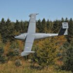
Volatus Aerospace has been granted a Special Flight Operating Certificate (SFOC) to perform BVLOS flight in Canada. Transport Canada has approved Volatus BVLOS ops in six locations across Canada, giving the company the opportunity to demonstrate advance drone operations across the country. Transport Canada is rapidly developing drone regulations: and long distance … [Read more...] about BVLOS Flight in Canada: Volatus Granted SFOC to Fly Across the Country
USC Spatial Sciences Institute Offers the Education You Need to Use Drones in GIS Mapping

The University of Southern California Spatial Sciences Institute offers flexible, online degree and certificate programs that provide the education -and the respected credentials - required to succeed in using drones for GIS mapping. Read on to learn more about how the University of Southern California is helping to shape the way GIS professionals gather data. How GIS … [Read more...] about USC Spatial Sciences Institute Offers the Education You Need to Use Drones in GIS Mapping
Photogrammetry is Evolving: Pix4D Announces Pix4Dmatic
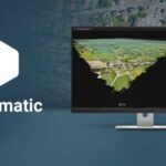
As mapping professionals are called on to map larger and larger areas around the world, photogrammetry software is evolving to meet their needs. Today, Pix4D announces PixDmatic: faster, accurate photogrammetry on a larger scale. "Projects that would have previously been mapped by aircraft are now being surveyed with drones," says a Pix4D press release. "With Pix4Dmatic, … [Read more...] about Photogrammetry is Evolving: Pix4D Announces Pix4Dmatic
Simactive Works to Increase Value in Mining and Surveying Drone Market
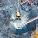
Canadian mapping software company SimActive has added additional capacity to be able to automatically assess multiple volumes of material (aggregates and other material) for projects and to report based upon the findings. If the same area is being flown, users can then compare the volumes and access differences over time. This allows companies to be able to better plan … [Read more...] about Simactive Works to Increase Value in Mining and Surveying Drone Market


