
• Skip to main content
  • Skip to secondary menu
  • Skip to primary sidebar
  • Skip to secondary sidebar
  • Skip to footer
  • DroneRacingLife
  • DroneFlyers
  • Newsletter
DroneLife

DRONELIFE

Stay up to date on all the latest Drone News

  • News
  • Products
  • Industries
    • Agriculture
    • Construction
    • Delivery
    • Dual Use
    • Inspection
    • Public Safety
    • Surveying
  • Enthusiasts
  • Regulations
  • Business
  • Video
  • Podcasts

NASA Advances Drone Technology for 24/7 Wildfire Response

February 5, 2025 by Miriam McNabb Leave a Comment

Testing Portable Airspace Management Systems for Safer, More Effective Aerial Firefighting

NASA is working with the wildfire response community to develop new technologies that will enhance aerial firefighting operations, particularly at night. These advancements could enable drones, both remotely piloted and autonomous, to assist in wildfire suppression around the clock, even in low-visibility conditions.
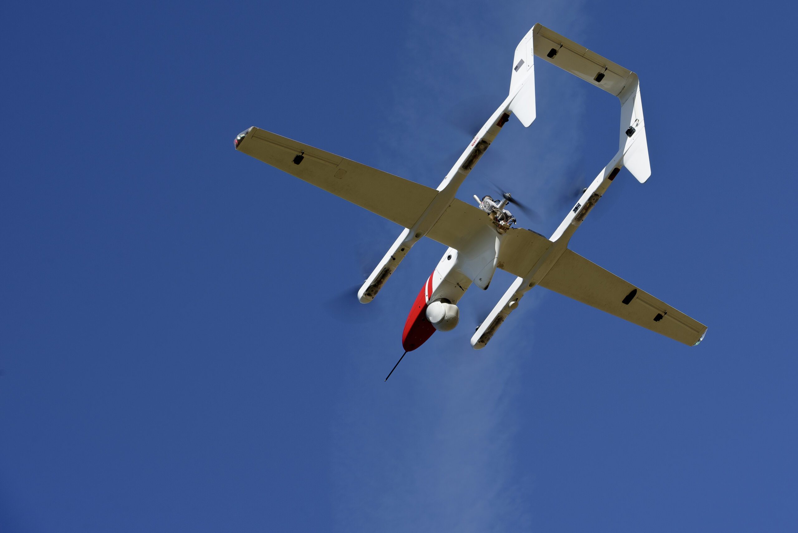
L3Harris FVR90 Unmanned Aerial Vehicle (UAV) lifts off from the Monterey Bay Academy Airport near Watsonville, California, during the Advanced Capabilities for Emergency Response Operations (ACERO) Shakedown.  Image credit: NASA/Don Richey

Enhancing Aerial Firefighting with Autonomous Technologies

Currently, aerial firefighting is limited to daylight hours when pilots have clear visibility. Nighttime operations pose significant risks due to potential collisions with terrain or other aircraft. To address this challenge, NASA has been testing airspace management technologies that allow drones and remotely piloted aircraft to operate safely at night.

In an article posted by NASA, the project manager explains:

“We’re aiming to provide new tools – including airspace management technologies – for 24-hour drone operations for wildfire response,” said Min Xue, project manager of the Advanced Capabilities for Emergency Response Operations (ACERO) project within NASA’s Aeronautics Research Mission Directorate. “This testing will provide valuable data to inform how we mature this technology for eventual use in the field.”

Introducing the Portable Airspace Management System (PAMS)
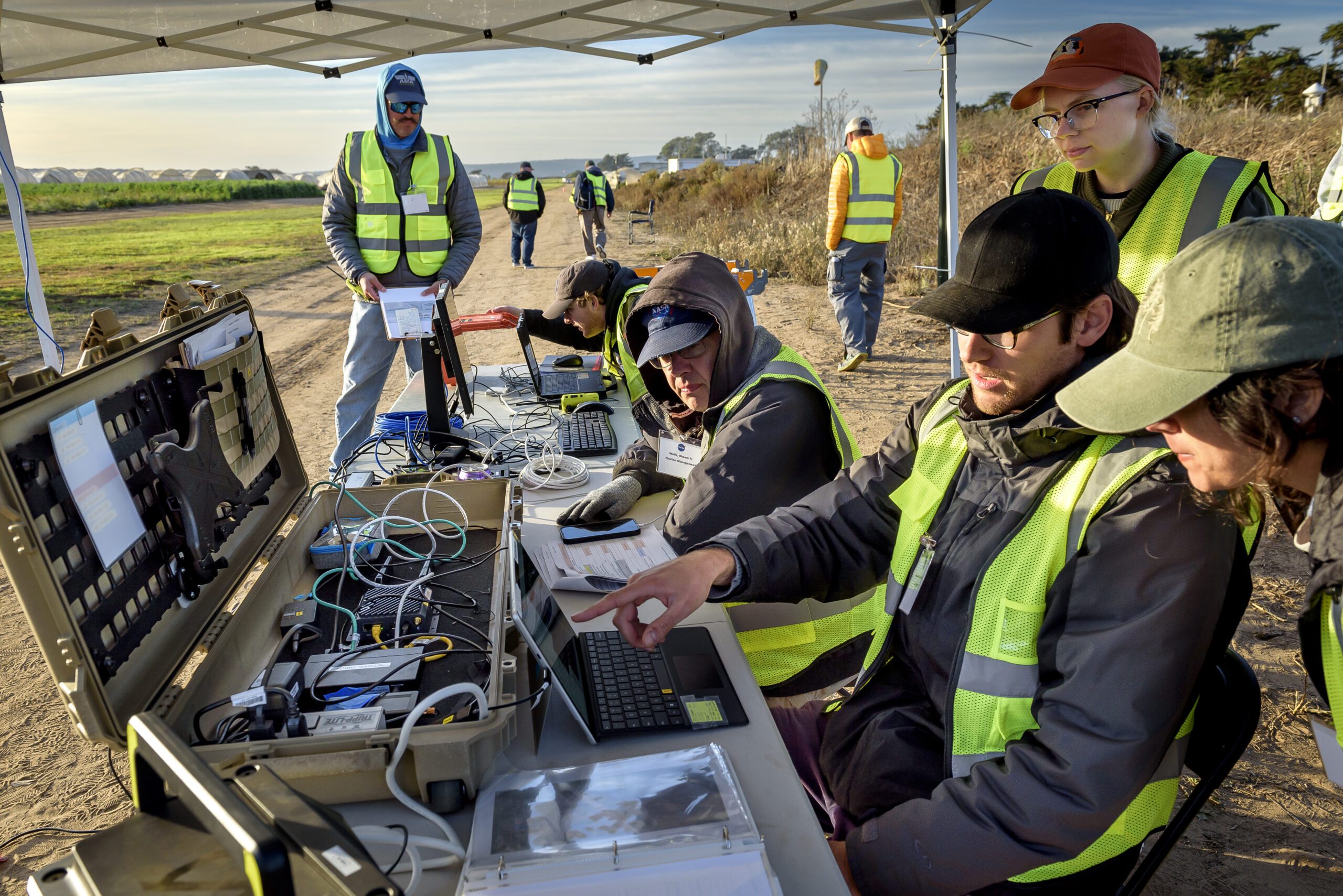
Yasmin Arbab front-right frame, Alexey Munishkin, Shawn Wolfe, with Sarah Mitchell, standing behind, works with the Advanced Capabilities for Emergency Response Operations (ACERO) Portable Airspace Management System (PAMS) case at the Monterey Bay Academy Airport near Watsonville, California. image credit: NASA/Don Richey

Over the past year, ACERO researchers have developed the Portable Airspace Management System (PAMS), designed to help drone pilots safely deploy aircraft for wildfire response. Each PAMS unit, about the size of a carry-on suitcase, is equipped with:

  • A computer for airspace management
  • A radio for communication among PAMS units
  • An Automatic Dependent Surveillance-Broadcast (ADS-B) receiver to track nearby air traffic

These components are housed in a rugged, portable container, making the system easily deployable in the field. The PAMS software helps drone pilots prevent airborne collisions by monitoring and sharing flight plans with other aircraft in the network. Additionally, it provides essential fire location and weather information.

A key feature of the system is an airborne communication relay. A drone equipped with a communication device serves as a relay between ground-based PAMS units, enabling communication without relying on internet connectivity.

Successful Testing at Multiple Locations

To evaluate PAMS’ effectiveness, NASA researchers conducted a series of tests at various locations across the country.

At NASA’s Ames Research Center in California’s Silicon Valley, three PAMS units were placed in different locations outside each other’s line of sight. Researchers entered flight plans into each system and confirmed that the units successfully shared information through a mesh radio network.

The team then expanded testing at NASA’s Langley Research Center in Hampton, Virginia. A long-range vertical takeoff and landing (VTOL) aircraft equipped with a camera, computer, mesh radio, and ADS-B receiver was flown alongside two smaller drones. These tests demonstrated that the mesh radio network aboard the larger drone successfully connected with the small drones and multiple ground-based PAMS units.

Simulating Real-World Firefighting Operations

Further testing took place at Monterey Bay Academy Airport in Watsonville, California, where researchers simulated real-world firefighting scenarios. A winged VTOL drone by Overwatch Aero established a communications relay to three separate PAMS units. Two additional drones were flown nearby, with pilots intentionally submitting conflicting flight plans and operating outside preapproved zones.

The PAMS units successfully detected these conflicts, alerted pilots, and shared real-time aircraft location, weather updates, and simulated fire location data. These results suggest that PAMS can significantly improve aerial coordination during wildfire operations.

“This testing is a significant step towards improving aerial coordination during a wildfire,” Xue said. “These technologies will improve wildfire operations, reduce the impacts of large wildfires, and save more lives.”

Looking Ahead

The ACERO team plans further flight evaluations this year to refine these wildfire technologies. The ultimate goal is to transfer the technology to firefighting agencies to enhance their operational capabilities.

This initiative is part of NASA’s broader efforts under the ACERO project, which operates within the agency’s Aeronautics Research Mission Directorate and supports the Advanced Air Mobility mission.

For more details on NASA’s ACERO project, visit NASA. More information on Overwatch Aero can be found at Overwatch Aero.

Want DRONELIFE news delivered to your inbox every weekday?  Sign up here.

Read more:

  • Drone Technology Supports Wildfire Prevention and Response
  • Autonomous Black Hawk Helicopter Demonstrates Precise Wildfire Suppression
  • New Funding will Help Dryad Networks Develop New Drone-Based System of Early Detection and Swift Suppression for Wildfires

Miriam McNabb

Miriam McNabb is the Editor-in-Chief of DRONELIFE and CEO of JobForDrones, a professional drone services marketplace, and a fascinated observer of the emerging drone industry and the regulatory environment for drones. Miriam has penned over 3,000 articles focused on the commercial drone space and is an international speaker and recognized figure in the industry.  Miriam has a degree from the University of Chicago and over 20 years of experience in high tech sales and marketing for new technologies.
For drone industry consulting or writing, Email Miriam.

TWITTER:@spaldingbarker

Subscribe to DroneLife here.

Filed Under: Drone News, Drone News Feeds, Fire and Police, Firefighter, News, Selected – Safety and Security Tagged With: Advanced Air Mobility, aerial firefighting drones, autonomous wildfire response, drone airspace management, NASA ACERO project, NASA wildfire drone technology, nighttime drone operations, PAMS drone system, UAV firefighting solutions, wildfire suppression technology

Reader Interactions

Leave a Reply Cancel reply

Your email address will not be published. Required fields are marked *

Primary Sidebar

LATEST

The Hard Part May Come After Learning to Fly: Helping Drone Pilots Build a Business

Amy Wiegand’s new AeroRev Co-Pilot aims to address a familiar challenge in the commercial drone industry: turning aviation skills into…

Continue Reading The Hard Part May Come After Learning to Fly: Helping Drone Pilots Build a Business

FCC Keeps September 2 Deadline for Comments on Proposed “Military-Grade” Drone Restrictions

DRONERESPONDERS and the Commercial Drone Alliance sought more time as the FCC considers restrictions covering foreign-produced UAS with thermal imaging,…

Continue Reading FCC Keeps September 2 Deadline for Comments on Proposed “Military-Grade” Drone Restrictions

A2Z Drone Delivery Launches Longtail Dual for BVLOS Urban Missions

The new dual-battery aircraft holds full control on a single battery if one fails, keeps a one-to-one flight-to-charge ratio on…

Continue Reading A2Z Drone Delivery Launches Longtail Dual for BVLOS Urban Missions

Terra Drone Signs DEFTECH for Malaysia Defense Hub and Begins C-UAS System for Critical Infrastructure

Two same-day announcements from Tokyo position Terra Drone across the ASEAN defense market and peacetime infrastructure protection, extending the company’s…

Continue Reading Terra Drone Signs DEFTECH for Malaysia Defense Hub and Begins C-UAS System for Critical Infrastructure

Headed to Commercial UAV Expo 2026? Keynotes, DRONELIFE, and Friends and Partners to Visit in Las Vegas

Commercial UAV Expo returns September 1–3 as major regulatory changes reshape the U.S. drone market. Here’s what the DRONELIFE team…

Continue Reading Headed to Commercial UAV Expo 2026? Keynotes, DRONELIFE, and Friends and Partners to Visit in Las Vegas

Tulsa Hopes to Become ‘The Drone Capital of the World’

By Dronelife Features Editor Jim Magill Tulsa builds a full drone industry ecosystem from the ground up. Tulsa Oklahoma, long…

Continue Reading Tulsa Hopes to Become ‘The Drone Capital of the World’

Robin Radar Opens Northern Virginia Facility as U.S. C-UAS Demand Climbs

The Dutch drone-radar maker adds 20 roles at its new Northern Virginia site, reports 75% growth in U.S. IRIS sales…

Continue Reading Robin Radar Opens Northern Virginia Facility as U.S. C-UAS Demand Climbs

Thales, Kelly Hills Launch BVLOS Drone Network for Kansas Farms

The Kansas Department of Agriculture partner will run crop spraying, scouting, fertilizing and seeding beyond visual line of sight, following…

Continue Reading Thales, Kelly Hills Launch BVLOS Drone Network for Kansas Farms

Japan’s Drone Industry Runs 10-Day Kumamoto Earthquake Response Through JUIDA-D³

This article published in collaboration with JUIDA, the Japan UAS Industrial Development Association.     JUIDA-coordinated teams flew indoor searches at…

Continue Reading Japan’s Drone Industry Runs 10-Day Kumamoto Earthquake Response Through JUIDA-D³

Czech Zuri Introduces Uncrewed Cargo Tiltrotor for Civil and Defense Operations

The Czech aircraft company opens ground testing on Technology Demonstrator 2.0 in Prague and targets flight testing in 2027 and…

Continue Reading Czech Zuri Introduces Uncrewed Cargo Tiltrotor for Civil and Defense Operations

Secondary Sidebar

Footer

SPONSORED

What Is the Best Commercial Cleaning Drone in 2026? Specs, Prices, and a Head-to-Head Comparison

Inspired Flight Gremsy IF800 VIO F1 drones geo week

What Will It Take to Strengthen U.S. Drone Manufacturing? A Conversation with Inspired Flight’s CEO

Global Mapper Mobile data collection

Collection Ground Control Points with Global Mapper Mobile

Military Drone Mapping Solutions

How SimActive’s Correlator3D™ is Revolutionizing Military Mapping: An Exclusive Interview with CEO Philippe Simard

Photogrammetry Accuracy Standards

SimActive Photogrammetry Software: Enabling Users to Meet Accuracy Standards for Over 20 Years

NACT Engineering Parrot ANAFI tether indoor shot

Smart Tether for Parrot ANAFI USA from NACT Engineering

About Us | Contact Us | Advertise With Us | Write for Us | Privacy Policy | Terms of Service

The Trusted Source for the Business of Drones.

This website uses cookies and third party services. By clicking OK, you are agreeing to our privacy policy. ACCEPT

Manage consent

Privacy Overview

This website uses cookies to improve your experience while you navigate through the website. Out of these, the cookies that are categorized as necessary are stored on your browser as they are essential for the working of basic functionalities of the website. We also use third-party cookies that help us analyze and understand how you use this website. These cookies will be stored in your browser only with your consent. You also have the option to opt-out of these cookies. But opting out of some of these cookies may affect your browsing experience.
Necessary
Always Enabled
Necessary cookies are absolutely essential for the website to function properly. These cookies ensure basic functionalities and security features of the website, anonymously.
CookieDurationDescription
cookielawinfo-checkbox-analytics11 monthsThis cookie is set by GDPR Cookie Consent plugin. The cookie is used to store the user consent for the cookies in the category "Analytics".
cookielawinfo-checkbox-functional11 monthsThe cookie is set by GDPR cookie consent to record the user consent for the cookies in the category "Functional".
cookielawinfo-checkbox-necessary11 monthsThis cookie is set by GDPR Cookie Consent plugin. The cookies is used to store the user consent for the cookies in the category "Necessary".
cookielawinfo-checkbox-others11 monthsThis cookie is set by GDPR Cookie Consent plugin. The cookie is used to store the user consent for the cookies in the category "Other.
cookielawinfo-checkbox-performance11 monthsThis cookie is set by GDPR Cookie Consent plugin. The cookie is used to store the user consent for the cookies in the category "Performance".
viewed_cookie_policy11 monthsThe cookie is set by the GDPR Cookie Consent plugin and is used to store whether or not user has consented to the use of cookies. It does not store any personal data.
Functional
Functional cookies help to perform certain functionalities like sharing the content of the website on social media platforms, collect feedbacks, and other third-party features.
Performance
Performance cookies are used to understand and analyze the key performance indexes of the website which helps in delivering a better user experience for the visitors.
Analytics
Analytical cookies are used to understand how visitors interact with the website. These cookies help provide information on metrics the number of visitors, bounce rate, traffic source, etc.
Advertisement
Advertisement cookies are used to provide visitors with relevant ads and marketing campaigns. These cookies track visitors across websites and collect information to provide customized ads.
Others
Other uncategorized cookies are those that are being analyzed and have not been classified into a category as yet.
SAVE & ACCEPT




