
• Skip to main content
  • Skip to secondary menu
  • Skip to primary sidebar
  • Skip to secondary sidebar
  • Skip to footer
  • DroneRacingLife
  • DroneFlyers
  • Newsletter
DroneLife

DRONELIFE

Stay up to date on all the latest Drone News

  • News
  • Products
  • Industries
    • Agriculture
    • Construction
    • Delivery
    • Dual Use
    • Inspection
    • Public Safety
    • Surveying
  • Enthusiasts
  • Regulations
  • Business
  • Video
  • Podcasts

Drone Missions After Hurricane Helene: Sentaero Pilots Deliver Vital Data for Disaster Recovery

October 21, 2024 by Miriam McNabb Leave a Comment

At DRONELIFE, we are honored to be part of the community of drone professionals – a community that invariably rises to the occasion and gets out in the field to help in disaster response.  Here, we are please to present this guest post by Adam Zirkelbach, Marketing Director for Censys Technologies, on their team’s work after Hurricane Helene.  Censys Technologies is a Florida-based manufacturer of endurance fixed wing aircraft.  DRONELIFE neither accepts nor makes payments for guest posts.

Leveraging BVLOS and Advanced Imaging, UAS Crews Aid in Damage Assessment and Resource Allocation Across 500 Miles of Affected Roads

by Adam Zirkelbach

In the wake of Hurricane Helene, the devastation left behind required swift and efficient action to assess damages and coordinate emergency response. To meet this challenge, two Censys Technologies Sentaero 5 Unmanned Aerial Systems (UAS) crews were dispatched to collect crucial data across some of the hardest-hit areas, focusing on key infrastructure like roads. Using advanced drone technology, these teams gathered extensive information on road blockages, asset damage, and debris accumulation, which would become essential in the ongoing recovery efforts.

The use of drones—specifically the Sentaero 5, a fixed-wing vertical take-off and landing (VTOL) drone—enabled the collection of high-quality, comprehensive data over large swathes of land in a short period. This initiative showcased the critical role of UAS in disaster response and recovery.

The Power of UAS Technology in Disaster Response

The Sentaero 5 is a purpose-built platform for these operations due to its unique capabilities that make it particularly suited for large-scale data collection. Equipped with a 61-megapixel camera, the Sentaero 5 was able to capture high-resolution images, providing detailed insights into the damage caused by Hurricane Helene.
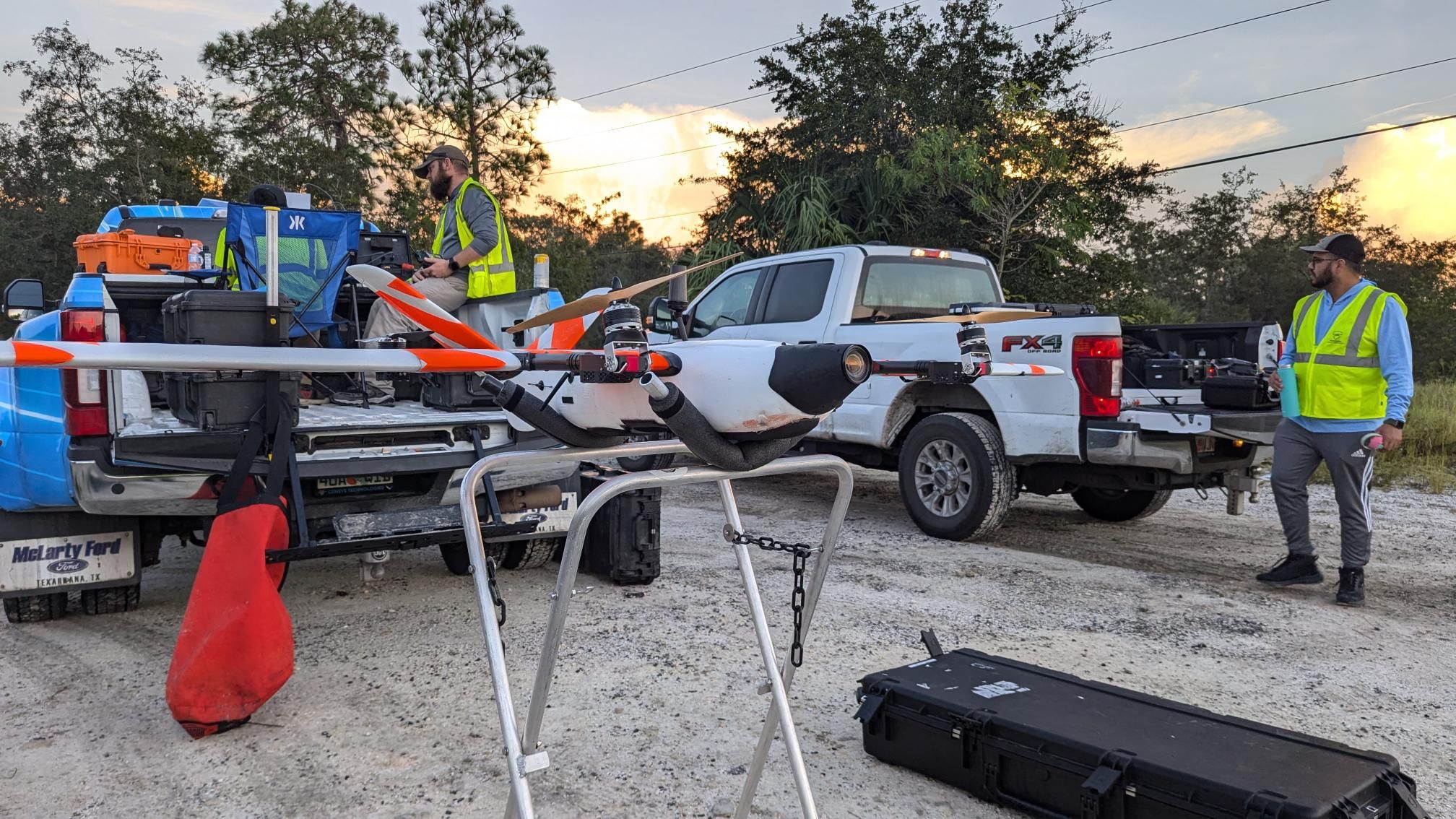
One of the most valuable aspects of the Sentaero 5 is its ability to operate Beyond Visual Line of Sight (BVLOS) and Over-The-Horizon (OTH), which allows the drone to cover significant distances without needing the operator to maintain direct visual contact. This capability makes it ideal for surveying vast areas affected by natural disasters, where rapid assessment is crucial.

What sets the Sentaero 5 apart is its cellular command and control (C2) link, onboard Detect-and-Avoid (DAA) technology, high-level autonomy enabling the aircraft to fly its mission without human input, and robust safety record. By utilizing a cellular network, similar to the one used by standard mobile phones, operators can control the drone with greater range and reliability. Onboard the drone are four SIM cards, which enable it to switch seamlessly between the strongest network connections. This feature is particularly beneficial in disaster zones, where communications infrastructure may be compromised. The cellular link allows for Sentaero operations spanning 10, 15, or even 20 miles out, far exceeding the typical 3-mile range of traditional radio systems. The farthest distance flown in the Helene operations was 28 miles.

Maximizing Efficiency Through Regulatory Support

Critical to the success of these operations were the Special Government Interest (SGI) waivers granted for each flight location. These waivers, provided by the Federal Aviation Administration (FAA), allowed the UAS crews to legally conduct BVLOS operations in areas where normal restrictions might otherwise apply.

Not only did these waivers facilitate the UAS missions, but the FAA also instituted Temporary Flight Restrictions (TFRs) in the affected areas, which provided a safe operational environment by restricting other air traffic. This coordination between regulatory agencies and UAS operators underscores the importance of government support in enabling effective disaster response using drones.

The SGI waivers played a pivotal role in ensuring that the data collection missions could be completed efficiently, safely, and without interference. These measures allowed the response teams to focus on gathering data quickly in areas.

Mission Results: Impact of UAS Data on Recovery Operations

The Sentaero crews were able to capture around 500 miles of roadways between Pine Island and Sanibel Island, including downtown Tampa, in just a few days, showcasing the efficiency of drone-based data collection in post-disaster scenarios. The data collected was instrumental in assessing road blockages, determining the extent of asset damage, and quantifying debris levels.

For instance, the high-resolution imagery captured by the Sentaero 5 provided detailed visuals of blocked roads, damaged infrastructure, and areas requiring immediate attention. This data was shared with response teams and used to optimize the dispatch of crews to clear roads and restore access to affected communities.

By prioritizing areas with the most significant damage or blockages, response teams were able to allocate their resources more effectively, reducing delays in the recovery process. This not only improved the speed of the recovery effort but also ensured that emergency services could reach critical locations faster.

Conclusion

The use of UAS in the response to Hurricane Helene highlights the transformative potential of drone technology in disaster scenarios. With platforms like the Sentaero 5, equipped with quality imaging technology and OTH BVLOS capabilities, teams can gather essential data over large areas in a fraction of the time it would take using traditional methods.

The operations carried out by the UAS crews provided critical information that informed response strategies and ensured that resources were deployed where they were most needed. As disaster response technologies continue to evolve, UAS will undoubtedly play an even larger role in future recovery efforts, proving themselves to be indispensable tools in safeguarding communities.

Read more:

  • Censys Technologies Secures FAA Waiver for Drone Operations Over People and Moving Vehicles
  • Breaking Barriers: Censys Technologies Soars to New Heights with 30-Mile BVLOS Flight Milestone
  • Censys Adds LiDAR Options to Long-Range, BVLOS Fixed Wing

Like what you are reading?  Subscribe to DroneLife!

Adam Zirkelbach is the Marketing Director for Censys Technologies, a leading US-based provider of uncrewed aerial systems, specializing in the development and production of innovative BVLOS drones for various industries. With a focus on advanced technologies and user-centric design, Censys Technologies strives to deliver at the edge solutions that revolutionize the way businesses operate. 

Miriam McNabb

Miriam McNabb is the Editor-in-Chief of DRONELIFE and CEO of JobForDrones, a professional drone services marketplace, and a fascinated observer of the emerging drone industry and the regulatory environment for drones. Miriam has penned over 3,000 articles focused on the commercial drone space and is an international speaker and recognized figure in the industry.  Miriam has a degree from the University of Chicago and over 20 years of experience in high tech sales and marketing for new technologies.
For drone industry consulting or writing, Email Miriam.

TWITTER:@spaldingbarker

Subscribe to DroneLife here.

Filed Under: Applications, Drone News, Drone News Feeds, Drones in the News, News Tagged With: aerial data collection, BVLOS operations, Censys Technologies, Drone Technology, emergency response, FAA waivers, hurricane recovery, road damage assessment, Sentaero drones, UAS disaster response

Reader Interactions

Leave a Reply Cancel reply

Your email address will not be published. Required fields are marked *

Primary Sidebar

LATEST

From Power Lines to Mine Shafts: Lidar Expands the Reach of Drone Mapping

Ouster partnerships with GeoCue and Flyability show how next-generation lidar is supporting applications above infrastructure and deep inside confined spaces…

Continue Reading From Power Lines to Mine Shafts: Lidar Expands the Reach of Drone Mapping

SimActive Adds Interactive Mode to Correlator3D for Faster Photogrammetry Workflows

The new interactive mode runs multiple scripts in a single session, cutting delays between operations for repetitive photogrammetry pipelines. SimActive…

Continue Reading SimActive Adds Interactive Mode to Correlator3D for Faster Photogrammetry Workflows

Texas Senators Call for Drone-Powered “Smart Wall”

By Dronelife Features Editor Jim Magill Facing threats from the federal government to build a border wall or other physical…

Continue Reading Texas Senators Call for Drone-Powered “Smart Wall”

When Drones Generate 6,000 Images, Who Looks at Them? AI’s Real Role in Commercial Drone Operations

Commercial UAV Expo panelists point to data analysis, scale and human oversight as the near-term value of artificial intelligence. As…

Continue Reading When Drones Generate 6,000 Images, Who Looks at Them? AI’s Real Role in Commercial Drone Operations

Bechtel and Cyberhawk Expand Eight-Year Collaboration on AI-Driven Drone Construction Monitoring

The two companies formalize their partnership to scale iHawk drone analytics, autonomous data capture and AI-assisted site analysis on live…

Continue Reading Bechtel and Cyberhawk Expand Eight-Year Collaboration on AI-Driven Drone Construction Monitoring

Powerus Signs $22.3M Counter-UAS Deal With Private Middle East Oil Firm

By Dronelife Features Editor Jim Magill Powerus counter-UAS deal signals a new private sector paradigm. In what might be the…

Continue Reading Powerus Signs $22.3M Counter-UAS Deal With Private Middle East Oil Firm

Robinson’s “Era of Both” Expands from Tactical Drones to Heavy-Lift UAS

Full-size unmanned helicopter demonstrates deck landings and cargo operations as Robinson shows off range: from small tactical drones to heavy-lift…

Continue Reading Robinson’s “Era of Both” Expands from Tactical Drones to Heavy-Lift UAS

TSA Seeks Drone Industry Input on Security Requirements for Part 108 BVLOS Operations

Technical roundtables will examine how existing BVLOS security practices could help operators comply with new requirements For years, the drone…

Continue Reading TSA Seeks Drone Industry Input on Security Requirements for Part 108 BVLOS Operations

FCC “Military-Grade” Drone Proposal Draws Overwhelming Opposition in Public Comments

Pilot Institute analysis finds 98.6% of readable filings opposed the proposed restrictions as writte Review of 3,824 readable filings finds…

Continue Reading FCC “Military-Grade” Drone Proposal Draws Overwhelming Opposition in Public Comments

Open Platform Strategy Offers Flexibility as the U.S. Drone Market Shifts: DRONELIFE Exclusive Interview

Blue UAS manufacturer Inspired Flight sees an open payload ecosystem as a way to extend aircraft value and give operators…

Continue Reading Open Platform Strategy Offers Flexibility as the U.S. Drone Market Shifts: DRONELIFE Exclusive Interview

Secondary Sidebar

Footer

SPONSORED

What Is the Best Commercial Cleaning Drone in 2026? Specs, Prices, and a Head-to-Head Comparison

Inspired Flight Gremsy IF800 VIO F1 drones geo week

What Will It Take to Strengthen U.S. Drone Manufacturing? A Conversation with Inspired Flight’s CEO

Global Mapper Mobile data collection

Collection Ground Control Points with Global Mapper Mobile

Military Drone Mapping Solutions

How SimActive’s Correlator3D™ is Revolutionizing Military Mapping: An Exclusive Interview with CEO Philippe Simard

Photogrammetry Accuracy Standards

SimActive Photogrammetry Software: Enabling Users to Meet Accuracy Standards for Over 20 Years

NACT Engineering Parrot ANAFI tether indoor shot

Smart Tether for Parrot ANAFI USA from NACT Engineering

About Us | Contact Us | Advertise With Us | Write for Us | Privacy Policy | Terms of Service

The Trusted Source for the Business of Drones.

This website uses cookies and third party services. By clicking OK, you are agreeing to our privacy policy. ACCEPT

Manage consent

Privacy Overview

This website uses cookies to improve your experience while you navigate through the website. Out of these, the cookies that are categorized as necessary are stored on your browser as they are essential for the working of basic functionalities of the website. We also use third-party cookies that help us analyze and understand how you use this website. These cookies will be stored in your browser only with your consent. You also have the option to opt-out of these cookies. But opting out of some of these cookies may affect your browsing experience.
Necessary
Always Enabled
Necessary cookies are absolutely essential for the website to function properly. These cookies ensure basic functionalities and security features of the website, anonymously.
CookieDurationDescription
cookielawinfo-checkbox-analytics11 monthsThis cookie is set by GDPR Cookie Consent plugin. The cookie is used to store the user consent for the cookies in the category "Analytics".
cookielawinfo-checkbox-functional11 monthsThe cookie is set by GDPR cookie consent to record the user consent for the cookies in the category "Functional".
cookielawinfo-checkbox-necessary11 monthsThis cookie is set by GDPR Cookie Consent plugin. The cookies is used to store the user consent for the cookies in the category "Necessary".
cookielawinfo-checkbox-others11 monthsThis cookie is set by GDPR Cookie Consent plugin. The cookie is used to store the user consent for the cookies in the category "Other.
cookielawinfo-checkbox-performance11 monthsThis cookie is set by GDPR Cookie Consent plugin. The cookie is used to store the user consent for the cookies in the category "Performance".
viewed_cookie_policy11 monthsThe cookie is set by the GDPR Cookie Consent plugin and is used to store whether or not user has consented to the use of cookies. It does not store any personal data.
Functional
Functional cookies help to perform certain functionalities like sharing the content of the website on social media platforms, collect feedbacks, and other third-party features.
Performance
Performance cookies are used to understand and analyze the key performance indexes of the website which helps in delivering a better user experience for the visitors.
Analytics
Analytical cookies are used to understand how visitors interact with the website. These cookies help provide information on metrics the number of visitors, bounce rate, traffic source, etc.
Advertisement
Advertisement cookies are used to provide visitors with relevant ads and marketing campaigns. These cookies track visitors across websites and collect information to provide customized ads.
Others
Other uncategorized cookies are those that are being analyzed and have not been classified into a category as yet.
SAVE & ACCEPT




