Pilot program combines aerial LiDAR and construction scheduling to provide more accurate progress tracking and improve safety on major transportation infrastructure
As construction continues on the final phase of North Carolina’s Complete 540 project, the North Carolina Turnpike Authority (NCTA) is using drone-based LiDAR to gain a more detailed view of construction progress while reducing the need for personnel to work in active construction zones.
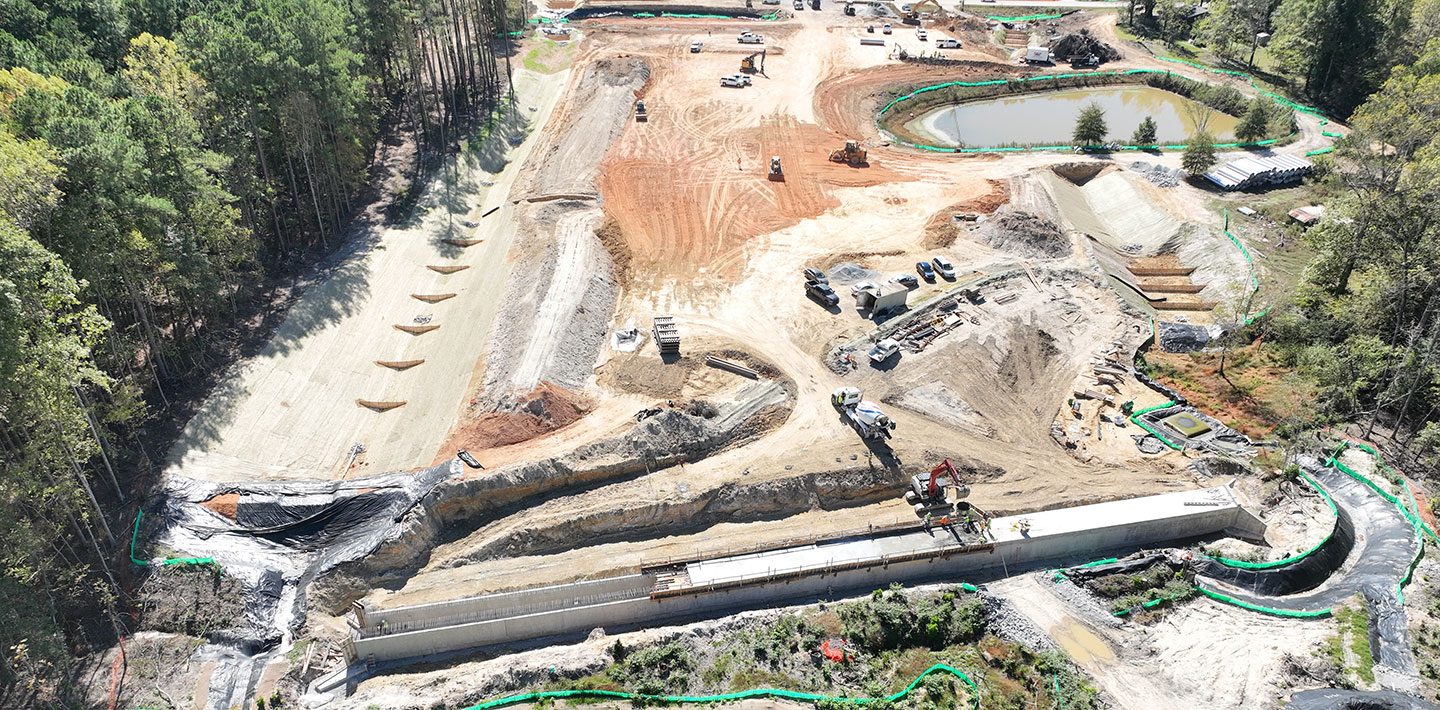
The initiative, implemented in January 2026 in partnership with engineering firm WSP, combines monthly drone-based LiDAR surveys with cost-loaded Critical Path Method (CPM) scheduling. The approach is designed to give project managers a more accurate understanding of construction progress than traditional surveying methods alone.
The work supports Phase 2 of Complete 540, a 10-mile extension of the Triangle Expressway that will complete the Interstate 540 loop around the greater Raleigh area. The project is expected to open in late 2028 and is intended to improve mobility and reduce congestion throughout North Carolina’s fast-growing Research Triangle region.
Combining Aerial Data with Project Scheduling
Traditional construction monitoring relies on field surveys and manual progress tracking. On large infrastructure projects, those methods can require survey crews to spend significant time in active construction areas while collecting data that may take weeks to process.
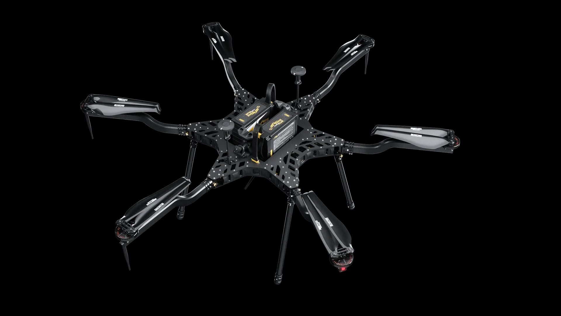
To streamline that process, WSP conducts monthly drone flights over the construction corridor using a Harris Aerial Carrier H6E equipped with a RIEGL LiDAR sensor. The resulting datasets are processed through the Propeller cloud platform, allowing engineers and project managers to review high-resolution terrain models and compare existing conditions with design plans.
The integration of LiDAR data with cost-loaded CPM schedules distinguishes the pilot from a standard aerial surveying program. By connecting measured quantities and observed field conditions with scheduled construction activities, the project team can better evaluate completed work, remaining quantities, and overall project status.
The combined workflow provides a more data-driven picture of progress and can help identify potential schedule issues earlier in the construction process.
Improving Efficiency and Safety
According to WSP, using drone-based LiDAR significantly reduces the amount of time required for field data collection compared with conventional surveying techniques.
The technology also captures detailed topographic information across large portions of the corridor during a single flight, improving the consistency of quantity measurements and progress verification.
Reducing the number of personnel required to work near heavy equipment and active traffic is another benefit. With much of the data collected remotely, survey teams spend less time in potentially hazardous environments while still providing project managers with frequent updates.
The approach is intended to support several objectives:
- Reduce field time and accelerate data collection.
- Improve the accuracy of quantity tracking and construction progress verification.
- Increase worker safety by limiting time spent in active work zones.
- Provide clearer visibility into project status through integrated scheduling and measurement data.
Early results from the pilot have been viewed positively by NCTA, reinforcing the value of combining drone-based data collection with construction scheduling on large transportation projects.
A Model for Future Infrastructure Programs
Complete 540 represents one of North Carolina’s largest ongoing transportation investments. When complete, the final extension of the Triangle Expressway will create a continuous loop around the Raleigh metropolitan area, improving regional connectivity and supporting continued economic growth.
Beyond the highway itself, the project also demonstrates how drone technology is becoming part of modern infrastructure management rather than serving only as a surveying tool.
As transportation agencies face increasing pressure to deliver complex projects more efficiently, integrating drone-based LiDAR with project scheduling offers a scalable approach to construction oversight. Frequent aerial data collection, combined with digital project management tools, can provide owners with more timely information while improving safety and supporting more informed decisions throughout construction.
For agencies managing large transportation programs, Complete 540 illustrates how drones, LiDAR, and cloud-based analytics can work together to provide a more complete picture of project performance from groundbreaking through completion.
Read more:
- Drones Aid Disaster Recovery: Mapping and Photogrammetry Support Hurricane Helene Relief Efforts
- NC DOT to Deploy Remote Drone Operations at Construction Sites: the Path to Routine, BVLOS Inspections
- SimActive Software Supports Highway Ramp Expansion Through Integrated Lidar and Photogrammetry

Miriam McNabb is the Editor-in-Chief of DRONELIFE and CEO of JobForDrones, a professional drone services marketplace, and a fascinated observer of the emerging drone industry and the regulatory environment for drones. Miriam has penned over 3,000 articles focused on the commercial drone space and is an international speaker and recognized figure in the industry. Miriam has a degree from the University of Chicago and over 20 years of experience in high tech sales and marketing for new technologies.
For drone industry consulting or writing, Email Miriam.
TWITTER:@spaldingbarker
Subscribe to DroneLife here.


Leave a Reply