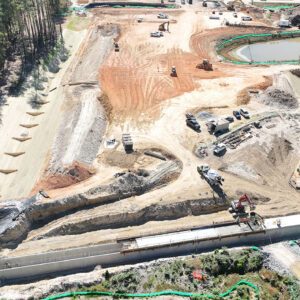
Pilot program combines aerial LiDAR and construction scheduling to provide more accurate progress tracking and improve safety on major transportation infrastructure As construction continues on the final phase of North Carolina's Complete 540 project, the North Carolina Turnpike Authority (NCTA) is using drone-based LiDAR to gain a more detailed view of construction progress … [Read more...] about North Carolina Turnpike Authority Uses Drone LiDAR to Improve Oversight on Complete 540 Project
civil engineering
Quick Start Guide to Drones in Public Infrastructure

Skylogic Research, the leading research and advisory services firm for the commercial drone industry and owner of Drone Analyst®, announced today the release of their Quick Start Guide to Drones in Public Infrastructure. This report is the third in a new series of Skylogic Research white papers, intended to provide a complete primer to drone use in specific industries. The … [Read more...] about Quick Start Guide to Drones in Public Infrastructure


