• Skip to main content
  • Skip to secondary menu
  • Skip to primary sidebar
  • Skip to secondary sidebar
  • Skip to footer
  • DroneRacingLife
  • DroneFlyers
  • Newsletter
DroneLife

DRONELIFE

Stay up to date on all the latest Drone News

  • News
  • Products
  • Industries
    • Agriculture
    • Construction
    • Delivery
    • Dual Use
    • Inspection
    • Public Safety
    • Surveying
  • Enthusiasts
  • Regulations
  • Business
  • Video
  • Podcasts

DroneDeploy Offers Free Software for Hurricane Relief

September 2, 2021 by Miriam McNabb 8 Comments

DroneDeploy offers free software for hurricane reliefDrone mapping platform DroneDeploy offers free software for hurricane relief.

by DRONELIFE Staff Writer Ian Crosby

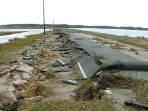
DroneDeploy has announced that it will be providing free software access to any organization or government agency involved in conducting drone-powered response efforts in the areas impacted by the ongoing disaster caused by Hurricane Ida. With the stated mission of making drone data more accessible and available for everyone, the California based company is responsible for the leading cloud software program for commercial drones. Their software is used in more than 180 countries worldwide, and their customers have mapped 200 million acres.

DroneDeploy is no stranger to offering assistance to disaster response teams. The company has plenty of previous experience supporting disaster relief efforts with advanced mapping, post-disaster inspections, and incident reporting via drone, proving particularly helpful in dealing with difficult to reach and unsafe areas. In 2020, the company’s nonprofit branch partnered with Disaster Relief Australia, providing the organization with access to aerial imagery capture technology. In the year prior, their aerial mapping software was utilized in disaster response and damage assessment efforts following the deadly Camp Fire in California. The company’s nonprofit branch has partnered with more than 200 universities, as well as over 80 nonprofit organizations.

The organizations and agencies that are granted access for the ongoing disaster response effort will be able to make use of DroneDeploy’s enterprise cloud-processing platform. In addition, these users will receive priority support from the company’s crisis response and technical support teams.

More information as to how organizations looking to participate can gain access to the software program can be found here.

Ian attended Dominican University of California, where he received a BA in English in 2019. With a lifelong passion for writing and storytelling and a keen interest in technology, he is now contributing to DroneLife as a staff writer.


Miriam McNabb

Miriam McNabb is the Editor-in-Chief of DRONELIFE and CEO of JobForDrones, a professional drone services marketplace, and a fascinated observer of the emerging drone industry and the regulatory environment for drones. Miriam has penned over 3,000 articles focused on the commercial drone space and is an international speaker and recognized figure in the industry.  Miriam has a degree from the University of Chicago and over 20 years of experience in high tech sales and marketing for new technologies.
For drone industry consulting or writing, Email Miriam.

TWITTER:@spaldingbarker

Subscribe to DroneLife here.

Filed Under: Drone News Feeds, News Tagged With: drone in disaster response, drone mapping, DroneDeploy, hurricane damage

Reader Interactions

Trackbacks

  1. DroneDeploy Gives Free Software program for Hurricane Reduction – Get Best Drone says:
    December 7, 2022 at 7:24 am

    […] [ad_2] Source link […]

    Reply
  2. DroneDeploy Offers Free Software for Hurricane Relief – Game Up News says:
    September 2, 2021 at 8:41 pm

    […] Source link […]

    Reply
  3. DroneDeploy Offers Free Software for Hurricane Relief - DronesOnline.site says:
    September 2, 2021 at 5:15 pm

    […] post DroneDeploy Offers Free Software for Hurricane Relief appeared first on […]

    Reply
  4. DroneDeploy Offers Free Software for Hurricane Relief – Drone Observer says:
    September 2, 2021 at 4:40 pm

    […] Source link […]

    Reply
  5. DroneDeploy Offers Free Software for Hurricane Relief – Dronestagram Blog says:
    September 2, 2021 at 4:18 pm

    […] More… […]

    Reply
  6. DroneDeploy Offers Free Software for Hurricane Relief - Buy Fly Drones says:
    September 2, 2021 at 4:00 pm

    […] Source link […]

    Reply
  7. DroneDeploy Offers Free Software for Hurricane Relief – DronePilots.News says:
    September 2, 2021 at 3:24 pm

    […] post DroneDeploy Offers Free Software for Hurricane Relief appeared first on […]

    Reply
  8. DroneDeploy Offers Free Software for Hurricane Relief | Drone Films Limited says:
    September 2, 2021 at 3:18 pm

    […] post DroneDeploy Offers Free Software for Hurricane Relief appeared first on […]

    Reply

Leave a Reply Cancel reply

Your email address will not be published. Required fields are marked *

Primary Sidebar

LATEST

University of Tokyo and Kubota Develop Drone Potato Yield Prediction Method

This article published in collaboration with JUIDA, the Japan UAS Industrial Development Association.     Researchers at the University of Tokyo…

Continue Reading University of Tokyo and Kubota Develop Drone Potato Yield Prediction Method

Department of War Creates Central Office to Oversee U.S. Military Unmanned Systems

New Direct Reporting Portfolio Manager will consolidate acquisition, standards, budgeting, and industry engagement for drone and autonomous programs The U.S.…

Continue Reading Department of War Creates Central Office to Oversee U.S. Military Unmanned Systems

FAA Investigating Reported Drone Encounter on JetBlue Flight Approaching JFK

The Federal Aviation Administration (FAA) is investigating after the crew of a JetBlue flight reported striking what they believed was…

Continue Reading FAA Investigating Reported Drone Encounter on JetBlue Flight Approaching JFK

Versaterm on the Drone Radio Show! Next Level Integration of Drones into Public Safety

Versaterm on the Drone Radio Show! In this episode, Ryan Bracken explains how Versaterm’s acquisition of DroneSense is helping agencies…

Continue Reading Versaterm on the Drone Radio Show! Next Level Integration of Drones into Public Safety

ANRA Technologies Surpasses 55,000 Commercial Drone Operations Per Month

ANRA says its Mission Manager X platform now supports more than 1,800 BVLOS commercial drone operations per day across delivery,…

Continue Reading ANRA Technologies Surpasses 55,000 Commercial Drone Operations Per Month

Nearly One Million Comments Underscore Stakes of FAA’s Section 2209 Rule

Experts weigh in on extension of 2209 comment period By DRONELIFE Features Editor Jim Magill With almost 1 million comments…

Continue Reading Nearly One Million Comments Underscore Stakes of FAA’s Section 2209 Rule

ND UAS Council Adds Grand Forks DDA to Strengthen Drone Ecosystem

The North Dakota UAS Council has added the Grand Forks Downtown Development Association as its newest member, linking the state’s…

Continue Reading ND UAS Council Adds Grand Forks DDA to Strengthen Drone Ecosystem

World-First Drone Mouse Eradication Passes Six-Month Check on Browse Island

Parks and Wildlife Service staff have returned to Browse Island Nature Reserve for a follow-up survey and found no signs…

Continue Reading World-First Drone Mouse Eradication Passes Six-Month Check on Browse Island

House FY27 NDAA Signals Drones Have Become Core Military Infrastructure

Rather than focusing primarily on buying new drones, the House Armed Services Committee is proposing the standards, training, doctrine, and…

Continue Reading House FY27 NDAA Signals Drones Have Become Core Military Infrastructure

Don’t Miss AirWise Solutions on the Public Safety Drone Review, July 7!

Join us Tuesday, July 7 at 3pm EST for the next edition of the Public Safety Drone Review, presented by…

Continue Reading Don’t Miss AirWise Solutions on the Public Safety Drone Review, July 7!

Secondary Sidebar

Footer

SPONSORED

Inspired Flight Gremsy IF800 VIO F1 drones geo week

What Will It Take to Strengthen U.S. Drone Manufacturing? A Conversation with Inspired Flight’s CEO

Global Mapper Mobile data collection

Collection Ground Control Points with Global Mapper Mobile

Military Drone Mapping Solutions

How SimActive’s Correlator3D™ is Revolutionizing Military Mapping: An Exclusive Interview with CEO Philippe Simard

Photogrammetry Accuracy Standards

SimActive Photogrammetry Software: Enabling Users to Meet Accuracy Standards for Over 20 Years

NACT Engineering Parrot ANAFI tether indoor shot

Smart Tether for Parrot ANAFI USA from NACT Engineering

Blue Marble, features global mapper, features Blue Marble

Check Out These New Features in Global Mapper v25 from Blue Marble

About Us | Contact Us | Advertise With Us | Write for Us | Privacy Policy | Terms of Service

The Trusted Source for the Business of Drones.

This website uses cookies and third party services. By clicking OK, you are agreeing to our privacy policy. ACCEPT

Manage consent

Privacy Overview

This website uses cookies to improve your experience while you navigate through the website. Out of these, the cookies that are categorized as necessary are stored on your browser as they are essential for the working of basic functionalities of the website. We also use third-party cookies that help us analyze and understand how you use this website. These cookies will be stored in your browser only with your consent. You also have the option to opt-out of these cookies. But opting out of some of these cookies may affect your browsing experience.
Necessary
Always Enabled
Necessary cookies are absolutely essential for the website to function properly. These cookies ensure basic functionalities and security features of the website, anonymously.
CookieDurationDescription
cookielawinfo-checkbox-analytics11 monthsThis cookie is set by GDPR Cookie Consent plugin. The cookie is used to store the user consent for the cookies in the category "Analytics".
cookielawinfo-checkbox-functional11 monthsThe cookie is set by GDPR cookie consent to record the user consent for the cookies in the category "Functional".
cookielawinfo-checkbox-necessary11 monthsThis cookie is set by GDPR Cookie Consent plugin. The cookies is used to store the user consent for the cookies in the category "Necessary".
cookielawinfo-checkbox-others11 monthsThis cookie is set by GDPR Cookie Consent plugin. The cookie is used to store the user consent for the cookies in the category "Other.
cookielawinfo-checkbox-performance11 monthsThis cookie is set by GDPR Cookie Consent plugin. The cookie is used to store the user consent for the cookies in the category "Performance".
viewed_cookie_policy11 monthsThe cookie is set by the GDPR Cookie Consent plugin and is used to store whether or not user has consented to the use of cookies. It does not store any personal data.
Functional
Functional cookies help to perform certain functionalities like sharing the content of the website on social media platforms, collect feedbacks, and other third-party features.
Performance
Performance cookies are used to understand and analyze the key performance indexes of the website which helps in delivering a better user experience for the visitors.
Analytics
Analytical cookies are used to understand how visitors interact with the website. These cookies help provide information on metrics the number of visitors, bounce rate, traffic source, etc.
Advertisement
Advertisement cookies are used to provide visitors with relevant ads and marketing campaigns. These cookies track visitors across websites and collect information to provide customized ads.
Others
Other uncategorized cookies are those that are being analyzed and have not been classified into a category as yet.
SAVE & ACCEPT