• Skip to main content
  • Skip to secondary menu
  • Skip to primary sidebar
  • Skip to secondary sidebar
  • Skip to footer
  • DroneRacingLife
  • DroneFlyers
  • Newsletter
DroneLife

DRONELIFE

Stay up to date on all the latest Drone News

  • News
  • Products
  • Industries
    • Agriculture
    • Construction
    • Delivery
    • Dual Use
    • Inspection
    • Public Safety
    • Surveying
  • Enthusiasts
  • Regulations
  • Business
  • Video
  • Podcasts

Terra For Drone Software Vendors as DJI Launches Mapping & Modeling Tool

March 28, 2019 by Malek Murison 9 Comments

Not that many years ago, DJI was credited with forcing several competitors to pivot out of the drone hardware market and into commercial software.

The Chinese company’s drones were too good and too cheap for the likes of 3DR to compete with.

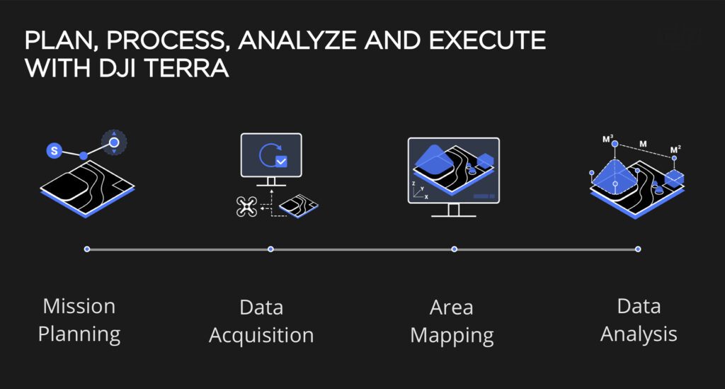
Now the world’s leading manufacturer has launched Terra, a new software tool that transforms drone data into 3D models and maps for analysis and decision making. While it’s obviously early days in DJI’s step into drone data, it’s no doubt a sign of what’s to come.

dji terra

DJI’s end to end plan for data capture, visualization and analysis

DJI’s plan for Terra is simple: to provide a software service where previously the company’s customers would have relied on partners elsewhere. Terra will give businesses and organisations using DJI drones the ability to capture, visualise and analyze aerial images for a wide variety of applications, from public safety and construction to infrastructure, agriculture and more.

“As the leader in the commercial drone industry, DJI continues to develop accessible and easy-to-use hardware and software solutions that help organisations transform their operations with drone technology and gain a competitive advantage in their industries,” said Sunny Liao, Director of Enterprise at DJI.

“As an all-in-one mapping and modelling solution, DJI Terra makes it simple and efficient to extract value from drone data, generating conclusions and recommendations across multiple use cases from crash reconstructions to critical infrastructure inspections as well as agriculture field mapping and construction site modelling.”

Combining Flight Planning With Data Capture

DJI Terra has three mission options depending on the task at hand:

  • Area – Capture a specific area quickly and easily by drawing a custom polygonal flight zone on a map. DJI Terra automatically generates efficient flight path options based on the area selected.
  • Waypoint – Create dynamic custom flight paths through an area or around objects using waypoints and adjustable parameters like aircraft altitude, speed, heading, gimbal pitch and angle. For more complex missions that require high attention to detail, the 3D Flight Visualisation feature enables the design and simulation of missions on existing 3D models.
  • Oblique – Capture a rich data set by automatically flying the same route multiple times. Each flight automatically adjusts the angle of the camera to capture new details, giving an extra crisp 3D model of the object or asset from multiple angles.
dji terra

DJI Terra puts orthomosaic maps at your fingertips

DJI Terra allows drone pilots to generate 2D orthomosaic maps in real time, which is ideal for time-sensitive missions where situational awareness is critical and decisions need to be made in minutes.

DJI Terra’s creates representations of any environment through detailed 2D orthomosaics and 3D model reconstructions, which can be used across a range of industrial applications, including reconstructing vehicle crashes, tracking progress on construction projects, and conducting large-scale critical infrastructure inspections.

In addition to map and model creation, DJI Terra generates instant insights to provide a variety of measurements including linear distance, surface area and volumetric estimations. There are also elements designed to improve team communication and reporting, such as flexible annotation labels and a photo inspection tool which lets users closely examine every photo used to create the model so to highlight critical elements.

DJI Terra Availability

DJI Terra is available today for purchase through authorised DJI Enterprise resellers worldwide. The software is compatible with Windows PCs and all current DJI Phantom 4 Series drones.

Malek Murison
Malek Murison

Malek Murison is a freelance writer and editor with a passion for tech trends and innovation. He handles product reviews, major releases and keeps an eye on the enthusiast market for DroneLife.
Email Malek
Twitter:@malekmurison

Subscribe to DroneLife here.

Filed Under: Business and Finance, Featured, Featured - Business, Imaging Tagged With: commercial drone software., DJI, dji terra, drone data, modeling, Surveying

Reader Interactions

Trackbacks

  1. DJI Expands Mapping & Surveying Solutions | Drone News says:
    September 21, 2019 at 5:32 am

    […] Read more: Terra For Drone Software Vendors as DJI Launches Mapping & Modeling Tool […]

    Reply
  2. DJI Expands Mapping & Surveying Solutions - Angle News says:
    September 17, 2019 at 7:01 am

    […] Read extra: Terra For Drone Software Vendors as DJI Launches Mapping & Modeling Tool […]

    Reply
  3. No Major Releases from DJI in 2019? Why a Consumer Drone Slowdown Was Inevitable - Air Drone Camera says:
    June 24, 2019 at 8:50 am

    […] Mavic 2 Enterprise Dual, the Smart Controller, improved fleet management software, Manifold 2, DJI Terra and more. There’s plenty going […]

    Reply
  4. No Major Releases from DJI in 2019? Why a Consumer Drone Slo... – UAV - THATDRONENEWS.COM says:
    June 22, 2019 at 6:30 am

    […] the Mavic 2 Enterprise Dual, the Smart Controller, improved fleet management software, Manifold 2, DJI Terra and more. There’s plenty going […]

    Reply
  5. No Major Releases from DJI in 2019? Why a Consumer Drone Slowdown Was Inevitable - Angle News says:
    June 21, 2019 at 12:28 pm

    […] the Mavic 2 Enterprise Dual, the Smart Controller, improved fleet management software, Manifold 2, DJI Terra and more. There’s plenty going […]

    Reply
  6. Terra For Drone Software Vendors as DJI Launches Mapping & Modeling Tool says:
    March 28, 2019 at 9:34 pm

    […] post Terra For Drone Software Vendors as DJI Launches Mapping & Modeling Tool appeared first on […]

    Reply
  7. Terra For Drone Software Vendors as DJI Launches Mapping & Modeling Tool - Drones Crunch says:
    March 28, 2019 at 6:31 pm

    […] DRONELIFE […]

    Reply
  8. Terra For Drone Software Vendors as DJI Launches Mapping & Modeling Tool | Apis Insights says:
    March 28, 2019 at 3:49 pm

    […] Click here to view original web page at dronelife.com […]

    Reply
  9. Terra For Drone Software Vendors as DJI Launches Mapping & Modeling Tool | Drone Magazine says:
    March 28, 2019 at 1:25 pm

    […] Source […]

    Reply

Leave a Reply Cancel reply

Your email address will not be published. Required fields are marked *

Primary Sidebar

LATEST

Robodex and Tokyu Land Open Japan’s First Hydrogen Drone Port in Hiroshima

This article published in collaboration with JUIDA, the Japan UAS Industrial Development Association.     Robodex and Tokyu Land Corporation are…

Continue Reading Robodex and Tokyu Land Open Japan’s First Hydrogen Drone Port in Hiroshima

Designed to Fly Like a Falcon, RoBird Takes Aim at Crop-Damaging Birds

From Airports to Agriculture: RoBird Finds New Role Protecting Crops Flapping-wing drone technology expands from bird-strike prevention to agricultural crop…

Continue Reading Designed to Fly Like a Falcon, RoBird Takes Aim at Crop-Damaging Birds

DHS Secretary: U.S. Still Building Counter-Drone Defenses for World Cup

Mullin says feds still ‘a little behind’ in counter-UAS prep By DRONELIFE Features Editor Jim Magill (Editor’s note: This story…

Continue Reading DHS Secretary: U.S. Still Building Counter-Drone Defenses for World Cup

Ondas Unveils New Autonomous Counter-Drone and Robotic Combat Systems

MODUS and IRON WAVE aim to help military forces counter drone threats and deploy robotic systems ahead of frontline troop…

Continue Reading Ondas Unveils New Autonomous Counter-Drone and Robotic Combat Systems

Congress Introduces GUARD Act, Extending FCC Covered List Framework to Robotics

Proposed legislation would require national security review of certain foreign-made humanoid and quadruped robots A bipartisan group of lawmakers has…

Continue Reading Congress Introduces GUARD Act, Extending FCC Covered List Framework to Robotics

Blueflite Added to FAA Section 44807 Approved UAS List: Why it Matters

Cargo drone platform joins FAA-reviewed aircraft list, potentially streamlining future operator approvals Michigan-based drone manufacturer blueflite announced that its Cobalt…

Continue Reading Blueflite Added to FAA Section 44807 Approved UAS List: Why it Matters

Aeronext Unveils ActiveWing Logistics Drone Prototype for Long-Range Delivery

This article published in collaboration with JUIDA, the Japan UAS Industrial Development Association.     The Tokyo company’s new multicopter pairs…

Continue Reading Aeronext Unveils ActiveWing Logistics Drone Prototype for Long-Range Delivery

FBI, Atlanta PD Stress Need for ‘No-Drone Zone’ Compliance

By Dronelife Features Editor Jim Magill (Editor’s note: This story is part of a series of reports on efforts to…

Continue Reading FBI, Atlanta PD Stress Need for ‘No-Drone Zone’ Compliance

Building a Resilient Supply Chain: Regional Security Leaders Focus on Industrial Readiness

Northeast National Security Conference examines how the U.S. can strengthen its defense industrial base Supply chain security has become a…

Continue Reading Building a Resilient Supply Chain: Regional Security Leaders Focus on Industrial Readiness

Defense Leaders Call for Faster Paths from Innovation to the Field

Remarks at the Northeast National Security Conference highlight growing demand for rapid, commercially informed defense solutions The 2026 Northeast National…

Continue Reading Defense Leaders Call for Faster Paths from Innovation to the Field

Secondary Sidebar

Footer

SPONSORED

Inspired Flight Gremsy IF800 VIO F1 drones geo week

What Will It Take to Strengthen U.S. Drone Manufacturing? A Conversation with Inspired Flight’s CEO

Global Mapper Mobile data collection

Collection Ground Control Points with Global Mapper Mobile

Military Drone Mapping Solutions

How SimActive’s Correlator3D™ is Revolutionizing Military Mapping: An Exclusive Interview with CEO Philippe Simard

Photogrammetry Accuracy Standards

SimActive Photogrammetry Software: Enabling Users to Meet Accuracy Standards for Over 20 Years

NACT Engineering Parrot ANAFI tether indoor shot

Smart Tether for Parrot ANAFI USA from NACT Engineering

Blue Marble, features global mapper, features Blue Marble

Check Out These New Features in Global Mapper v25 from Blue Marble

About Us | Contact Us | Advertise With Us | Write for Us | Privacy Policy | Terms of Service

The Trusted Source for the Business of Drones.

This website uses cookies and third party services. By clicking OK, you are agreeing to our privacy policy. ACCEPT

Manage consent

Privacy Overview

This website uses cookies to improve your experience while you navigate through the website. Out of these, the cookies that are categorized as necessary are stored on your browser as they are essential for the working of basic functionalities of the website. We also use third-party cookies that help us analyze and understand how you use this website. These cookies will be stored in your browser only with your consent. You also have the option to opt-out of these cookies. But opting out of some of these cookies may affect your browsing experience.
Necessary
Always Enabled
Necessary cookies are absolutely essential for the website to function properly. These cookies ensure basic functionalities and security features of the website, anonymously.
CookieDurationDescription
cookielawinfo-checkbox-analytics11 monthsThis cookie is set by GDPR Cookie Consent plugin. The cookie is used to store the user consent for the cookies in the category "Analytics".
cookielawinfo-checkbox-functional11 monthsThe cookie is set by GDPR cookie consent to record the user consent for the cookies in the category "Functional".
cookielawinfo-checkbox-necessary11 monthsThis cookie is set by GDPR Cookie Consent plugin. The cookies is used to store the user consent for the cookies in the category "Necessary".
cookielawinfo-checkbox-others11 monthsThis cookie is set by GDPR Cookie Consent plugin. The cookie is used to store the user consent for the cookies in the category "Other.
cookielawinfo-checkbox-performance11 monthsThis cookie is set by GDPR Cookie Consent plugin. The cookie is used to store the user consent for the cookies in the category "Performance".
viewed_cookie_policy11 monthsThe cookie is set by the GDPR Cookie Consent plugin and is used to store whether or not user has consented to the use of cookies. It does not store any personal data.
Functional
Functional cookies help to perform certain functionalities like sharing the content of the website on social media platforms, collect feedbacks, and other third-party features.
Performance
Performance cookies are used to understand and analyze the key performance indexes of the website which helps in delivering a better user experience for the visitors.
Analytics
Analytical cookies are used to understand how visitors interact with the website. These cookies help provide information on metrics the number of visitors, bounce rate, traffic source, etc.
Advertisement
Advertisement cookies are used to provide visitors with relevant ads and marketing campaigns. These cookies track visitors across websites and collect information to provide customized ads.
Others
Other uncategorized cookies are those that are being analyzed and have not been classified into a category as yet.
SAVE & ACCEPT