• Skip to main content
  • Skip to secondary menu
  • Skip to primary sidebar
  • Skip to secondary sidebar
  • Skip to footer
  • DroneRacingLife
  • DroneFlyers
  • Newsletter
DroneLife

DRONELIFE

Stay up to date on all the latest Drone News

  • News
  • Products
  • Industries
    • Agriculture
    • Construction
    • Delivery
    • Dual Use
    • Inspection
    • Public Safety
    • Surveying
  • Enthusiasts
  • Regulations
  • Business
  • Video
  • Podcasts

DJI Refines Geofencing and Ditches AirMap for PrecisionHawk

October 24, 2018 by Malek Murison 5 Comments

DJI has announced improvements to its geofencing technology. The move will refine airspace limitations for drone flights near airports to provide better protection to airplanes in sensitive areas.

The GEO update will be backed by geospatial data from PrecisionHawk, replacing Airmap, the Santa Monica-based company DJI had been working with since 2015.

GEO 2.0 will be phased in from November. The revised zones will first take effect around airports in the United States. Upgrades in other regions will follow.

“DJI is proud to once again lead the industry in developing proactive solutions for safety and security concerns,” said Brendan Schulman, DJI Vice President of Policy & Legal Affairs. “This is an enormous step forward for safely integrating drones into the airspace based on a more finely-tuned evaluation of risks associated with aircraft approaching and departing different types of airports.”

A smarter GEO system

Instead of simple circles, the new GEO system will create detailed three-dimensional “bow tie” safety zones surrounding runway flight paths, as well as more complex polygon shapes around other sensitive facilities. This flexibility is required to better reflect the actual safety risks posed by operating drones in those areas.

It will also open up flights to the side of runways, where risk is substantially lower. DJI has shifted its geofencing feature to accommodate broader understandings of airspace and airport risk. You can see how the Chinese manufacturer applied expertise from general aviation pilots through the Aircraft Owners and Pilots Association (AOPA) and with airports through the American Association of Airport Executives (AAAE), on the chart below.

GEO 2.0 applies  detailed, risk-based airspace boundaries to the airspace around airports that can be considered to involve relative high, medium, and low risk:

dji update GEO system


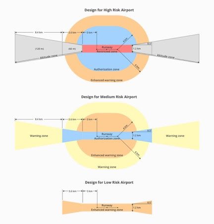
DJI’s new geofencing also incorporates the elements of the recently-enacted U.S. Federal Aviation Administration (FAA) Reauthorization Act. For example, the final approach corridor for active runways at major airports are set to be “runway exclusion zones” for unauthorized drones.

DJI customers should update their DJI GO 4 flight control app and aircraft firmware to ensure these improvements are implemented.

“AOPA applauds DJI’s leadership in geofencing technology, and we appreciate their collaboration with our teams, to create safe and effective systems that allow all to safely enjoy the freedom to fly,” said AOPA President and CEO Mark Baker. “These latest improvements promote safe UAS integration in our aviation community by tailoring the geofence areas around each airport in a manner that has clear advantages for manned and unmanned operators.”

“AAAE appreciates DJI’s efforts to implement these important geofencing improvements,” said Justin Barkowski, AAAE Staff Vice President, Regulatory Affairs. “This is a common-sense approach to enhancing safety in the airport operating environment while providing users with additional areas to safely operate their drones.”

Evolving the GEO system

DJI’s GEO system has received criticism in the past. First, for having the temerity to police flights of its drones in sensitive locations (something most in the industry actively supports). And second, because commercial pilots have – anecdotally, at least – not been provided with permission to fly in a timely enough manner.

GEO prevents DJI drones from taking off in certain locations without special authorization. Although drone pilots with verified DJI accounts can unlock certain no-fly zones providing they have legitimate reasons and the necessary approvals. DJI have said that the approval process has been streamlined to ensure that professional drone pilots with authorization receive unlocking codes within 30 minutes.

The GEO system previously geofenced a 5-mile circle around airports, with enhanced restrictions in a smaller circle encompassing the airport area. The new rectangle system should open more areas on the sides of runways to beneficial drone uses and more low-altitude areas more than 3 kilometers (1.9 miles) from the end of a runway, while increasing protection in the locations where manned aircraft actually fly.

Tensions between AirMap and DJI reach tipping point

Arguably the major talking point from the new GEO update is that DJI has chosen a new data provider, PrecisionHawk. That means that AirMap will no longer be providing geospatial data for DJI’s maps.

“DJI is pleased to partner with companies that support our vision of safe skies that are open to innovation,” Schulman said. “DJI pioneered geofencing for drones, as well as automatic altitude limitations, collision avoidance sensors and a mandatory knowledge quiz about safe flight rules. PrecisionHawk shares DJI’s commitment to ensuring that safety technology enhances the ability of recreational and professional drone pilots to fly.”

But there’s a little more to this than PrecisionHawk’s data capabilities.

AirMap and company co-founder Greg McNeal have long advocated handing over the right to regulate airspace to state and local governments, first through the Drone Federalism Act, which would allow cities, towns and counties to carve up airspace, charge pilots for flying, and generally make it more difficult for recreational and commercial pilots to take to the skies within the law.

For AirMap the opportunity is clear: the more complexity in the airspace, the more money the company stands to make through simplifying that complexity.

Unsurprisingly, the position that skies above the U.S. should become trickier to navigate for drone professionals and enthusiasts is not one that DJI would share.

Malek Murison
Malek Murison

Malek Murison is a freelance writer and editor with a passion for tech trends and innovation. He handles product reviews, major releases and keeps an eye on the enthusiast market for DroneLife.
Email Malek
Twitter:@malekmurison

Subscribe to DroneLife here.

Filed Under: Drone News Feeds, Featured, News Tagged With: AirMap, DJI, GEO, geospatial data, PrecisionHawk

Reader Interactions

Trackbacks

  1. DJI Rolls Out GEO 2.0 Across Europe With New Partner Altitud… – UAV – DRONEENEWS.COM says:
    February 12, 2019 at 1:00 pm

    […] Toward the end of 2018, DJI announced similar changes to its Geofencing across the United States, as well as ditching previous data supplier AirMap for PrecisionHawk. […]

    Reply
  2. 5 Technologies Improving Drone Safety - Droneoo says:
    January 24, 2019 at 4:13 am

    […] Read more: DJI Refines Geofencing and Ditches AirMap for PrecisionHawk […]

    Reply
  3. 5 Technologies Improving Drone Safety | Drone Shop says:
    January 24, 2019 at 1:41 am

    […] Read more: DJI Refines Geofencing and Ditches AirMap for PrecisionHawk […]

    Reply
  4. DJI Refines Geofencing and Ditches AirMap for PrecisionHawk | News and Reviews about Drones, Quadcopter, Camera says:
    October 27, 2018 at 11:30 pm

    […] Source link […]

    Reply
  5. DJI Refines Geofencing and Ditches AirMap for PrecisionHawk - Drones Crunch says:
    October 24, 2018 at 5:26 pm

    […] DRONELIFE […]

    Reply

Leave a Reply Cancel reply

Your email address will not be published. Required fields are marked *

Primary Sidebar

LATEST

Six Takeaways from CIS White Paper on Drone Risks at Public Gatherings

As planning ramps up for the FIFA World Cup 2026, security agencies are preparing for one of the most complex…

Continue Reading Six Takeaways from CIS White Paper on Drone Risks at Public Gatherings

Matternet and SoftBank Robotics America Partner to Scale Drone Delivery Networks

Collaboration targets healthcare and enterprise logistics with focus on real-world deployment Matternet and SoftBank Robotics America have announced a strategic…

Continue Reading Matternet and SoftBank Robotics America Partner to Scale Drone Delivery Networks

FAA Reverses Course on Drone Flight Limits Near Federal Operations

FAA backs down on threat to prosecute drone pilots By DRONELIFE Features Editor Jim Magill The FAA has apparently backed…

Continue Reading FAA Reverses Course on Drone Flight Limits Near Federal Operations

Donecle Raises €10 Million to Expand Drone-Based Aircraft Inspection Platform

Funding will support international growth and further development of AI-driven maintenance solutions Donecle, a France-based company specializing in automated aircraft…

Continue Reading Donecle Raises €10 Million to Expand Drone-Based Aircraft Inspection Platform

Is the U.S. Ready for Drone Threats at World Cup Scale?

U.S. faces multiple challenges in counter-UAS buildup By DRONELIFE Features Editor Jim Magill (Editor’s note: This is part of a…

Continue Reading Is the U.S. Ready for Drone Threats at World Cup Scale?

FAA Moves to Close Drone Enforcement Gap with New DETER Program

As detection outpaces enforcement, the FAA introduces faster penalties for rule-breaking operators Detection Has Outpaced Enforcement Drone detection is no…

Continue Reading FAA Moves to Close Drone Enforcement Gap with New DETER Program

HYFIX Raises $15M to Build U.S.-Made Drone Chip Platform

New system-on-chip aims to replace fragmented electronics with a single secure architecture HYFIX Spatial Intelligence, Inc. has announced a $15…

Continue Reading HYFIX Raises $15M to Build U.S.-Made Drone Chip Platform

FCC Grants Conditional Approval to Sees.ai UAS, Signaling New Path for Foreign Drone Systems

Limited public details raise questions about “v.USA 1.0” and how international companies can meet U.S. security requirements The Federal Communications…

Continue Reading FCC Grants Conditional Approval to Sees.ai UAS, Signaling New Path for Foreign Drone Systems

UK Drone Package for Ukraine Signals Push to Scale Domestic Industry

Largest-ever MOD initiative supports Kyiv while strengthening UK drone manufacturing base As the global race to build sovereign drone capability…

Continue Reading UK Drone Package for Ukraine Signals Push to Scale Domestic Industry

What Are People Really Saying About the Commercial Drone Industry?

Industry survey will shape discussion on real-world challenges and opportunities in commercial drone operations Commercial UAV Expo has announced its…

Continue Reading What Are People Really Saying About the Commercial Drone Industry?

Secondary Sidebar

Footer

SPONSORED

Inspired Flight Gremsy IF800 VIO F1 drones geo week

What Will It Take to Strengthen U.S. Drone Manufacturing? A Conversation with Inspired Flight’s CEO

Global Mapper Mobile data collection

Collection Ground Control Points with Global Mapper Mobile

Military Drone Mapping Solutions

How SimActive’s Correlator3D™ is Revolutionizing Military Mapping: An Exclusive Interview with CEO Philippe Simard

Photogrammetry Accuracy Standards

SimActive Photogrammetry Software: Enabling Users to Meet Accuracy Standards for Over 20 Years

NACT Engineering Parrot ANAFI tether indoor shot

Smart Tether for Parrot ANAFI USA from NACT Engineering

Blue Marble, features global mapper, features Blue Marble

Check Out These New Features in Global Mapper v25 from Blue Marble

About Us | Contact Us | Advertise With Us | Write for Us | Privacy Policy | Terms of Service

The Trusted Source for the Business of Drones.

This website uses cookies and third party services. By clicking OK, you are agreeing to our privacy policy. ACCEPT

Manage consent

Privacy Overview

This website uses cookies to improve your experience while you navigate through the website. Out of these, the cookies that are categorized as necessary are stored on your browser as they are essential for the working of basic functionalities of the website. We also use third-party cookies that help us analyze and understand how you use this website. These cookies will be stored in your browser only with your consent. You also have the option to opt-out of these cookies. But opting out of some of these cookies may affect your browsing experience.
Necessary
Always Enabled
Necessary cookies are absolutely essential for the website to function properly. These cookies ensure basic functionalities and security features of the website, anonymously.
CookieDurationDescription
cookielawinfo-checkbox-analytics11 monthsThis cookie is set by GDPR Cookie Consent plugin. The cookie is used to store the user consent for the cookies in the category "Analytics".
cookielawinfo-checkbox-functional11 monthsThe cookie is set by GDPR cookie consent to record the user consent for the cookies in the category "Functional".
cookielawinfo-checkbox-necessary11 monthsThis cookie is set by GDPR Cookie Consent plugin. The cookies is used to store the user consent for the cookies in the category "Necessary".
cookielawinfo-checkbox-others11 monthsThis cookie is set by GDPR Cookie Consent plugin. The cookie is used to store the user consent for the cookies in the category "Other.
cookielawinfo-checkbox-performance11 monthsThis cookie is set by GDPR Cookie Consent plugin. The cookie is used to store the user consent for the cookies in the category "Performance".
viewed_cookie_policy11 monthsThe cookie is set by the GDPR Cookie Consent plugin and is used to store whether or not user has consented to the use of cookies. It does not store any personal data.
Functional
Functional cookies help to perform certain functionalities like sharing the content of the website on social media platforms, collect feedbacks, and other third-party features.
Performance
Performance cookies are used to understand and analyze the key performance indexes of the website which helps in delivering a better user experience for the visitors.
Analytics
Analytical cookies are used to understand how visitors interact with the website. These cookies help provide information on metrics the number of visitors, bounce rate, traffic source, etc.
Advertisement
Advertisement cookies are used to provide visitors with relevant ads and marketing campaigns. These cookies track visitors across websites and collect information to provide customized ads.
Others
Other uncategorized cookies are those that are being analyzed and have not been classified into a category as yet.
SAVE & ACCEPT